|
| Mesoscale Discussion 1280 |
|
< Previous MD Next MD >
|
|
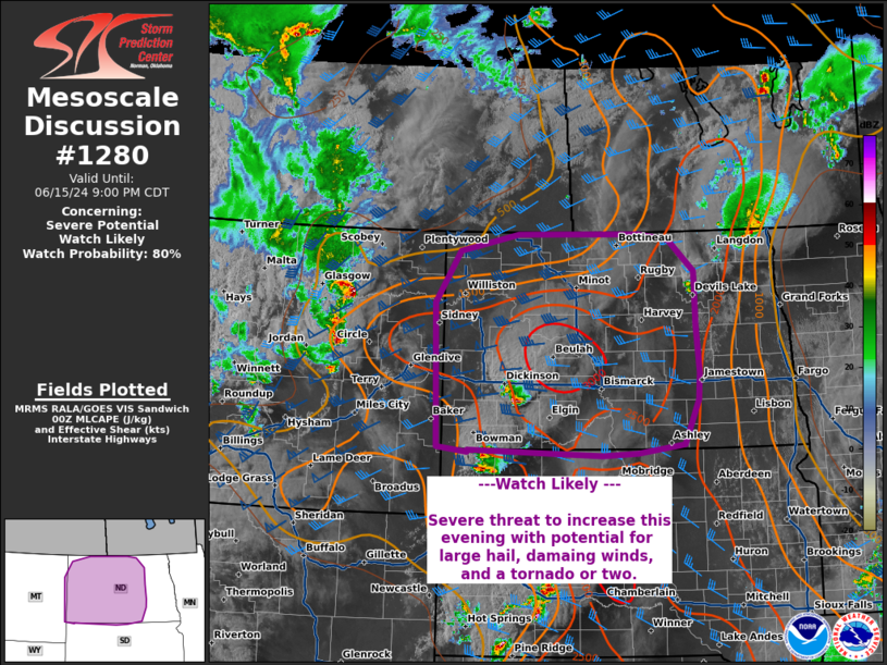
   Mesoscale Discussion 1280
   NWS Storm Prediction Center Norman OK
   0755 PM CDT Sat Jun 15 2024

   Areas affected...western/central North Dakota

   Concerning...Severe potential...Watch likely

   Valid 160055Z - 160200Z

   Probability of Watch Issuance...80 percent

   SUMMARY...Risk of severe storms with potential for large hail,
   damaging wind, and a tornado or two increasing into the evening.

   DISCUSSION...Supercells have developed across northern South Dakota
   and in western North Dakota this afternoon. Thunderstorm activity
   will increase this evening as a line of thunderstorms moves eastward
   out of Montana and additional thunderstorms develop along an
   eastward progressing cold front. These storms will be moving into an
   environment with favorable shear (40-50 kts 0-6 km) and instability
   (MLCAPE 2000-2500 J/kg) to support potential for a few discrete
   supercells and bowing linear segments capable of damaging winds,
   large hail, and a tornado or two. A watch will be needed soon to
   cover this threat.

   ..Thornton/Smith.. 06/16/2024

   ...Please see www.spc.noaa.gov for graphic product...

   ATTN...WFO...FGF...ABR...BIS...UNR...BYZ...GGW...

   LAT...LON   45920352 45890351 45970414 47990423 48720371 48960250
               48979997 48899936 48449882 47689880 47009874 46629878
               46009907 45870004 45840075 45920352
|
|
Top/All Mesoscale Discussions/Forecast Products/Home
|
|


 @NWSSPC