|
| Mesoscale Discussion 1246 |
|
< Previous MD Next MD >
|
|
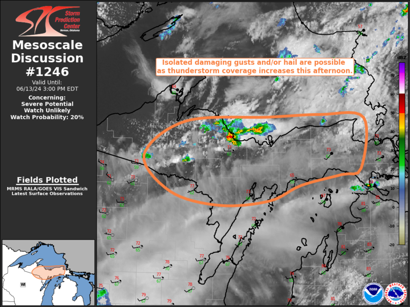
   Mesoscale Discussion 1246
   NWS Storm Prediction Center Norman OK
   1155 AM CDT Thu Jun 13 2024

   Areas affected...Upper MI

   Concerning...Severe potential...Watch unlikely

   Valid 131655Z - 131900Z

   Probability of Watch Issuance...20 percent

   SUMMARY...Isolated damaging gusts and/or hail are possible across
   Upper Michigan as thunderstorm coverage increasing this afternoon.

   DISCUSSION...Recent visible satellite imagery has shown a gradually
   increasing depth to the cumulus along and just ahead of the cold
   front pushing southeastward across the region. Regional radar
   imagery and lightning data reveal that convective initiation has
   occurred across Marquette County MI as well as the cell that is just
   offshore north of the Marquette/Alger county line. Thunderstorm
   coverage is expected to increase over the next hour or so as the
   airmass continues to destabilize and the front pushes southeastward.
   Buoyancy is expected to remain fairly modest with MLCAPE likely
   remaining below 1500 J/kg. Deep-layer vertical shear is already
   strong, with the MQT VAD sampling over 60 kt of 0-6 km bulk shear,
   with some additional strengthening possible as mid-level flow
   increases. General expectation is for a fast-moving multicellular
   mode, with a few isolated storms briefly becoming strong enough to
   produce damaging wind gusts and perhaps even an instance or two of
   hail. Severe coverage is expected to be limited, likely precluding
   the need for watch, but convective trends will be monitored closely.

   ..Mosier/Gleason.. 06/13/2024

   ...Please see www.spc.noaa.gov for graphic product...

   ATTN...WFO...APX...MQT...GRB...

   LAT...LON   46108488 46018527 45878606 45668668 45608765 45788859
               46278912 46748832 46808669 46838566 46798482 46108488
|
|
Top/All Mesoscale Discussions/Forecast Products/Home
|
|


 @NWSSPC