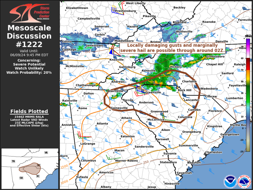
   Mesoscale Discussion 1222
   NWS Storm Prediction Center Norman OK
   0649 PM CDT Sun Jun 09 2024

   Areas affected...Portions of southwestern NC...northwestern SC...and
   far northeast GA

   Concerning...Severe potential...Watch unlikely

   Valid 092349Z - 100145Z

   Probability of Watch Issuance...20 percent

   SUMMARY...Locally damaging gusts and marginally severe hail are
   possible through around 02Z. A watch is not currently expected.

   DISCUSSION...A cluster of storms is evolving along the leading edge
   of antecedent outflow over western NC as of 2340Z, though
   organization has been limited thus far. As these storms continue
   east-southeastward through around 02Z, there is some potential for
   the development of a loosely organized cluster (and perhaps
   transient supercell structures), given a warm/moist pre-convective
   boundary layer and around 40-50 kt of unidirectional effective
   shear. However, poor midlevel lapse rates (contributing to a
   weak/skinny buoyancy profile), limited large-scale ascent, and
   time-of-day may tend to limit overall intensity/organization of
   storms. Nevertheless, locally damaging gusts (45-60 mph) and
   marginally severe hail (to near 1 inch) cannot be ruled out.
   Additional strong/loosely organized cellular development is also
   possible trailing southwestward into far northeastern GA, with a
   localized risk for strong gusts and marginally severe hail.
   Currently, the severe threat appears too localized and marginal for
   a watch, though convective trends will be monitored.

   ..Weinman/Bunting.. 06/09/2024

   ...Please see www.spc.noaa.gov for graphic product...

   ATTN...WFO...RAH...ILM...CAE...GSP...MRX...FFC...

   LAT...LON   35338029 35578066 35688112 35678147 35458196 35278254
               35068346 34968389 34748406 34508405 34318369 34288337
               34338284 34218241 33928163 33878089 34258034 34638013
               34988006 35338029
|


 @NWSSPC