|
| Mesoscale Discussion 407 |
|
< Previous MD Next MD >
|
|
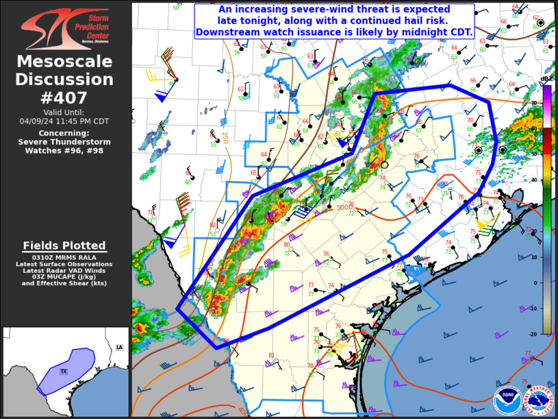
   Mesoscale Discussion 0407
   NWS Storm Prediction Center Norman OK
   1012 PM CDT Tue Apr 09 2024

   Areas affected...Parts of south and southeast TX

   Concerning...Severe Thunderstorm Watch 96...98...

   Valid 100312Z - 100445Z

   The severe weather threat for Severe Thunderstorm Watch 96, 98
   continues.

   SUMMARY...An increasing severe-wind threat is expected late tonight,
   along with a continued hail risk. Downstream watch issuance is
   likely by midnight CDT.

   DISCUSSION...A supercell cluster near/east of Austin has shown signs
   of accelerating eastward late this evening, with a substantial hail
   core recently noted in MRMS data near Bastrop. MLCAPE of greater
   than 2000 J/kg and favorable deep-layer shear will continue to
   support large hail (potentially greater than 2 inches in diameter)
   with embedded supercells in the cluster. Consolidating outflows may
   also pose an increasing severe-wind threat as this cluster moves
   eastward late tonight.

   Farther southwest, deep convection has recently erupted across
   southern portions of the Hill Country into western parts of deep
   south TX, where a cold front has intercepted returning low-level
   moisture. Instability and deep-layer shear are favorable for
   supercells in this region as well, and a threat for large to very
   large hail will accompany these storms as they move eastward. Most
   recent CAM guidance suggests eventual upscale growth in this region,
   which will then move quickly east-northeastward toward the TX Gulf
   Coast with time, accompanied by a threat for severe wind gusts
   potentially exceeding 75 mph. Some tornado threat could also
   eventually evolve near the TX Coast overnight, as the upscale
   growing storm cluster encounters deeper moisture and stronger
   low-level flow/shear.

   With a substantial severe threat expected to eventually spread
   toward the TX Gulf Coast, downstream watch issuance is likely by
   midnight CDT.

   ..Dean/Hart.. 04/10/2024

   ...Please see www.spc.noaa.gov for graphic product...

   ATTN...WFO...HGX...FWD...CRP...EWX...

   LAT...LON   28050036 29709916 30349751 31209714 31319586 31049522
               30479511 30159517 29749541 28869659 27819887 27519970
               28050036
|
|
Top/All Mesoscale Discussions/Forecast Products/Home
|
|


 @NWSSPC