|
| Mesoscale Discussion 156 |
|
< Previous MD Next MD >
|
|
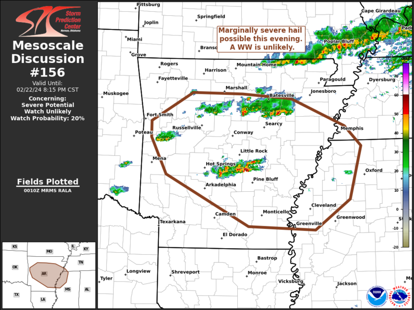
   Mesoscale Discussion 0156
   NWS Storm Prediction Center Norman OK
   0612 PM CST Thu Feb 22 2024

   Areas affected...portions of central Arkansas into northwest
   Mississippi and far southwest Tennessee

   Concerning...Severe potential...Watch unlikely

   Valid 230012Z - 230215Z

   Probability of Watch Issuance...20 percent

   SUMMARY...Isolated strong to severe storms may pose a risk for
   marginally severe hail and gusty winds this evening. A watch is not
   expected.

   DISCUSSION...As of 00z, regional radar analysis showed isolated
   thunderstorms over parts of central and northern AR. Over the past
   30-45 min, a few of these storms have shown occasional weak
   supercell characteristics and deeper reflectively cores. The
   environment is still relatively limited with only 500-1000 J/kg of
   MUCAPE and 25-30 kt of effective shear. While not overly robust, the
   environment should remain capable of supporting marginal storm
   organization for a few hours this evening as storms move
   southeastward. Mid-level lapse rates around 7 c/km and 25-30 kt of
   effective shear may allow for marginally severe hail and or strong
   outflow winds from the strongest storms. The severe threat should
   gradually wane through the later evening hours as the loss of
   diurnal heating and nocturnal stabilization work to weaken ongoing
   storms. Given the limited potential for storm organization, and the
   isolated nature of the severe threat, a weather watch is unlikely.

   ..Lyons/Thompson.. 02/23/2024

   ...Please see www.spc.noaa.gov for graphic product...

   ATTN...WFO...MEG...JAN...LZK...TSA...

   LAT...LON   35049424 35359424 35889333 35869222 35779123 35759110
               35258993 34898958 33918983 33359061 33419208 34379390
               35049424
|
|
Top/All Mesoscale Discussions/Forecast Products/Home
|
|


 @NWSSPC