|
| Mesoscale Discussion 141 |
|
< Previous MD Next MD >
|
|
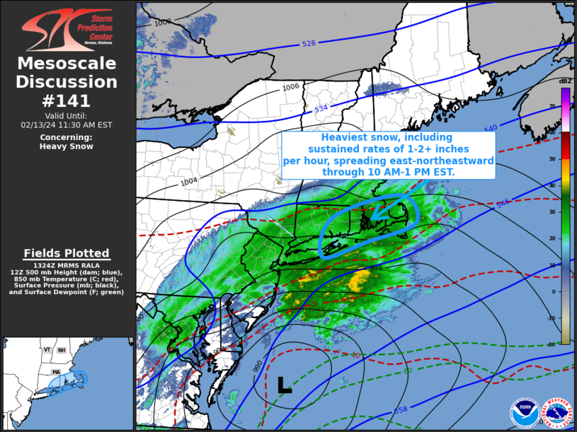
   Mesoscale Discussion 0141
   NWS Storm Prediction Center Norman OK
   0727 AM CST Tue Feb 13 2024

   Areas affected...eastern Long Island through southeastern New
   England

   Concerning...Heavy snow

   Valid 131327Z - 131630Z

   SUMMARY...Heavy snow, including hourly rates increasing in excess of
   2 inches,  appears likely to continue developing east-northeastward
   across eastern Long Island through the Cape Cod vicinity through 10
   AM-1 PM EST.

   DISCUSSION...The rapidly deepening surface cyclone has shifted
   offshore of the Mid Atlantic coast and is likely to continue
   tracking east-northeastward to the south of the Long Island and Cape
   Cod vicinities through midday.  Cooling cloud tops evident in recent
   satellite imagery across southeastern Pennsylvania into the lower
   Hudson Valley appear reflective of a strengthening zone of
   mid/upper-level frontogenesis, which is forecast to continue to
   develop east-northeastward to the north of the surface cyclone.  As
   forcing for ascent within this zone becomes maximized within the
   layer most conducive to large dendritic ice crystal growth
   (temperatures around -15C), initially near or just below 500 mb in
   forecast soundings before slowly lowering, it appears that heaviest
   snow rates will shift across the eastern Long Island/Long Island
   Sound through Cape Cod vicinities between 15-18Z.   With
   precipitable water beginning to approach .8 inches, and lift
   forecast to intensify further, particularly near Cape Cod, heaviest
   sustained snow rates may increase in excess of 2 inches per hour.

   ..Kerr.. 02/13/2024

   ...Please see www.spc.noaa.gov for graphic product...

   ATTN...WFO...BOX...OKX...

   LAT...LON   41727233 42277016 41606965 41167121 40787264 41727233
|
|
Top/All Mesoscale Discussions/Forecast Products/Home
|
|


 @NWSSPC