|
| Mesoscale Discussion 120 |
|
< Previous MD Next MD >
|
|
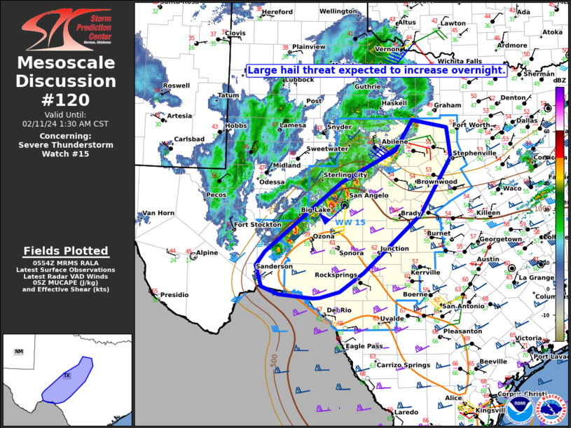
   Mesoscale Discussion 0120
   NWS Storm Prediction Center Norman OK
   1156 PM CST Sat Feb 10 2024

   Areas affected...TX Big Country into the Edwards Plateau

   Concerning...Severe Thunderstorm Watch 15...

   Valid 110556Z - 110730Z

   The severe weather threat for Severe Thunderstorm Watch 15
   continues.

   SUMMARY...The large hail threat is expected to increase overnight as
   storms move eastward.

   DISCUSSION...Elevated convection erupted earlier this evening from
   the western part of the Edwards Plateau into the TX Big Country, as
   an upper low approaching from NM began to impinge on the western
   portion of the primary instability axis. Increasing deep-layer shear
   will be supportive of organized convection overnight as convection
   moves eastward, and a few supercells may continue to evolve (like
   recent development south of Abilene and west of San Angelo) out of
   the ongoing elevated storm cluster overnight. MUCAPE increasing into
   1000 J/kg and steep midlevel lapse rates will continue to support a
   hail threat, with very large hail of 2-2.5 inches in diameter
   possible with any stronger supercell.

   As long as storms remain semi-discrete and elevated, hail will be
   the primary threat, with perhaps some localized strong gusts. If
   convection can build into the southern portion of WW 15 closer to
   the surface boundary, then the threat may increase for a
   near-surface-based supercell, which would pose a conditional risk of
   all severe hazards. That scenario remains very uncertain at this
   time, however.

   ..Dean.. 02/11/2024

   ...Please see www.spc.noaa.gov for graphic product...

   ATTN...WFO...FWD...EWX...SJT...MAF...

   LAT...LON   30510217 31780056 32369941 32939903 32789829 32239821
               31209886 30120009 29780059 29660102 29660115 29730188
               29860225 30260237 30510217
|
|
Top/All Mesoscale Discussions/Forecast Products/Home
|
|


 @NWSSPC