|
| Mesoscale Discussion 84 |
|
< Previous MD Next MD >
|
|
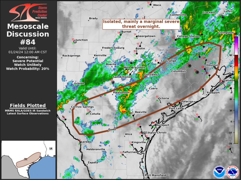
   Mesoscale Discussion 0084
   NWS Storm Prediction Center Norman OK
   1004 PM CST Tue Jan 23 2024

   Areas affected...Parts of South TX

   Concerning...Severe potential...Watch unlikely

   Valid 240404Z - 240600Z

   Probability of Watch Issuance...20 percent

   SUMMARY...Isolated, marginally severe thunderstorms will be possible
   overnight, primarily in the form of hail from 0.75-1.25 inches and
   wind from 40-60 mph.

   DISCUSSION...An uptick in thunderstorm coverage has occurred along
   and to the north of a wavy surface front from Deep South TX into
   southeast TX. The bulk of stronger mid-level flow has been confined
   to the cool side of the front per DFX and EWX VWP data, with
   pronounced weakness in the 1-3 km AGL hodograph in the CRP VWP. As
   such, along the northern gradient of modest MLCAPE amid moderate
   mid-level lapse rates, this setup will probably foster occasional
   mid-level updraft rotation. Marginally severe hail and locally
   strong gusts will likely be the main threats. A longer-duration
   supercell could evolve near the front along the northern fringe of
   mid to upper 60s surface dew points, being supported by relatively
   stronger low-level shear over southeast TX per the HGX VWP. Should
   this conditionally occur, a brief tornado will be possible.

   ..Grams/Thompson.. 01/24/2024

   ...Please see www.spc.noaa.gov for graphic product...

   ATTN...WFO...HGX...CRP...EWX...

   LAT...LON   29389755 30049655 30329597 30449556 30499521 30379483
               29919488 29599500 29079562 28679650 28209773 27939844
               27799914 27789953 28049974 28489979 28689964 29389755
|
|
Top/All Mesoscale Discussions/Forecast Products/Home
|
|


 @NWSSPC