|
| Mesoscale Discussion 1563 |
|
< Previous MD
|
|
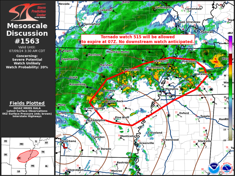
   Mesoscale Discussion 1563
   NWS Storm Prediction Center Norman OK
   0159 AM CDT Tue Jul 09 2024

   Areas affected...northeast Arkansas

   Concerning...Severe potential...Watch unlikely

   Valid 090659Z - 090830Z

   Probability of Watch Issuance...20 percent

   SUMMARY...Low tornado threat may persist through the early morning
   hours. No additional tornado watch is anticipated early this
   morning.

   DISCUSSION...Tornado watch 515 will be allowed to expire at 07Z.
   Occasional low-level circulation has been evident from the KLZK and
   KNQA WSR-88Ds, but storm activity is becoming increasingly
   concentrated within weaker buoyancy and heavy rain where more robust
   updrafts are less likely. Given the favorable low-level shear
   apparent on the KNQA VWP, intermittent stronger low-level rotation
   remains possible, but expect the primary tornado threat to have
   diminished.

   A downstream/replacement tornado watch is not expected.

   ..Bentley/Smith.. 07/09/2024

   ...Please see www.spc.noaa.gov for graphic product...

   ATTN...WFO...MEG...LZK...

   LAT...LON   34759297 35509233 36039086 36218983 36148887 35878846
               35598837 35198882 34838970 34419054 34039130 34119204
               34229245 34759297
|
|
Top/All Mesoscale Discussions/Forecast Products/Home
|
|


 @NWSSPC