|
| Mesoscale Discussion 1513 |
|
< Previous MD Next MD >
|
|
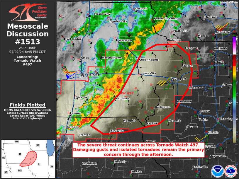
   Mesoscale Discussion 1513
   NWS Storm Prediction Center Norman OK
   0513 PM CDT Tue Jul 02 2024

   Areas affected...portions of eastern Iowa into extreme northeastern
   Missouri...extreme western Illinois

   Concerning...Tornado Watch 497...

   Valid 022213Z - 022345Z

   The severe weather threat for Tornado Watch 497 continues.

   SUMMARY...The severe threat continues across Tornado Watch 497.
   Severe gusts and QLCS tornadoes are possible with an MCS over the
   next few hours.

   DISCUSSION...A mature QLCS is moving eastward across eastern Iowa
   into far northern MO amid strong deep-layer shear and buoyancy (i.e.
   50-60 kts of effective bulk shear and 2000-3000 J/kg MLCAPE). On the
   MCS leading line, multiple mesovortices have developed, showing up
   to 40 kt rotational velocities, suggesting that low-level
   circulations are strong enough to support damaging gusts and
   potential tornadogenesis. The DVN VAD profiler shows an appreciably
   large and curved hodograph, with over 300 m2/s2 0-3 km SRH, which
   would certainly support additional tornado potential when also
   considering ample available buoyancy. At the moment, southeastern
   Iowa, which is the near the apex of the bowing QLCS, has the best
   short-term tornado potential.

   ..Squitieri.. 07/02/2024

   ...Please see www.spc.noaa.gov for graphic product...

   ATTN...WFO...ILX...LSX...DVN...DMX...EAX...

   LAT...LON   40369321 41219225 41649193 42259151 42449102 42439032
               42178992 41758982 41338994 40749043 40439095 40239200
               40169278 40369321
|
|
Top/All Mesoscale Discussions/Forecast Products/Home
|
|


 @NWSSPC