|
| Mesoscale Discussion 1483 |
|
< Previous MD Next MD >
|
|
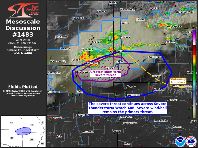
   Mesoscale Discussion 1483
   NWS Storm Prediction Center Norman OK
   0636 PM CDT Sat Jun 29 2024

   Areas affected...portions of extreme southeast Kansas into far
   northeast Oklahoma...southwestern Missouri...and extreme
   northwestern Arkansas

   Concerning...Severe Thunderstorm Watch 486...

   Valid 292336Z - 300100Z

   The severe weather threat for Severe Thunderstorm Watch 486
   continues.

   SUMMARY...The severe threat continues across Severe Thunderstorm
   Watch 486. Severe wind and hail remain the primary threats. The best
   chance for severe wind/hail in the near-term exists with a cluster
   of storms along the KS/OK border

   DISCUSSION...Several thunderstorm clusters have developed along the
   cold front, with a mature, dominant cluster progressing across
   southeast KS toward OK. This cluster has a history of large hail and
   severe gusts, and these storms continue to track southward into a
   strongly unstable airmass. As such, additional instances of severe
   wind and hail should continue with this cluster over the next
   several hours. These storms may progress just south of the WW 486
   bounds, potentially necessitating the need of an additional
   downstream Severe Thunderstorm Watch issuance. There is also a
   slight chance for storms to initiate along a stationary boundary
   across extreme northern Arkansas. Should this occur, multicells may
   result, posing a threat of severe wind and hail.

   ..Squitieri.. 06/29/2024

   ...Please see www.spc.noaa.gov for graphic product...

   ATTN...WFO...LZK...SGF...TSA...ICT...

   LAT...LON   36129340 35979454 36139561 36539611 36829615 36959601
               37249515 37459431 37409285 36809240 36359264 36129340
|
|
Top/All Mesoscale Discussions/Forecast Products/Home
|
|


 @NWSSPC