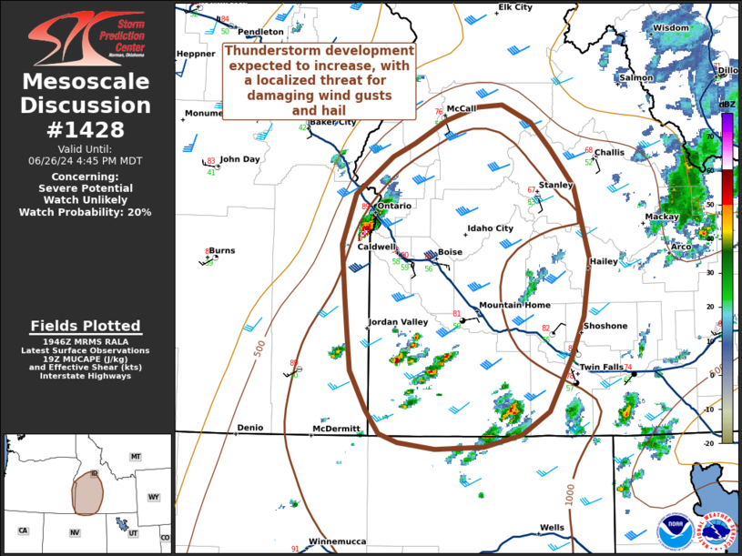
   Mesoscale Discussion 1428
   NWS Storm Prediction Center Norman OK
   0247 PM CDT Wed Jun 26 2024

   Areas affected...Southwestern Idaho

   Concerning...Severe potential...Watch unlikely

   Valid 261947Z - 262245Z

   Probability of Watch Issuance...20 percent

   SUMMARY...Scattered thunderstorms have developed over Southwestern
   ID in an environment supportive of isolated damaging wind gusts,
   marginally severe hail. Given overall uncertainty in convective
   coverage and longevity, weather watch issuance is not expected at
   this time.

   DISCUSSION...Scattered thunderstorms are expected to continue to
   develop this afternoon across Southwestern ID, as an upper-level
   shortwave trough over OR and WA continues to advance towards
   southern British Columbia. Surface temperatures have warmed into the
   upper 80s F, with dewpoints in the upper 50s F, resulting in MUCAPE
   of 1000-1500 J/kg beneath 35-45 kts of deep layer vertical shear.
   Additionally, a local maxima of 0-1 km SRH is evident near Boise on
   both SPC Mesoanalysis and the Boise VAD wind profile, with values
   between 100-140 m^2/s^2.

   While the overall coverage and intensity of severe weather is
   expected to remain marginal, storms in this environment will be
   capable of isolated damaging wind gusts, and hail near 1-inch.

   Given uncertainty in convective coverage and intensity, weather
   watch issuance is not expected at this time, though convective
   trends will continue to be monitored.

   ..Halbert/Weinman/Hart.. 06/26/2024

   ...Please see www.spc.noaa.gov for graphic product...

   ATTN...WFO...PIH...BOI...LKN...

   LAT...LON   43601429 43071437 42711451 42211479 42001514 41901560
               41881620 41941667 42011690 42221706 42591725 42951730
               43261732 43721737 44191720 44521673 44641647 44861606
               44981568 44991537 44841500 44591477 44261448 43601429
|


 @NWSSPC