|
| Mesoscale Discussion 1260 |
|
< Previous MD Next MD >
|
|
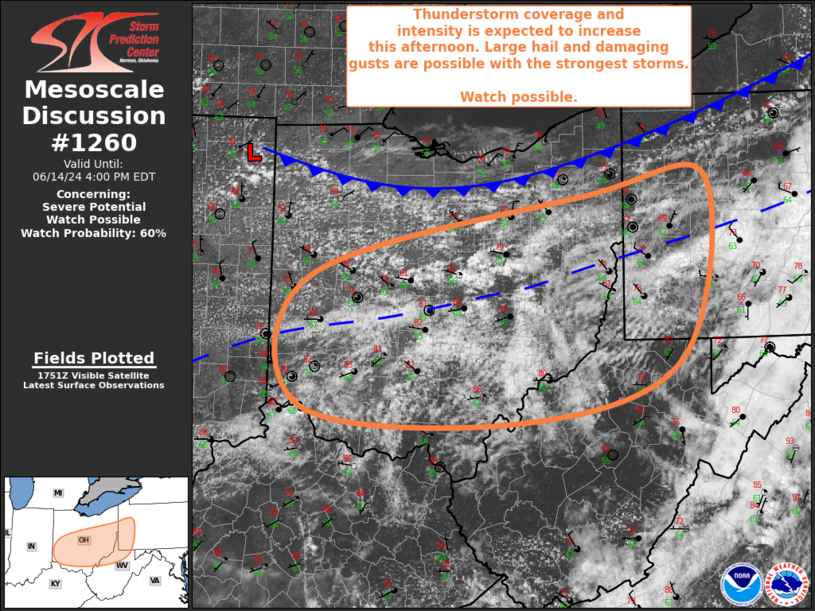
   Mesoscale Discussion 1260
   NWS Storm Prediction Center Norman OK
   1255 PM CDT Fri Jun 14 2024

   Areas affected...Much of OH...Northern WV/Northern WV
   Panhandle...Western PA

   Concerning...Severe potential...Watch possible

   Valid 141755Z - 142000Z

   Probability of Watch Issuance...60 percent

   SUMMARY...Thunderstorm coverage and intensity is expected to
   increase from Ohio into northern West Virginia and western
   Pennsylvania this afternoon. Large hail and damaging gusts are
   possible with the strongest storms and a watch will probably be
   needed over portions of the area.

   DISCUSSION...Visible satellite imagery has shown an expanding and
   deepening cumulus field from OH eastward into western PA beneath the
   mid-level clouds over the past hour or so. The only exception is
   across southern OH into northern WV/northern WV Panhandle, where
   billow clouds suggest these areas still have some low-level
   stability in place. General expectation is that continued heating
   should destabilize the airmass in these areas as well. The primary
   front is still north of the region, but low-level convergence within
   the warm sector, particularly near a weak pre-frontal trough, is
   expected to support thunderstorm development as the airmass
   continues to destabilize. Modest buoyancy is already in place, with
   mesoanalysis estimating MLCAPE currently around 1000 J/kg. Some
   additional heating is possible, likely bring MLCAPE closer to 1500
   J/kg later this afternoon. Strengthening mid-level flow is
   anticipated as well, helping to increase effective bulk shear to
   around 45 to 50 kt.

   These environmental conditions will likely support strong to severe
   storms capable of both large hail and damaging gusts. Overall severe
   coverage is still uncertain, but the trends within the visible
   imagery suggest that coverage will likely be sufficient to merit a
   watch.

   ..Mosier/Gleason.. 06/14/2024

   ...Please see www.spc.noaa.gov for graphic product...

   ATTN...WFO...PBZ...RLX...CLE...ILN...

   LAT...LON   40318431 41078095 41247951 39537981 38948172 39088440
               40318431
|
|
Top/All Mesoscale Discussions/Forecast Products/Home
|
|


 @NWSSPC