|
| Mesoscale Discussion 1221 |
|
< Previous MD Next MD >
|
|
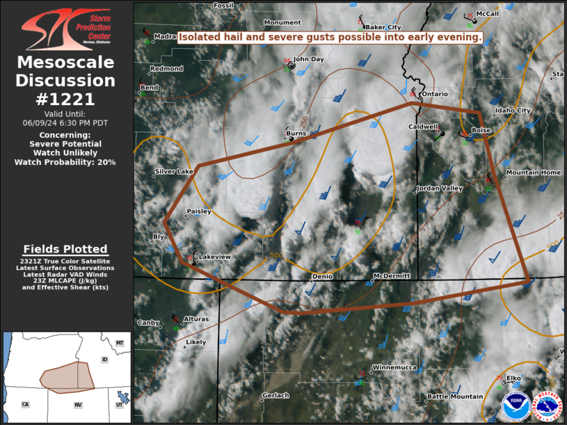
   Mesoscale Discussion 1221
   NWS Storm Prediction Center Norman OK
   0628 PM CDT Sun Jun 09 2024

   Areas affected...Southeast OR into southwest ID and extreme northern
   NV

   Concerning...Severe potential...Watch unlikely

   Valid 092328Z - 100130Z

   Probability of Watch Issuance...20 percent

   SUMMARY...Isolated hail and severe gusts are possible into early
   evening.

   DISCUSSION...Scattered thunderstorms are ongoing across southeast OR
   and vicinity, in advance of a shortwave trough moving across the
   Pacific Northwest. MLCAPE of up to 500 J/kg and moderate deep-layer
   shear are supporting occasionally organized storm structures, with a
   couple of stronger cells noted across Malheur County, Oregon. Those
   cells will eventually encounter stronger MLCINH to the northeast,
   but isolated hail and severe gusts will remain possible in the short
   term. Other less-organized convection is ongoing farther west into
   south-central OR, and also moving out of far northern NV. A stronger
   cell or two could develop across those areas as well, but even the
   ongoing less-organized convection could pose a threat of isolated
   strong to severe gusts, especially where the environment remains
   rather warm and well mixed.

   ..Dean/Bunting.. 06/09/2024

   ...Please see www.spc.noaa.gov for graphic product...

   ATTN...WFO...BOI...LKN...REV...MFR...

   LAT...LON   41641905 41901981 42172057 42612086 43252035 43541891
               43971710 43851605 43151585 41951536 41731709 41631876
               41641905
|
|
Top/All Mesoscale Discussions/Forecast Products/Home
|
|


 @NWSSPC