|
| Mesoscale Discussion 1121 |
|
< Previous MD Next MD >
|
|
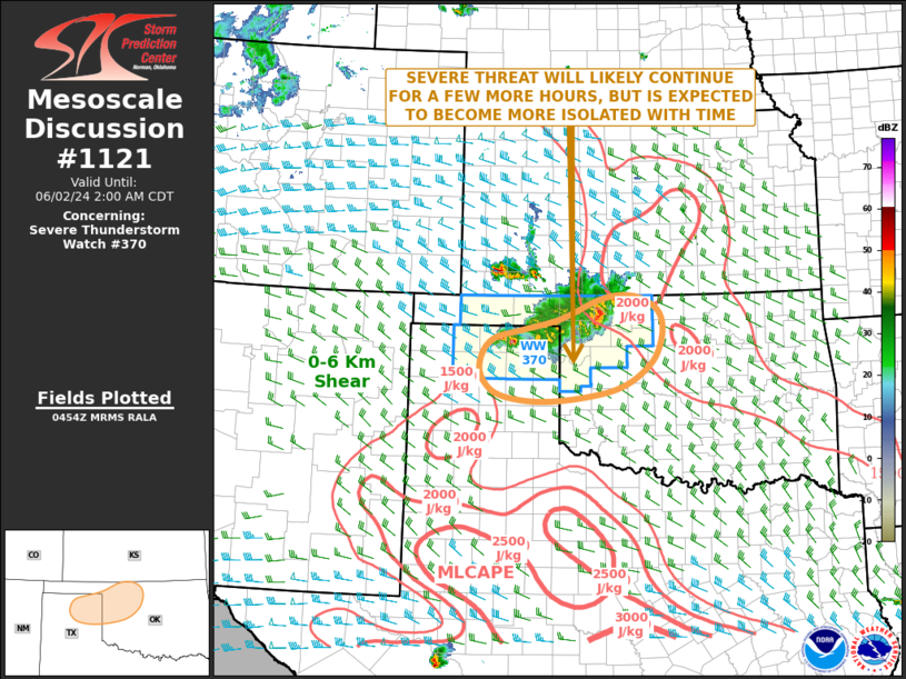
   Mesoscale Discussion 1121
   NWS Storm Prediction Center Norman OK
   1156 PM CDT Sat Jun 01 2024

   Areas affected...Eastern Texas Panhandle...Northwest Oklahoma

   Concerning...Severe Thunderstorm Watch 370...

   Valid 020456Z - 020700Z

   The severe weather threat for Severe Thunderstorm Watch 370
   continues.

   SUMMARY...A severe threat is likely to continue for a few more hours
   from the eastern Texas Panhandle into northwest Oklahoma. Isolated
   large hail and severe wind gusts will be possible. The severe threat
   is expected to gradually become more isolated with time.

   DISCUSSION...The latest hi-resolution radar imagery from Vance Air
   Force Base shows a cluster of strong to severe storms from the
   northeastern Texas Panhandle into northwest Oklahoma. This feature
   is located along the southwestern edge of a corridor of moderate
   instability, where the RAP is analyzing MLCAPE in the 1500 to 2500
   J/kg range. The WSR-88D VWP in northwest Oklahoma currently has
   gradually veering winds in the lowest 2 km with flow generally at 30
   knots. This is also evident on RAP forecast soundings which shows
   0-6 km shear in the 25 to 30 knot range. This still could be enough
   to continue a threat for severe wind gusts with the stronger cells
   within the cluster. However, instability is weaker across much of
   western and central Oklahoma. As this cluster moves southeastward,
   the severe weather potential is expected to become more isolated
   with time.

   ..Broyles.. 06/02/2024

   ...Please see www.spc.noaa.gov for graphic product...

   ATTN...WFO...OUN...DDC...AMA...

   LAT...LON   35340120 35660159 36000159 36290133 36420078 36609999
               36939920 37019869 36929827 36709796 36319792 35849817
               35449887 35250020 35340120
|
|
Top/All Mesoscale Discussions/Forecast Products/Home
|
|


 @NWSSPC