|
| Mesoscale Discussion 1115 |
|
< Previous MD Next MD >
|
|
Mesoscale Discussion 1115
NWS Storm Prediction Center Norman OK
0456 PM CDT Sat Jun 01 2024
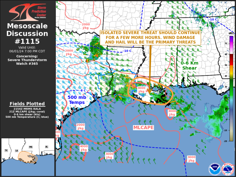
Areas affected...Southeast Louisiana...Far Southern Mississippi
Concerning...Severe Thunderstorm Watch 365...
Valid 012156Z - 020000Z
The severe weather threat for Severe Thunderstorm Watch 365
continues.
SUMMARY...A severe threat will likely continue across parts of
southeast Louisiana and far southern Mississippi over the next few
hours. Wind damage and hail will be the primary threats.
DISCUSSION...The latest hi-resolution radar from Slidell, LA shows
scattered strong to occasionally severe thunderstorms across
southern Louisiana. These storms are located in a moderately
unstable airmass, with the RAP showing MLCAPE generally from 2000 to
3000 J/kg. RAP forecasts late this afternoon for the same general
area have 0-6 km shear in the 20 to 25 knot range, suggesting that
the convection will remain unorganized. In spite of the limited
shear, surface dewpoints are in the 70 to 75 F degree range, and
low-level lapse rates are steep. This should be enough for isolated
damaging wind gusts. Hail will also be possible. The threat is
expected to become more isolated by early evening as the airmass
gradually turns over.
..Broyles/Hart.. 06/01/2024
...Please see www.spc.noaa.gov for graphic product...
ATTN...WFO...LIX...LCH...
LAT...LON 30339220 30799188 30949122 30578994 30118901 29688882
29228923 29118976 29329117 29739220 30339220
|
|
Top/All Mesoscale Discussions/Forecast Products/Home
|
|


 @NWSSPC