|
| Mesoscale Discussion 1086 |
|
< Previous MD Next MD >
|
|
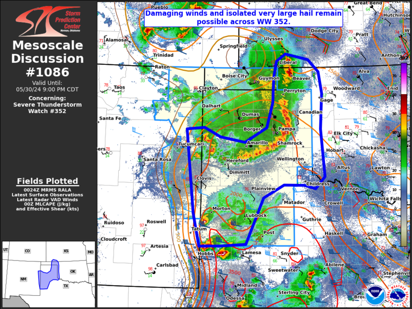
   Mesoscale Discussion 1086
   NWS Storm Prediction Center Norman OK
   0725 PM CDT Thu May 30 2024

   Areas affected...The Texas and Oklahoma Panhandles...and the Texas
   Caprock

   Concerning...Severe Thunderstorm Watch 352...

   Valid 310025Z - 310200Z

   The severe weather threat for Severe Thunderstorm Watch 352
   continues.

   SUMMARY...Severe, damaging wind gusts near 60-70 mph and localized
   very large hail near 2.0-3.5" in diameter will continue across the
   severe thunderstorm watch.

   DISCUSSION...Recent radar data from KAMA and KLBB indicate two main
   areas of severe threat concern. The first is associated with a QLCS
   progressing southeastward across the TX and OK Panhandles, where
   wind gusts around 65 mph have already been reported behind an
   outflow boundary and deepening cold pool. The outflow boundary
   associated with this system is now preceding the convergence zone,
   and as it progresses into the southern TX panhandle and TX/OK
   border, a general weakening trend is anticipated. This unfavorable,
   downstream environment is indicative of larger CINH via the cold
   pool from today's earlier convective complex. Therefore, a
   downstream WW into OUN's CWA is not anticipated at this time. A few
   updrafts may manage to develop along the new outflow boundary near
   the AMA/LUB CWA border.

   Further south, west and southwest of Lubbock, discrete thunderstorms
   and transient supercells continue to develop off the residual
   north-south outflow boundary. Large hail will be favored here, where
   westerly deep layer effective shear of 55-60 kt coincides with a
   narrow corridor of steep mid-level lapse rates.

   ..Barnes.. 05/31/2024

   ...Please see www.spc.noaa.gov for graphic product...

   ATTN...WFO...OUN...DDC...LUB...AMA...MAF...ABQ...

   LAT...LON   32960249 32950307 33700324 35590345 35640297 35430252
               35310184 35630124 36200107 36770105 37150097 37300071
               37180009 36899979 36419971 35609975 34529965 34259991
               34330023 34340077 34050133 33000182 32960249
|
|
Top/All Mesoscale Discussions/Forecast Products/Home
|
|


 @NWSSPC