|
| Mesoscale Discussion 880 |
|
< Previous MD Next MD >
|
|
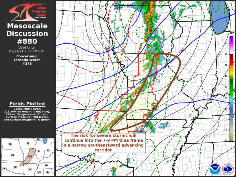
   Mesoscale Discussion 0880
   NWS Storm Prediction Center Norman OK
   0533 PM CDT Tue May 21 2024

   Areas affected...parts of west central Illinois and northeastern
   Missouri southwestward into northeastern Oklahoma

   Concerning...Tornado Watch 278...

   Valid 212233Z - 220030Z

   The severe weather threat for Tornado Watch 278 continues.

   SUMMARY...Supercell development will persist in narrow
   east-southeastward pre-frontal corridor, with some potential the
   continued evolution of an organizing squall line through 7-9 PM CDT.
    Stronger storms will continue to pose a risk for large hail,
   locally damaging wind gusts and a couple of tornadoes.

   DISCUSSION...Thunderstorm development persists just east of the
   dryline as a southeastward advancing cold front overtakes it.
   Activity has evolved into a mix of linear and discrete supercell
   cell structures, which will tend to slowly shift southeastward as
   the deep cyclone continues migrating northeastward through the Upper
   Midwest, and flow to its south veers to a more prominent westerly
   component and begins to weaken.

   Convection is still embedded within strong southwesterly deep-layer
   mean flow in excess of 50 kt, which is supporting fast northeasterly
   cell motion, but at least somewhat drier and less unstable
   boundary-layer air lingers across south central through east central
   Missouri and west central Illinois.  Stronger convective development
   probably will remain focused in the rather narrow corridor of better
   pre-frontal low-level, which guidance does suggest will tend to
   shift eastward ahead of the front toward the middle Mississippi
   Valley through 01-03Z.

   Within this narrow corridor, large CAPE and strong shear will
   maintain a risk for severe hail/wind and potential for a couple of
   tornadoes several more hours

   ..Kerr.. 05/21/2024

   ...Please see www.spc.noaa.gov for graphic product...

   ATTN...WFO...ILX...LSX...DVN...SGF...EAX...TSA...

   LAT...LON   40539230 39949043 36969267 36199384 35839584 37409421
               39489283 40539230
|
|
Top/All Mesoscale Discussions/Forecast Products/Home
|
|


 @NWSSPC