|
| Mesoscale Discussion 822 |
|
< Previous MD Next MD >
|
|
Mesoscale Discussion 0822
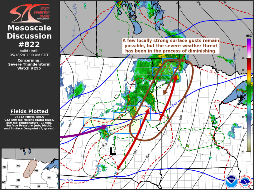
NWS Storm Prediction Center Norman OK
1137 PM CDT Fri May 17 2024
Areas affected...southeastern North Dakota...northeastern South
Dakota...west central/northwestern Minnesota
Concerning...Severe Thunderstorm Watch 255...
Valid 180437Z - 180600Z
The severe weather threat for Severe Thunderstorm Watch 255
continues.
SUMMARY...A few locally strong surface gusts remain possible with
lingering convection spreading across and east of the Red River
vicinity through 1-2 AM CDT, but the severe weather threat appears
to have generally diminished.
DISCUSSION...A convective outflow driven/enhanced cold front has
advanced east of the the Red River, and southeastward through
central South Dakota portions of the mid Missouri Valley. Ahead of
this boundary, lower/mid-levels remain relatively dry as the
boundary-layer continues to cool, resulting in diminishing
instability. However, mid-level lapse rates are still steep enough
to maintain sufficient instability to support continuing convective
development in the presence of strong lift along a 30-50+ kt
southerly 850 mb jet axis. While stronger convection is
increasingly focused to the cool side of the surface front,
thermodynamic profiles may remain conducive to occasional strong,
but generally sub-severe, surface gusts in the more vigorous
lingering convection as it gradually spreads eastward into the
overnight hours.
..Kerr.. 05/18/2024
...Please see www.spc.noaa.gov for graphic product...
ATTN...WFO...DLH...MPX...FGF...ABR...BIS...
LAT...LON 48749430 47809432 46519536 45109688 44979819 45569872
46719792 48529655 48929584 48749430
|
|
Top/All Mesoscale Discussions/Forecast Products/Home
|
|


 @NWSSPC