|
| Mesoscale Discussion 819 |
|
< Previous MD Next MD >
|
|
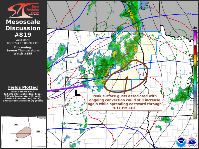
   Mesoscale Discussion 0819
   NWS Storm Prediction Center Norman OK
   0807 PM CDT Fri May 17 2024

   Areas affected...southeastern North Dakota and northeastern South
   Dakota

   Concerning...Severe Thunderstorm Watch 255...

   Valid 180107Z - 180300Z

   The severe weather threat for Severe Thunderstorm Watch 255
   continues.

   SUMMARY...Peak surface gusts associated with ongoing thunderstorms
   have generally subsided, but could still increase once again across
   parts of northeastern South Dakota and southeastern North Dakota
   through 9-11 PM CDT.

   DISCUSSION...Based on cooling cloud tops, radar and lightning data,
   convection has undergone recent intensification in a cluster
   centered across south central North Dakota, and now shifting east of
   the Missouri River.  This appears near the exit region of a
   seasonably strong high-level jet streak nosing into the northern
   high plains, which may help maintain convection as it spreads toward
   the Red River Valley this evening.

   Although probably unaccompanied by appreciable low-level moistening,
   the Rapid Refresh indicates considerable strengthening of
   south-southwesterly flow around 850 mb across central Nebraska
   toward the Watertown SD vicinity through 02-04Z.  Forcing on the
   nose of this low-level jet may augment the upper support for
   convection, in the presence of limited instability, and downward
   mixing of this momentum could also support another uptick in
   potential for severe surface gusts.

   ..Kerr.. 05/18/2024

   ...Please see www.spc.noaa.gov for graphic product...

   ATTN...WFO...FGF...ABR...BIS...

   LAT...LON   45530047 46269974 46649874 47179771 46689651 45799689
               45219839 45149975 45530047
|
|
Top/All Mesoscale Discussions/Forecast Products/Home
|
|


 @NWSSPC