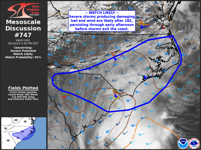
   Mesoscale Discussion 0747
   NWS Storm Prediction Center Norman OK
   1205 PM CDT Fri May 10 2024

   Areas affected...the central and eastern Carolinas

   Concerning...Severe potential...Watch likely

   Valid 101705Z - 101930Z

   Probability of Watch Issuance...95 percent

   SUMMARY...Scattered severe storms are likely to develop after 18Z
   over the central Carolinas, producing damaging hail and wind through
   early evening as they eventually exit the Atlantic Coast.

   DISCUSSION...Surface analysis shows a deepening trough extending
   from southeast VA across central NC and into northern SC, with
   temperatures heating into the upper 70s F. Dewpoints remain in the
   60s F, but may gradually mix down a few degrees by peak heating.

   Morning soundings show steep midlevel lapse rates in place, as well
   as ample deep-layer shear with mid to high level flow of 50 to 100
   kt. This combination is resulting in a favorable environment for
   large hail, and perhaps a few fast-moving bowing structures with
   damaging winds.

   As of 17Z, visible imagery is already showing developing towering CU
   over northern SC and into central NC. The presence of cirrus from
   the MCS to the south may have slowed heating a bit, but clearing
   should continue, aiding destabilization.

   Scattered to numerous storms are expected to form over the next few
   hours along the boundary, with both cells and congealing line
   segments possible. Some of the more isolated hail storms may produce
   large amounts of 1.00 to 1.75" hail, with cold, severe downdrafts
   possible as well.

   ..Jewell/Thompson.. 05/10/2024

   ...Please see www.spc.noaa.gov for graphic product...

   ATTN...WFO...AKQ...MHX...RAH...ILM...CAE...GSP...

   LAT...LON   36477580 36067555 35617536 35267540 34297619 33587712
               33267817 33177918 33237939 33558008 33958119 34068173
               34308213 34608220 34778200 34858121 35068026 35367944
               35677864 35867814 36307714 36477580
|


 @NWSSPC