|
| Mesoscale Discussion 609 |
|
< Previous MD Next MD >
|
|
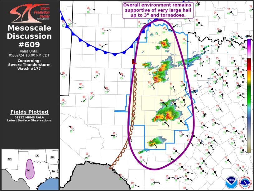
   Mesoscale Discussion 0609
   NWS Storm Prediction Center Norman OK
   0824 PM CDT Thu May 02 2024

   Areas affected...Northwest TX into Southwest TX into the TX Hill
   Country

   Concerning...Severe Thunderstorm Watch 177...

   Valid 030124Z - 030300Z

   The severe weather threat for Severe Thunderstorm Watch 177
   continues.

   SUMMARY...The environment from northwest Texas into southwest Texas
   and the Texas Hill Country remains supportive of supercells capable
   of all severe hazards, including very large hail up to 3" and
   tornadoes.

   DISCUSSION...Numerous supercells continue within Severe Thunderstorm
   Watch 177 from northwest TX into southwest TX and the TX Hill
   Country. Recent KDYX VAD sampled relatively modest low-level
   storm-relative helicity (i.e. 0-1 km SRH of 60 to 75 m2/s2) and weak
   low-level shear (i.e. 0-1 km bulk shear less than 15 kt). Even so,
   the combination of strongly deviant motion (i.e. southeastward at
   around 10 kt), ample low-level vorticity in the vicinity of the
   dryline and more localized differential heating boundaries, and
   strong low-level buoyancy (i.e. 0-3 km MLCAPE over 75 J/kg) has
   supported several different instances of tornadogenesis, both with
   the northern pair of supercells near ABI and farther south in
   Runnels and Coleman Counties.

   Overall environment remains supportive of supercells capable of all
   severe hazards, including very large hail up to 3" and tornadoes.
   New development is possible along the outflow of ongoing storms as
   well as just a bit south of the watch in the TX Hill Country. The
   onset of nocturnal stabilization will likely lead to a gradually
   diminishing tornado threat over the next two hours, but the hail
   threat will persist through the evening. A watch may be needed
   farther south if convective trends merit.

   ..Mosier.. 05/03/2024

   ...Please see www.spc.noaa.gov for graphic product...

   ATTN...WFO...FWD...OUN...EWX...SJT...LUB...

   LAT...LON   33550045 34420000 34199897 30919823 29639964 30560070
               33550045
|
|
Top/All Mesoscale Discussions/Forecast Products/Home
|
|


 @NWSSPC