|
| Mesoscale Discussion 562 |
|
< Previous MD Next MD >
|
|
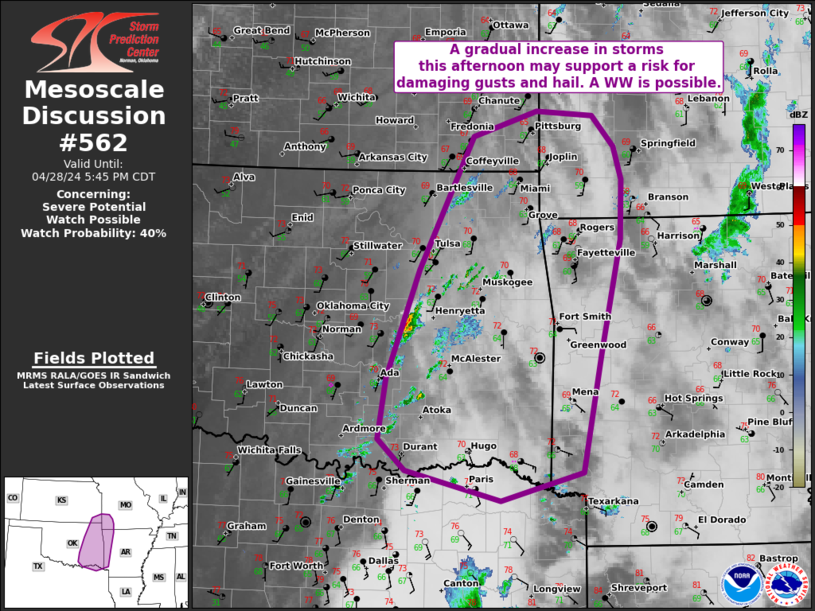
   Mesoscale Discussion 0562
   NWS Storm Prediction Center Norman OK
   0338 PM CDT Sun Apr 28 2024

   Areas affected...portions of eastern OK...western Arkansas and into
   far southeast KS and southwest MO.

   Concerning...Severe potential...Watch possible

   Valid 282038Z - 282245Z

   Probability of Watch Issuance...40 percent

   SUMMARY...Weak showers may gradually deepen into clusters of strong
   to severe storms late this afternoon. Uncertainty remains high as it
   is unclear if the air mass can recover in the wake of earlier
   storms. Trends will be monitored for a possible WW.

   DISCUSSION...As of 2030 UTC, regional radar and satellite data
   showed a few showers slowly deepening over parts of central and
   eastern OK and northeast TX. In the wake of the early day MCS
   lingering clouds have slowed diurnal heating with temperatures
   stubbornly remaining in the upper 60s to low 70s F. Still, some
   clearing has emerged and 1.25-1.4 in precipitable water values show
   sufficient moisture for deep convection. Hi-res guidance shows these
   showers may gradually deepen into several clusters of thunderstorms
   across eastern OK over the next couple of hours as a subtle
   upper-level trough moves in from the west. With 500-1000 J/kg of
   MLCAPE potential available by 22-23z, a few stronger updrafts could
   emerge. 35-45 kt of effective shear would favor storm organization,
   though in the form of a mix of cellular and cluster elements.
   Damaging gusts and isolated hail appear to be the most likely
   threats should more robust storms develop. Still, a 30-40 kt LLJ
   should enlarge low-level hodographs near sunset to support the risk
   for a tornado or two. The primary uncertainty for this afternoon and
   evening is the coverage and intensity of storms that develop. While
   it remains unclear now, conditions are being monitored for a
   possible watch.

   ..Lyons/Hart.. 04/28/2024

   ...Please see www.spc.noaa.gov for graphic product...

   ATTN...WFO...LZK...SGF...SHV...TSA...ICT...FWD...OUN...

   LAT...LON   33509512 33829634 34159670 34809659 35959618 37379548
               37639464 37599391 37259363 36909353 36269355 35059382
               33799406 33509512
|
|
Top/All Mesoscale Discussions/Forecast Products/Home
|
|


 @NWSSPC