|
| Mesoscale Discussion 212 |
|
< Previous MD Next MD >
|
|
Mesoscale Discussion 0212
NWS Storm Prediction Center Norman OK
1252 PM CST Sat Mar 09 2024
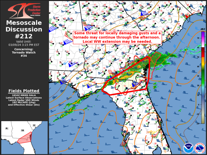
Areas affected...North FL into southeast GA
Concerning...Tornado Watch 34...
Valid 091852Z - 092015Z
The severe weather threat for Tornado Watch 34 continues.
SUMMARY...Some threat for locally damaging gusts and a tornado or
two may continue through the afternoon. Local extension of WW 34 may
be needed.
DISCUSSION...A broken line of storms with embedded supercell
structures is ongoing at 1845 UTC from southeast GA into north FL.
While some gradual veering of low-level flow has been noted with
time, moderate buoyancy (MLCAPE of 1000-1500 J/kg) and rather strong
low-level (with 0-1 km SRH of 150-250 m2/s2) and deep-layer shear
continue to be supportive of organized convection. Occasional
embedded supercell structures continue to be noted, and some threat
for a tornado or two may persist through much of the afternoon,
especially with the supercell currently over Brantley County, GA.
Otherwise, locally damaging gusts will remain possible with the
strongest storms, especially in areas where stronger heating and
steepening of low-level lapse rates have been observed.
While an eventual weakening trend is expected as stronger
large-scale ascent moves away from the region, some severe threat
will persist beyond the 2 PM EST expiration time of WW 34. As a
result, local watch extension may be needed to address the threat
through late afternoon.
..Dean/Smith.. 03/09/2024
...Please see www.spc.noaa.gov for graphic product...
ATTN...WFO...CHS...JAX...TAE...
LAT...LON 30128145 29828355 30028400 30408380 30538369 31468191
31778134 31698121 31108123 30608129 30128145
|
|
Top/All Mesoscale Discussions/Forecast Products/Home
|
|


 @NWSSPC