|
| Mesoscale Discussion 54 |
|
< Previous MD Next MD >
|
|
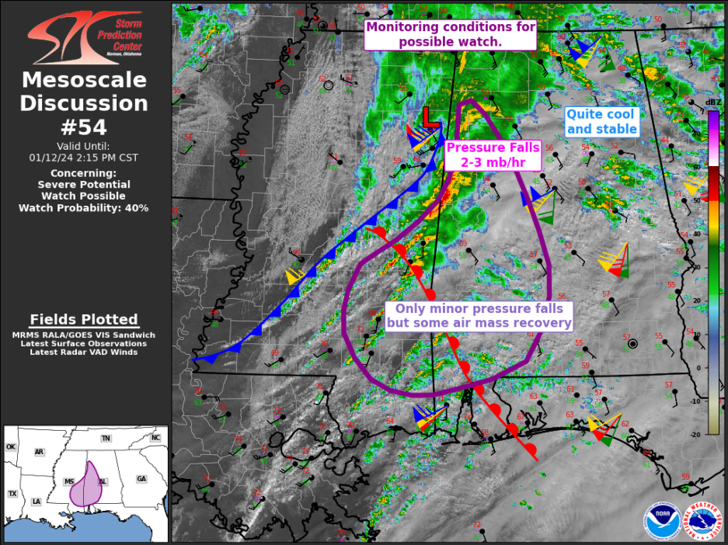
   Mesoscale Discussion 0054
   NWS Storm Prediction Center Norman OK
   1011 AM CST Fri Jan 12 2024

   Areas affected...southern Mississippi into Alabama

   Concerning...Severe potential...Watch possible

   Valid 121611Z - 122015Z

   Probability of Watch Issuance...40 percent

   SUMMARY...The area from southern and eastern Mississippi into
   western and southern Alabama is being monitored for watch potential.

   DISCUSSION...A low continues to deepen near the MS/AL border with
   associated thunderstorm line segments. This area of storms near the
   low has been producing 35-45 kt winds consistently. The air mass to
   the east becomes progressively more stable with cooler temperatures
   and lower dewpoints. Therefore, a ramp up in storm intensity is not
   anticipated over much of northern AL.

   Farther south, a warm front intersects the main cold front over
   east-central MS, with better moisture spreading northward into
   southwest AL and southern MS. Showers are developing in the warm
   advection zone, but instability is generally below 1000 J/kg.

   It is uncertain how much severe activity will occur over the next
   few hours as the upper wave lifts north of the area, veering
   low-level winds over the small warm sector and with limited lift.
   Warm sector trends will continue to be monitored as destabilization
   occurs into southern AL where lift along the warm front could
   support a few severe storms.

   ..Jewell/Thompson.. 01/12/2024

   ...Please see www.spc.noaa.gov for graphic product...

   ATTN...WFO...BMX...MOB...JAN...

   LAT...LON   32308941 32578894 33038836 33568812 34148808 34198791
               34038771 33468732 32698699 32298686 31938686 31188718
               30858812 30798870 30968926 31508963 32008958 32308941
|
|
Top/All Mesoscale Discussions/Forecast Products/Home
|
|


 @NWSSPC