|
| Mesoscale Discussion 39 |
|
< Previous MD Next MD >
|
|
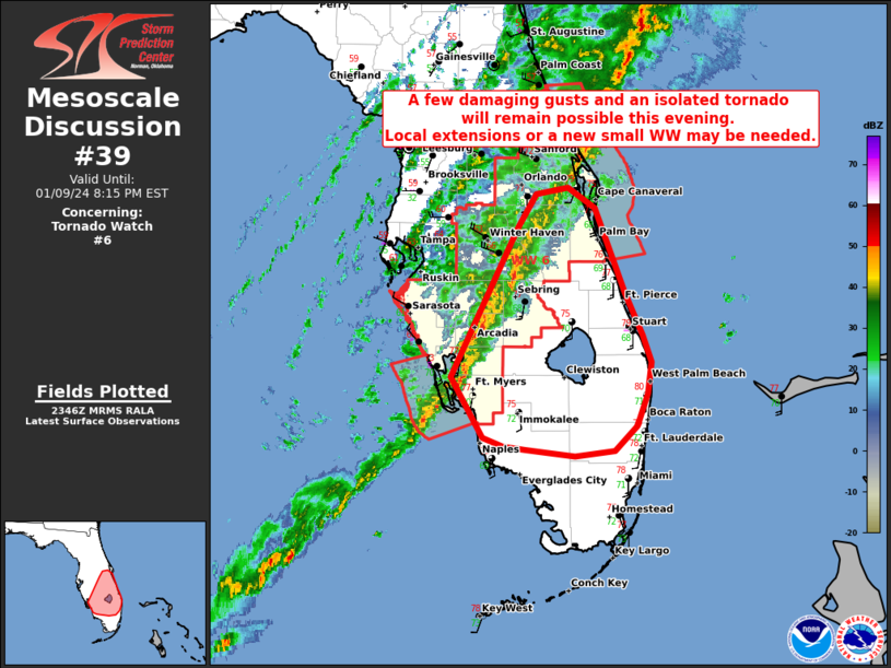
   Mesoscale Discussion 0039
   NWS Storm Prediction Center Norman OK
   0548 PM CST Tue Jan 09 2024

   Areas affected...portions of central and southern Florida

   Concerning...Tornado Watch 6...

   Valid 092348Z - 100115Z

   The severe weather threat for Tornado Watch 6 continues.

   SUMMARY...Ongoing QLCS will likely persist into this evening. Strong
   wind profiles will support continued storm organization with a risk
   for damaging gusts and isolated tornadoes. Local extension of WW6 or
   a new small watch may be needed farther south.

   DISCUSSION...As of 2345, the environment ahead of the ongoing QLCS
   over central Florida remains moderately unstable and strongly
   sheared. This should continue to support organized storms over
   south-central Florida into this evening. A few stronger elements
   have been noted within the broader QLCS with the potential for
   damaging gusts owing to the strong background wind fields. 0-1km srh
   of 300-400 m2/s2 from area VADS also suggest isolated tornadoes will
   remain possible with the more organized parts of the QLCS.

   Farther south, large-scale ascent will gradually weaken as the upper
   trough lifts away to the north through the evening resulting in more
   veered surface flow. However, relatively strong shear will likely
   remain in place into parts of South Florida. At least some severe
   risk may persist for a few hours tonight. A local extension of WW6
   or a new small weather watch may be needed to cover the remainder of
   the severe risk before storms begin to weaken and move offshore
   overnight.

   ..Lyons/Thompson.. 01/09/2024

   ...Please see www.spc.noaa.gov for graphic product...

   ATTN...WFO...MFL...MLB...TBW...

   LAT...LON   26748210 28148140 28458121 28518088 28328061 27528029
               27148011 26888002 26598007 26298017 26068040 26028081
               26088132 26118155 26198176 26748210
|
|
Top/All Mesoscale Discussions/Forecast Products/Home
|
|


 @NWSSPC