|
| Mesoscale Discussion 2076 |
|
< Previous MD Next MD >
|
|
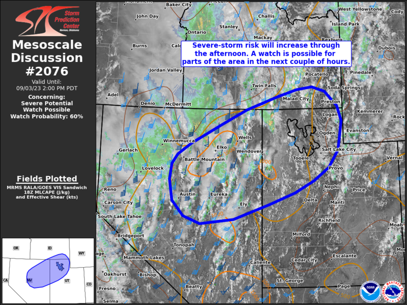
   Mesoscale Discussion 2076
   NWS Storm Prediction Center Norman OK
   0132 PM CDT Sun Sep 03 2023

   Areas affected...Central into northeast NV...northwest UT...and far
   southeast ID

   Concerning...Severe potential...Watch possible

   Valid 031832Z - 032100Z

   Probability of Watch Issuance...60 percent

   SUMMARY...Severe-storm risk will increase from west to east this
   afternoon, with severe gusts and hail possible. A watch is possible
   in the next couple of hours.

   DISCUSSION...Latest regional radar data shows a swath of convection
   with several embedded/transient deeper cores spreading northward
   across the northern half of NV this afternoon. This activity is
   generally focused near a north/south-oriented surface
   trough/stationary front and within an area of maximized
   DCVA/midlevel ascent (evident in water vapor imagery) preceding a
   substantial midlevel trough over northern CA/OR.

   As the midlevel trough and related height falls gradually spread
   eastward across eastern NV and eventually UT through the afternoon
   and evening, scattered to numerous thunderstorms will spread/expand
   east-northeastward across the region. Filtered heating and related
   destabilization of a very moist air mass across the northern half of
   NV, coupled with a long/straight hodograph (40-50 kt of effective
   shear), will support a mix of organized clusters/line segments and
   supercell structures. Severe gusts are the primary concern with this
   activity, though instances of severe hail are also possible --
   especially with any sustained supercell structures. With time,
   thunderstorms should increase in both intensity and coverage as they
   spread/develop east-northeastward into northwest UT this
   afternoon/evening -- in concert with the ejecting midlevel trough.
   Here, less cloud coverage and stronger diurnal heating may
   eventually support a relatively higher severe-wind threat, as storms
   intercept an increasingly mixed boundary layer amid favorable
   deep-layer shear.

   A watch is possible for parts of the area in the next couple of
   hours.

   ..Weinman/Guyer.. 09/03/2023

   ...Please see www.spc.noaa.gov for graphic product...

   ATTN...WFO...SLC...PIH...BOI...LKN...REV...

   LAT...LON   41581549 41021665 40721713 40441735 40011742 39421731
               38981690 38771628 38901508 39331378 39641285 39971215
               40341161 40831125 41641109 42071124 42471169 42611216
               42541273 42351345 41971461 41581549
|
|
Top/All Mesoscale Discussions/Forecast Products/Home
|
|


 @NWSSPC