|
| Mesoscale Discussion 2029 |
|
< Previous MD Next MD >
|
|
Mesoscale Discussion 2029
NWS Storm Prediction Center Norman OK
0452 AM CST Wed Dec 14 2022
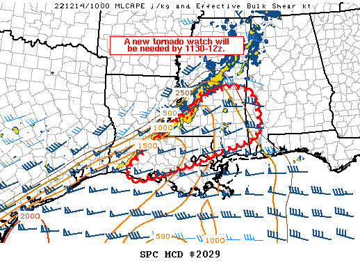
Areas affected...portions of southern LA/MS into far southwest AL
Concerning...Severe potential...Watch likely
Valid 141052Z - 141215Z
Probability of Watch Issuance...95 percent
SUMMARY...A risk for tornadoes and damaging gusts will
continue/spread east across parts of southern LA/MS and far
southwest AL this morning, and a new watch will be needed.
DISCUSSION...A line of convection continues to slowly percolate
eastward ahead of a slow-moving cold front early this morning. A
warm front extends northwest to southeast from central MS toward the
Mobile Bay vicinity. The warm front is expected to very gradually
lift northward across southwest AL through the morning hours. The
wedge of warm sector air between the eastward-advancing line of
convection and the warm front is characterized by upper 60s to low
70s surface dewpoints, contributing to modest instability. Regional
VWP data continues to indicate strong low-level shear and favorably
curved hodographs. Periodic rotation in line-embedded cells
continues early this morning across southwest MS into southwest LA.
Additionally, a band of showers and isolated thunderstorms
developing within low-level confluence ahead of the main line of
convection across southeast MS has shown increasing intensity and at
least modest rotation over the past hour or two.
Given the overlap of favorable low-level instability and strong
vertical shear, a risk for tornadoes and damaging gusts is expected
to continue eastward this morning. A new tornado watch will be
needed across parts of southern LA/MS into far southwest AL.
..Leitman/Edwards.. 12/14/2022
...Please see www.spc.noaa.gov for graphic product...
ATTN...WFO...BMX...MOB...JAN...LIX...LCH...
LAT...LON 30209265 31289146 32468980 32638907 32568850 32308816
31958804 31438797 30938811 30728881 30438980 30169045
30049087 29889139 29589248 29599290 29889300 30209265
|
|
Top/All Mesoscale Discussions/Forecast Products/Home
|
|


 @NWSSPC