|
| Mesoscale Discussion 2210 |
|
< Previous MD Next MD >
|
|
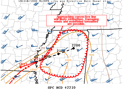
   Mesoscale Discussion 2210
   NWS Storm Prediction Center Norman OK
   0152 PM CST Mon Dec 16 2019

   Areas affected...Northern/Central MS

   Concerning...Severe potential...Tornado Watch likely

   Valid 161952Z - 162115Z

   Probability of Watch Issuance...80 percent

   SUMMARY...Convective line approaching northern/central MS is
   expected to strengthen as it continues eastward. Damaging wind gusts
   and embedded QLCS tornadoes are possible. A Tornado Watch will be
   needed soon.

   DISCUSSION...Recent radar imagery shows a convective line stretching
   from OLV along the MS/TN border southwestward into northern LA. The
   downstream air mass continues to destabilize and recent trends
   within this radar imagery suggest the intensity of this convective
   line is strengthening (evidenced by both increasing storm speed and
   higher echo tops) especially near the AR/LA/MS border intersection.
   Vertical shear is expected to remain strong and the approaching
   shortwave trough will provide increased large-scale forcing for
   ascent. All of these factors suggest the ongoing line will
   strengthen as it continues eastward in northern/central MS. Primary
   severe threat is expected to be damaging wind gusts, but the
   strengthening low-level winds and persisting deep-layer shear
   suggest there is also a threat for embedded QLCS tornadoes. A
   Tornado Watch will be needed soon to cover this potential severe
   threat.

   ..Mosier/Grams.. 12/16/2019

   ...Please see www.spc.noaa.gov for graphic product...

   ATTN...WFO...MEG...JAN...

   LAT...LON   34438997 34898955 34948864 34598824 33878832 32848892
               33169080 34438997
|
|
Top/All Mesoscale Discussions/Forecast Products/Home
|
|


 @NWSSPC