|
| Mesoscale Discussion 615 |
|
< Previous MD Next MD >
|
|
Mesoscale Discussion 0615
NWS Storm Prediction Center Norman OK
0602 PM CDT Fri Jun 01 2018
Areas affected...Portions of western/central ND
Concerning...Tornado Watch 146...
Valid 012302Z - 020030Z
The severe weather threat for Tornado Watch 146 continues.
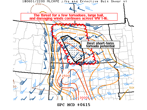
SUMMARY...The threat for a few tornadoes, large hail, and damaging
winds continues across WW 146.
DISCUSSION...RAP mesoanalysis shows a surface low over central SD,
with surface troughing extending northward from this low across
south-central into western ND. A band of thunderstorms has recently
formed along the surface trough in western/south-central ND. A
narrow corridor of surface heating has occurred ahead of this
convection mainly across central ND, and a reservoir of relatively
better low-level moisture is also present over this area.
Southeasterly low-level winds quickly veering and strengthening with
height to southwesterly at mid levels are resulting in effective
bulk shear values of 40-50 kt. Supercell structures have been noted
with the line of thunderstorms, and given the sufficient instability
and strong shear, large hail and damaging winds will continue to be
a threat. Pronounced low-level hodograph curvature noted in both the
KBIS and KMBX VWPs is supporting effective SRH values of 350-500+
m2/s2. Tornadoes will be possible with any sustained, rotating
updraft embedded within the line given the magnitude of the
low-level shear and vertical vorticity present along the boundary.
In the short-term, the best tornado potential would seem to be
focused along and just northeast of the line. Continued
consolidation of the line would suggest an eventual transition to a
greater wind threat through the evening hours.
..Gleason.. 06/01/2018
...Please see www.spc.noaa.gov for graphic product...
ATTN...WFO...BIS...
LAT...LON 45990193 46600202 47480288 48230400 48940398 48950021
47839989 45969901 45990193
|
|
Top/All Mesoscale Discussions/Forecast Products/Home
|
|


 @NWSSPC