|
| Mesoscale Discussion 995 |
|
< Previous MD Next MD >
|

|
   Mesoscale Discussion 0995
   NWS Storm Prediction Center Norman OK
   1229 PM CDT Mon Jun 12 2017

   Areas affected...Portions of eastern Wyoming...northeast
   Colorado...western Nebraska and southwest South Dakota

   Concerning...Severe potential...Tornado Watch likely

   Valid 121729Z - 121930Z

   Probability of Watch Issuance...95 percent

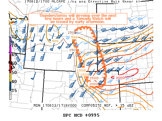
   SUMMARY...Potentially rapid development of severe thunderstorms
   including supercells is expected by early-mid afternoon.  Tornadoes,
   some potentially strong, along with very large hail and damaging
   winds will be possible.  A Tornado Watch will be issued by early
   afternoon.

   DISCUSSION...Surface observational trends show a very moist upslope
   low-level flow across the discussion area at 17z with surface dew
   points in the mid 50s-lower 60s. Breaks in cloud cover are allowing
   for steady diurnal heating and moderate/strong surfaced-based
   buoyancy is expected to be in place by early-mid afternoon. Latest
   visible imagery depicts a few towering cumulus clouds along the west
   edge of the deeper moisture across central Wyoming, and thunderstorm
   development will become likely over the next couple of hours with
   continued heating/low-level upslope flow and large-scale ascent in
   advance of an upper low over Nevada. Strengthening mid-level flow
   will result in deep-layer shear of 50-60 kts across the area,
   favoring supercell structures as the initial storm mode. Very steep
   mid-level lapse rates will be favorable for very large hail, and
   increasing low-level winds with time will result in long hodographs
   with substantial low-level curvature/low-level SRH.  Given this
   setup, strong tornadoes will be possible this afternoon.

   Given recent observational trends, a Tornado Watch will be needed
   early this afternoon.

   ..Bunting/Hart.. 06/12/2017

   ...Please see www.spc.noaa.gov for graphic product...

   ATTN...WFO...UNR...BOU...CYS...RIW...

   LAT...LON   40040353 39930458 41130525 42660595 43540635 43990604
               44160514 44020466 43240422 42230379 40920334 40040353
|
|
Top/All Mesoscale Discussions/Forecast Products/Home
|
|


