|
| Mesoscale Discussion 854 |
|
< Previous MD Next MD >
|
|
MESOSCALE DISCUSSION 0854
NWS STORM PREDICTION CENTER NORMAN OK
0109 PM CDT SUN MAY 22 2011
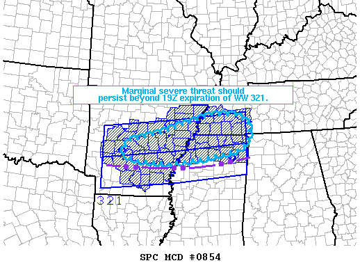
AREAS AFFECTED...CNTRL/ERN AR...NRN MS...SWRN TN
CONCERNING...SEVERE THUNDERSTORM WATCH 321...
VALID 221809Z - 221915Z
THE SEVERE WEATHER THREAT FOR SEVERE THUNDERSTORM WATCH 321
CONTINUES.
WW 321 IS SCHEDULED TO EXPIRE AT 19Z AND THE NEED FOR A WW
REPLACEMENT REMAINS UNCLEAR. LOW-LEVEL WARM THETA-E ADVECTION WILL
CONTINUE ATOP A WEST/EAST-ORIENTED OUTFLOW BOUNDARY STRETCHING FROM
30 N TXK TO 25 S TUP AT 18Z. THIS WILL FAVOR TSTM REGENERATION
ACROSS THE MS VALLEY THROUGH AT LEAST MID-AFTERNOON. GIVEN EFFECTIVE
SHEAR OF 30 TO 4O KT...A THREAT FOR MARGINALLY SEVERE HAIL AND
LOCALIZED MICROBURSTS SHOULD PERSIST WITHIN STRONGER CORES.
..GRAMS.. 05/22/2011
ATTN...WFO...HUN...MEG...JAN...LZK...
LAT...LON 34369300 34759292 35069152 35658958 35638852 35338805
34878812 34528846 34248990 34089123 34179257 34369300
|
|
Top/All Mesoscale Discussions/Forecast Products/Home
|
|


 @NWSSPC