Skip Navigation Links weather.gov 
NOAA logo-Select to go to the NOAA homepage NOAA's National Weather Service   Select to go to the NWS homepage
Storm Prediction Center
navigation bar left  
  navigation bar end cap


USA.gov is the U.S. Government's official Web portal to all Federal, state and local government Web resources and services.

Mesoscale Discussion 996
< Previous MD          Next MD >
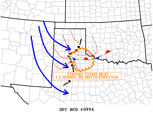
MD 996 graphic
   
   MESOSCALE DISCUSSION 0996
   NWS STORM PREDICTION CENTER NORMAN OK
   1113 PM CDT SUN JUN 03 2007
   
   AREAS AFFECTED...TX OK
   
   CONCERNING...SEVERE POTENTIAL...WATCH UNLIKELY 
   
   VALID 040413Z - 040615Z
   
   SLOW MOVING AND MARGINALLY ORGANIZED MCS MOVING SLOWLY ESEWD ACROSS 
   SWISHER AND HALE COUNTIES IN TX. SYSTEM APPEARS TO HAVE FORMED WEAK
   MESOLOW AND LIFT ASSOCIATED WITH THIS FEATURE SHOULD MAINTAIN THE
   CHANCE FOR TSTMS EWD INTO NWRN TX LATE TONIGHT. MARGINAL INSTABILITY
   AND SHEAR ARE EXPECTED TO LIMIT SEVERE POTENTIAL AND A WATCH IS NOT
   LIKELY.
   
   ..CARBIN.. 06/04/2007
   
   
   ATTN...WFO...OUN...LUB...AMA...
   
   33460089 33880106 34450150 34730073 34990035 34689973
   34189943 33739937 33340043 
   
Top/All Mesoscale Discussions/Forecast Products/Home
Weather Topics:
Watches, Mesoscale Discussions, Outlooks, Fire Weather, All Products, Contact Us

NOAA / National Weather Service
National Centers for Environmental Prediction
Storm Prediction Center
120 David L. Boren Blvd.
Norman, OK 73072 U.S.A.
spc.feedback@noaa.gov
Page last modified: January 01, 1970
Disclaimer
Information Quality
Help
Glossary
Privacy Policy
Freedom of Information Act (FOIA)
About Us
Career Opportunities