|
| Mesoscale Discussion 575 |
|
< Previous MD
Next MD >
|
|
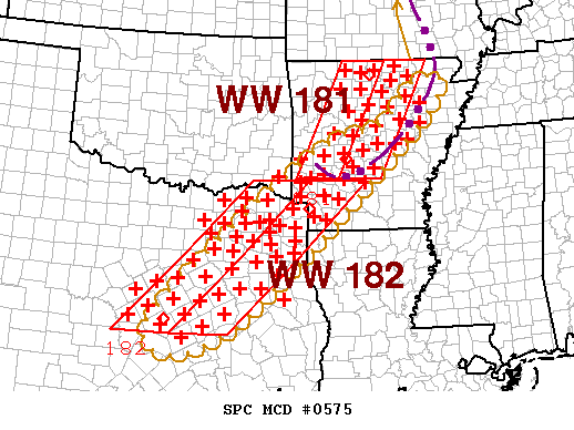
   MESOSCALE DISCUSSION 0575
   NWS STORM PREDICTION CENTER NORMAN OK
   1158 PM CDT TUE APR 24 2007

   AREAS AFFECTED...PORTIONS SRN AR...CENTRAL/NERN TX.

   CONCERNING...TORNADO WATCH 181...182...

   VALID 250458Z - 250630Z

   THE SEVERE WEATHER THREAT FOR TORNADO WATCH 181...182...CONTINUES.

   TSTMS ARE FCST TO CONTINUE MOVING GENERALLY EWD ACROSS WWS WITH SOME
   POTENTIAL FOR ADDITIONAL DEVELOPMENT OF BOW ECHOES...AND ASSOCIATED
   DAMAGING GUSTS.  TORNADO POTENTIAL STILL CANNOT BE RULED OUT GIVEN
   1. STRENGTH OF LOW LEVEL SHEAR -- I.E. 0-1 KM SRH 200-400 J/KG BASED
   ON VWP DATA AND MODIFIED RUC SOUNDINGS -- AS WELL AS
   2. PRESENCE OF NEARLY SFC-BASED BUOYANCY LINGERING IN PRE-STORM
   INFLOW LAYER...WITH SFC TEMPS LOW-MID 70S F AND DEW POINTS LOW-MID
   60S CONTRIBUTING TO MLCAPE 1000-1500 J/KG.

   ..EDWARDS.. 04/25/2007


   ATTN...WFO...MEG...LZK...SHV...HGX...FWD...

   34579389 35119221 36089126 35589079 30939590 30979785
|
|
Top/All Mesoscale Discussions/Forecast Products/Home
|
|


 @NWSSPC