Storm Prediction Center Day 1 Fire Weather Outlook
Created: Fri Mar 31 14:16:03 UTC 2023 (
![]() |
| ![]() )
)
|
Click for Day 1 FireWX Areal Outline Product
ZCZC SPCFWDDY1 ALL
FNUS21 KWNS 311415
Day 1 Fire Weather Outlook
NWS Storm Prediction Center Norman OK
0915 AM CDT Fri Mar 31 2023
Valid 311700Z - 011200Z
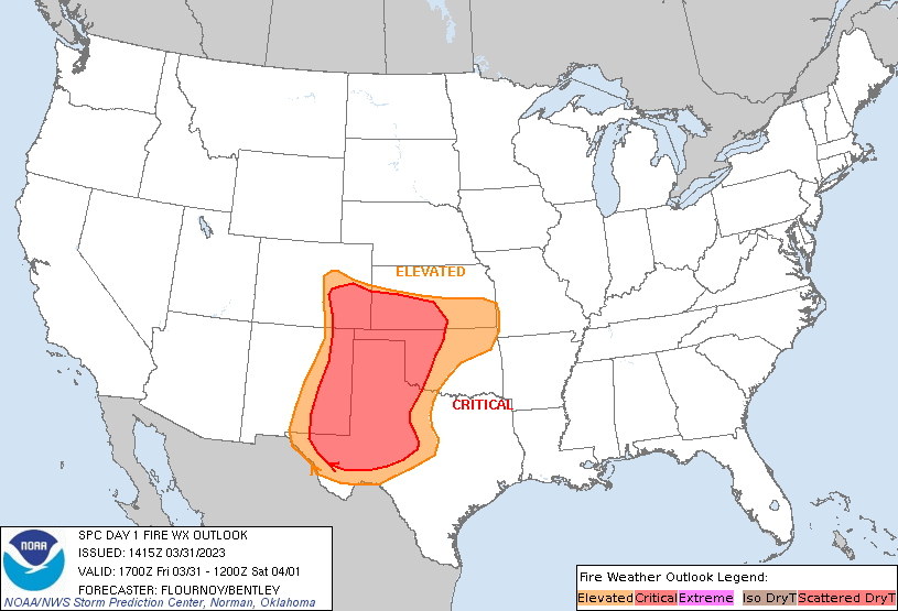
...CRITICAL FIRE WEATHER AREA FOR PORTIONS OF THE CENTRAL/SOUTHERN
PLAINS...
The previous forecast remains on track regarding widespread,
high-end critical fire-weather conditions developing this afternoon
in portions of the Central/Southern Plains. No changes were made to
the Elevated/Critical areas. Although fuels do not support a
delineated area, the greatest chance for Extremely Critical
meteorological conditions (relative humidities around 5-10 percent
and sustained winds around 30 mph) will extend from the OK/TX
Panhandles south through the Caprock and Rolling Plains. Critically
dry and windy post-frontal conditions may also develop farther east
across southeastern KS and central OK. Moister fuels and some
overnight precipitation -- especially south of the I-44 corridor --
lessen the overall threat here, but an increase in initial attack is
possible.
..Flournoy/Bentley.. 03/31/2023
.PREV DISCUSSION... /ISSUED 0115 AM CDT Fri Mar 31 2023/
...Synopsis...
A deepening surface low will track northeast across the Central/High
Plains with an attendant cold front tracking eastward across the
Plains into the Ohio and Mississippi River Valleys on Friday. Behind
the cold front, clearing skies are expected with a broad region of
strong westerly flow and relative humidity reductions creating
Elevated to Critical Fire weather conditions across portions of the
Central and Southern Plains.
...Central and Southern Plains...
Strong downslope warming and drying is expected across eastern
Colorado and eastern New Mexico into western Texas, Oklahoma, and
Kansas. Relative humidity reductions to 15-20 percent with sustained
westerly winds 25-35 mph will be likely, supporting a Critical
delineation. This area was expanded to reflect recent HREF guidance
and lack of meaningful rainfall across western Kansas and Oklahoma
on Thursday. Relative humidity could drop as low as 10 percent
across some portion of this region, which would suggest corridors of
Extremely Critical fire weather conditions are possible. HREF
conditional probabilities highlight the most likely region for
Extremely Critical conditions to occur across southwestern Texas
into the Oklahoma Panhandle. Fuels in this region do not support
including an Extremely Critical area at this time, given ERCs
largely around the 60-70th percentile. Even so, this scenario
remains a high-end Critical fire weather situation.
Elevated conditions will extend into eastern Oklahoma and Kansas.
Fuels within this region are less supportive of fire spread due to
recent rainfall. Even so, dry and gusty conditions Friday will
support some response in fine fuels and potential for increased risk
of fire spread.
...Please see www.spc.noaa.gov/fire for graphic product...