Storm Prediction Center Day 1 Fire Weather Outlook
Created: Wed Sep 2 16:54:02 UTC 2020 (
![]() |
| ![]() )
)
|
Click for Day 1 FireWX Areal Outline Product
ZCZC SPCFWDDY1 ALL
FNUS21 KWNS 021653
Day 1 Fire Weather Outlook
NWS Storm Prediction Center Norman OK
1153 AM CDT Wed Sep 02 2020
Valid 021700Z - 031200Z
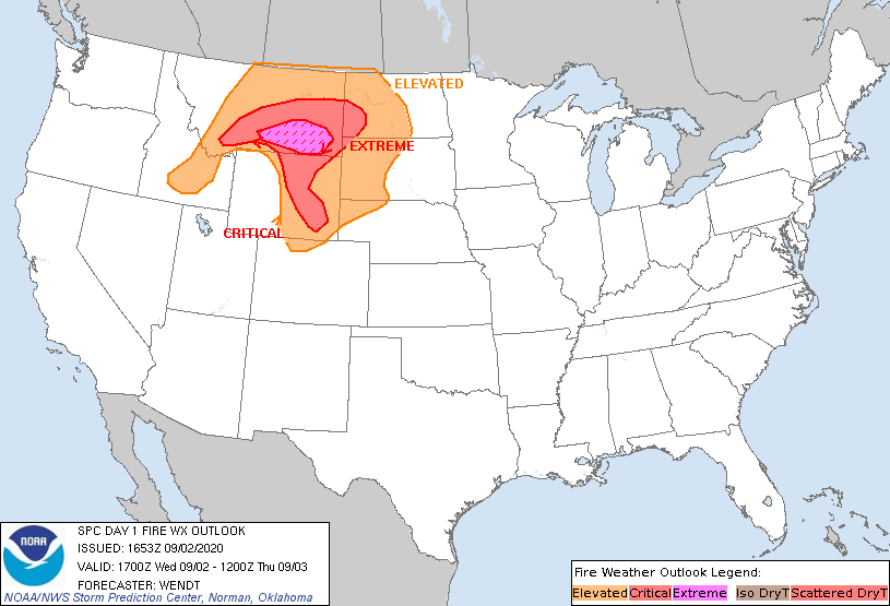
...EXTREMELY CRITICAL FIRE WEATHER AREA FOR SOUTH-CENTRAL AND
SOUTHEASTERN MONTANA...
...CRITICAL FIRE WEATHER AREA FOR PORTIONS OF SOUTHERN
MONTANA...SOUTHWESTERN NORTH DAKOTA...PORTIONS OF CENTRAL AND
EASTERN WYOMING...
Only minor modifications have been made to the elevated area on
account of current surface observations. Areas of 20-35 mph winds
with gusts into 25-45 mph range are already being observed in
Montana this morning. Significant fire weather conditions are still
expected to develop this afternoon across south-central and
southeastern Montana.
See the previous discussion for further forecast details.
..Wendt.. 09/02/2020
.PREV DISCUSSION... /ISSUED 0145 AM CDT Wed Sep 02 2020/
...Synopsis...
A strong shortwave trough will move southward across the northern
U.S. as a ridge of high pressure begins to build over the West. A
deepening area of low pressure will drag a dry cold front
southeastward across the northern Rockies and adjacent plains
bringing very strong winds and low humidity. Extremely critical fire
weather conditions appear likely.
...Southern Montana...
Critical and extremely critical fire weather conditions are likely
to develop this afternoon ahead of the strong dry cold front moving
across the northern Rockies. Strong gradient winds associated with
the deepening low and cold front will be bolstered by surface
momentum transfer from a 70-80 kt mid-level jet along the southern
end of the shortwave trough. Model soundings show an environment
extremely favorable for rapid wind-driven fire growth/spread with
boundary-layer wind gusts in excess of 50 mph likely. Strong daytime
heating, with temperatures in the 80s and 90s F will keep surface RH
low near 10%. With adequate fuels, strong downslope flow, and dry
conditions, extremely critical fire weather conditions appear
likely. There is a significant risk of extreme wind-driven fire
behavior and blowups along and ahead of the dry front. Gusty winds
will likely persist behind the front, but increasing RH recoveries
to near 40% should limit the potential for extreme fire weather
conditions after sunset.
Into eastern Wyoming and the western Dakotas, critical fire weather
conditions are likely on the fringes of the stronger flow aloft.
While winds will be weaker, a lee trough and downward momentum
transfer should support surface winds of 20-25 mph with surface RH
below 15%. The favorable meteorological overlap with widespread
critically dry fuels justifies the inclusion of critical
probabilities.
...Lee of the Cascades...
Locally elevated fire weather conditions may develop across the
Columbia Basin and in the lee of the Cascades. The strong mid-level
jet overhead will support gusty surface winds of 20-30 mph, though
humidity values will only be marginally supportive due to cooler
temperatures behind the departing front. This suggests any fire
weather conditions will be localized in nature.
...Please see www.spc.noaa.gov/fire for graphic product...