Storm Prediction Center Day 1 Fire Weather Outlook
Created: Sun Jun 7 16:38:02 UTC 2020 (
![]() |
| ![]() )
)
|
Click for Day 1 FireWX Areal Outline Product
ZCZC SPCFWDDY1 ALL
FNUS21 KWNS 071636
Day 1 Fire Weather Outlook
NWS Storm Prediction Center Norman OK
1136 AM CDT Sun Jun 07 2020
Valid 071700Z - 081200Z
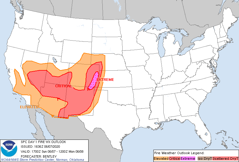
...EXTREMELY CRITICAL FIRE WEATHER AREA FOR NORTHEAST NEW MEXICO
INTO EASTERN COLORADO...
...CRITICAL FIRE WEATHER AREA FOR THE HIGH PLAINS...SOUTHWEST...AND
SOUTHERN GREAT BASIN...
No changes were made to the extremely critical area. The forecast
remains on track with winds of 30 to 35 mph expected and relative
humidity dropping below 10 percent.
Expanded the elevated area to include all of the central Rockies.
While most of this area has seen wetting rainfall with thunderstorms
over the past few weeks, there have still been some lightning
started fires and there are still some dry spots in the region.
Therefore, with winds of 20-25 mph expected and relative humidity of
15 to 35 percent, felt an elevated was warranted.
Expanded the elevated area to include all of southeastern
California. While most of this area is desert, there is some sparse
vegetation, and meteorological conditions are expected to be near
extremely critical with winds of 25 to 35 mph and relative humidity
of 4 to 12 percent.
Expanded the elevated northward into the Central Valley in
California. Dry northerly winds are expected to strengthen this
afternoon/evening with winds of 15 to 20 mph and relative humidity
of 15 to 20 percent.
Finally, combined the critical area in eastern Nevada with the
larger critical area and expanded to include southern Nevada. While
there will likely be weaker winds in the region previously between
these two critical areas, it will be very dry (5 to 10 percent
relative humidity), and winds will range from 15 to 25 mph.
..Bentley.. 06/07/2020
.PREV DISCUSSION... /ISSUED 0151 AM CDT Sun Jun 07 2020/
...Synopsis...
Broad upper-level troughing will continue over the West with an
upper low tracking from the Pacific Northwest through the northern
Rockies. A strong mid-level jet (50-65 knots) will overspread the
Intermountain West and strengthen later in the day over the northern
High Plains. A surface cold front will push southeast across the
Great Basin and through the northern Rockies with lee troughing
extending southward across the High Plains. Given recent lightning
and forecast critical/extremely critical conditions, there is
significant concern for rapid fire spread for numerous lightning
ignitions across the region.
...Southwest into central High Plains...
Extremely critical conditions are expected across far northeast New
Mexico into eastern Colorado today with south-southwest sustained
surface winds of 30-35 mph and minimum RH of 5-10%. Critical
conditions will develop across much of New Mexico into the central
High Plains amid a hot/dry airmass and in the vicinity of lee
troughing and strengthening mid-level winds. There is some
uncertainty pertaining to the eastern/northern extent of elevated
conditions.
...Great Basin to Four Corners...
Critical conditions are expected to develop along/ahead of an
approaching cold front in the Great Basin and into the Four Corners
region. Locally extremely critical conditions are possible in
northern Arizona/southern Utah. Winds will be southwesterly
along/near the prefrontal trough with westerly winds along/just
behind the cold front in the Great Basin. Wind speeds of 20-30 mph
and minimum RH of 5-15% are likely across much of the region.
Additionally, downslope winds along the eastern slopes/foothills of
the central/southern Sierra are likely to result in elevated/locally
critical conditions.
Isolated to scattered mixed wet/dry thunderstorms are likely over
portions of northern/eastern Utah, northwest Colorado, and into
southern Wyoming. While precipitable water values will be mostly
below 0.75 inch and storm motions of 30-50 knots are expected,
cooler surface temperatures and recent rainfall preclude an isolated
dry thunderstorm area.
...Southern California...
A surface pressure gradient conducive for offshore winds will set up
behind a cold frontal passage across portions of Santa Barbara,
Ventura, and Los Angeles Counties tonight into tomorrow. Elevated to
locally critical conditions are expected with north-northeasterly
winds of 15-25 mph and minimum RH of 10-20%.
...Please see www.spc.noaa.gov/fire for graphic product...