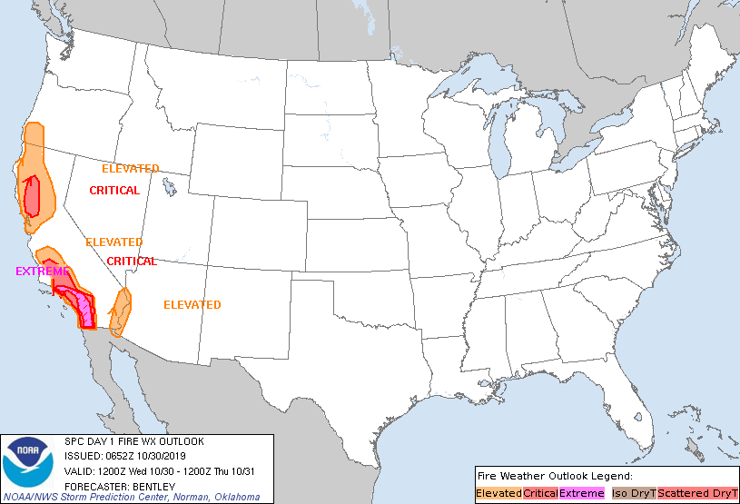
Storm Prediction Center Day 1 Fire Weather Outlook
Created: Wed Oct 30 06:53:02 UTC 2019 (
![]() |
| ![]() )
)
|
Click for Day 1 FireWX Areal Outline Product
   ZCZC SPCFWDDY1 ALL
   FNUS21 KWNS 300652

   Day 1 Fire Weather Outlook
   NWS Storm Prediction Center Norman OK
   0152 AM CDT Wed Oct 30 2019

   Valid 301200Z - 311200Z

   ...EXTREMELY CRITICAL FIRE WEATHER AREA FOR THE PENINSULAR AND
   TRANSVERSE RANGES IN SOUTHERN CALIFORNIA...
   ...CRITICAL FIRE WEATHER AREA FOR THE PENINSULAR AND TRANSVERSE
   RANGES IN SOUTHERN CALIFORNIA NORTHWARD INTO KERN COUNTY...
   ...CRITICAL FIRE WEATHER AREA FOR THE WESTERN SACRAMENTO VALLEY AND
   THE NORTH BAY AREA MOUNTAINS...

   ...Synopsis...
   Strong high pressure over the Central Rockies and lower pressure off
   the California coast will lead to continued offshore flow across
   most of California. This offshore flow will weaken somewhat during
   the afternoon hours as diurnal warming across the Great Basin
   decreases surface pressure and relaxes the gradient. However, very
   cold temperatures are expected in the Great Basin and central
   Rockies again tonight which will lead to some strengthening of the
   pressure gradient and possibly a return to extremely critical fire
   weather conditions.

   ...Northern California...
   Widespread critical fire weather conditions (20-30 mph sustained
   winds and RH 8-15 percent) are ongoing in northern California early
   this morning with a few sites reporting locally extremely critical
   conditions (primarily at high elevations). Similar conditions are
   expected through at least the morning hours today before winds start
   to weaken. Elevated winds are expected to persist through most of
   the day with relative humidity in the 5 to 12 percent range.

   ...Southern California...
   The gradient is starting to strengthen early this morning with the
   LAX-DAG gradient currently up to around 3.5mb as of 06Z. Therefore,
   strengthening offshore flow is expected to begin in the next few
   hours and strengthen rapidly toward morning. The gradient is
   expected to peak around 15Z at or above 10mb. This record or near
   record October offshore gradient, combined with some upper-level
   support will lead to very strong sustained winds of 30 to 50 mph
   with gusts 80+ mph. In addition, relative humidity will be in the 5
   to 10 percent range.

   ...The Lower Colorado River Valley...
   Northerly winds of 20 to 30 mph with gusts to 45 mph are expected in
   the Colorado River Valley today with relative humidity in the 10 to
   15 percent range. Most fuels across the region are irrigated which
   will significantly lower the fire weather threat, but an elevated
   fire weather area is justified given the solid critical
   meteorological conditions.

   ..Bentley.. 10/30/2019

   ...Please see www.spc.noaa.gov/fire for graphic product...