Storm Prediction Center Day 1 Fire Weather Outlook
Created: Fri Oct 11 06:27:03 UTC 2019 (
![]() |
| ![]() )
)
|
Click for Day 1 FireWX Areal Outline Product
ZCZC SPCFWDDY1 ALL
FNUS21 KWNS 110626
Day 1 Fire Weather Outlook
NWS Storm Prediction Center Norman OK
0126 AM CDT Fri Oct 11 2019
Valid 111200Z - 121200Z
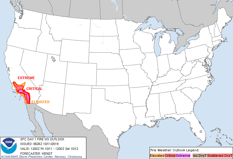
...EXTREMELY CRITICAL FIRE WEATHER AREA FOR MUCH OF THE TRANSVERSE
AND PENINSULAR RANGES AND VICINITY...
...CRITICAL FIRE WEATHER AREA FOR MUCH OF THE TRANSVERSE AND
PENINSULAR RANGES AND VICINITY...
...Synopsis...
As the upper-level trough centered over the central/northern High
Plains continues its progression eastward, the upper-level ridge
across the West Coast is forecast to de-amplify during the period.
At the surface, a strong high pressure system over the
central/northern Rockies will begin to weaken early in the period an
throughout the remainder of the day.
...Southern California...
The 06Z surface observations across southern California show
extremely low RH -- widespread values below 10% and several readings
at or below 5% within the higher terrain. The only exceptions are
some areas near the coast. Winds within the portions of the
Transverse/Peninsular Ranges remain at 20-35 mph with higher gusts,
some still at or above 50 mph. The LAX/TPH and LAX/DAG pressure
gradient observations are currently stronger than guidance has
forecast with most guidance suggesting that these gradients will
peak early in the period. With the potential for widespread RH at or
below 5% and surface winds of 15-30 mph (gusts of 40-70 mph),
extremely critical fire weather conditions are expected to occur
during the morning hours. Extremely critical conditions are expected
to reach as far south as the Laguna Mountains today. By late
morning/early afternoon, the worst of the conditions are expected to
subside; however, critical fire weather is expected to continue
through much of the afternoon. Thereafter, the offshore pressure
gradient will diminish such that elevated to locally critical
conditions will remain, particularly in the higher terrain. These
conditions will exacerbate ongoing fires in Los Angeles, Ventura,
and Riverside Counties.
...Northern California...
Current surface observations depict elevated to locally critical
conditions in a few areas along the western slopes of the Sierra.
Similar conditions may continue through the beginning of the period.
However, these conditions are expected to remain spatially confined
and confidence is low on their persistence more than an hour or two
into the period.
..Wendt.. 10/11/2019
...Please see www.spc.noaa.gov/fire for graphic product...