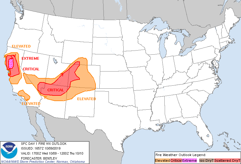
Storm Prediction Center Day 1 Fire Weather Outlook
Created: Wed Oct 9 16:58:02 UTC 2019 (
![]() |
| ![]() )
)
|
Click for Day 1 FireWX Areal Outline Product
   ZCZC SPCFWDDY1 ALL
   FNUS21 KWNS 091657

   Day 1 Fire Weather Outlook
   NWS Storm Prediction Center Norman OK
   1157 AM CDT Wed Oct 09 2019

   Valid 091700Z - 101200Z

   ...EXTREMELY CRITICAL FIRE WEATHER AREA FOR PORTIONS OF THE WESTERN
   SACRAMENTO VALLEY INTO THE NORTHERN COAST RANGES...
   ...CRITICAL FIRE WEATHER AREA FOR THE SACRAMENTO VALLEY...NORTHERN
   COAST RANGES AND SIERRA NEVADA FOOTHILLS...
   ...CRITICAL FIRE WEATHER AREA FOR SOUTHERN NEVADA...NORTHERN
   ARIZONA...SOUTHERN/EASTERN UTAH AND WESTERN COLORADO...

   Expanded the critical area north and eastward in western Colorado
   and into far southern Wyoming where high resolution guidance
   suggests critical conditions are likely and current surface
   observations are already near critical criteria. In addition,
   expanded the critical area southward in Arizona for the same
   reasons.

   The California critical/extremely critical areas appear on track
   with no changes made. 16Z surface analysis shows the pressure
   gradient has strengthened considerably over the past 6 hours  with a
   7mb gradient between Mount Shasta (KMHS) and Redding (KRDD) and this
   gradient will continue to strengthen through the day. The effects of
   this strengthening gradient can already be seen in Redding where
   winds are already around 30 mph with relative humidity less than 25
   percent. As downslope drying continues and the pressure gradient
   strengthens, these winds are only expected to increase and relative
   humidity is expected drop considerably and move southward down the
   valley through the remainder of the morning and through the
   afternoon/evening.

   ..Bentley.. 10/09/2019

   .PREV DISCUSSION... /ISSUED 0232 AM CDT Wed Oct 09 2019/

   ...Synopsis...
   A strong upper-level trough and associated surface cold front will
   move southeast over the western CONUS today. The cold front is
   expected to push into the Southwest and through much of the Rockies
   and central High Plains by tomorrow morning. A strong surface high
   will begin to establish in the northern Rockies with a strengthening
   surface pressure gradient between the Great Basin and the California
   coast resulting in strong downslope/offshore winds.

   ...northern/central California...
   Extremely critical conditions are likely to develop at times in the
   western Sacramento Valley during the afternoon into the evening with
   extremely critical conditions more likely during the
   evening/overnight across eastern portions of the northern Coast
   Ranges. North-northeasterly sustained winds of 25-35 mph with gusts
   approaching 60 mph and RH values into the single digits are likely
   within the extremely critical area. Locally extremely critical
   conditions may develop in portions of the higher terrain of
   East/South Bay and in the Sierra Nevada Foothills including
   overnight.

   North-northeasterly sustained winds of 15-30 mph with gusts of 40-50
   mph and RH values of 8-20% are expected within the elevated/critical
   areas. Elevated/critical conditions will begin late morning and
   continue into the overnight periods with the higher terrain and
   portions of the Sacramento Valley favored overnight. Fuels are
   driest in/around the Bay Area with ERCs/100-hour dead fuel moisture
   above/below the 90th/10th percentiles. However, given the expected
   winds/RH and lack of widespread precipitation this fall, fine fuels
   will be receptive to ignition/spread with some heavier fuels also
   receptive as supported by 100-hour dead fuel moisture values around
   the 80th percentile in the Sierra Nevada Foothills.

   ...southern Great Basin into the Colorado Rockies...
   Critical conditions will develop ahead of the surface cold front
   stretching from southern Nevada into northern Arizona,
   southern/eastern Utah, and western Colorado. Southwest sustained
   winds of 20-25 mph and RH values of 8-15% are expected. Elevated
   conditions will develop east of the High Sierra into southern
   Wyoming and eastern Colorado. Locally critical conditions may
   develop in southern Colorado where downslope enhancement and lee
   cyclogenesis strengthen west-southwest winds. Fuels are critically
   dry across much of Colorado with ERCs mostly above the 90th
   percentile.

   The cold front will begin to impact the delineated areas during the
   afternoon and move south/southeast through the region during the
   evening and overnight with strong north-northwest winds and a 15-30
   degree F temperature drop behind the front. Dry/windy post-frontal
   conditions in southern Nevada into the Mojave and Sonoran Deserts
   will continue overnight.

   ...southern California...
   Elevated/locally critical conditions will begin late tonight across
   portions of the Transverse Ranges in southern California. Northerly
   sustained winds of 15-20 mph with gusts of 25-35 mph and RH values
   of 10-20% are likely tonight with critical conditions likely
   beginning Thursday morning.

   ...Please see www.spc.noaa.gov/fire for graphic product...