

Day 3 Probabilistic Fire Weather Outlooks:
Probability of dry thunderstorms with dry fuels within 12 miles of a point denoted by scalloped lines for
- Critical Area - 40% (blue)
- Marginal Area - 10% (brown)
Probability of strong winds, low RH, and warm temperatures concurrent for at least 3 hours with dry fuels within 12 miles of a point denoted by solid lines for
- Critical Area - 70% (red)
- Marginal Area - 40% (orange)

Day 4 Probabilistic Fire Weather Outlooks:
Probability of dry thunderstorms with dry fuels within 12 miles of a point denoted by scalloped lines for
- Critical Area - 40% (blue)
- Marginal Area - 10% (brown)
Probability of strong winds, low RH, and warm temperatures concurrent for at least 3 hours with dry fuels within 12 miles of a point denoted by solid lines for
- Critical Area - 70% (red)
- Marginal Area - 40% (orange)

Day 5 Probabilistic Fire Weather Outlooks:
Probability of dry thunderstorms with dry fuels within 12 miles of a point denoted by scalloped lines for
- Critical Area - 40% (blue)
- Marginal Area - 10% (brown)
Probability of strong winds, low RH, and warm temperatures concurrent for at least 3 hours with dry fuels within 12 miles of a point denoted by solid lines for
- Critical Area - 70% (red)
- Marginal Area - 40% (orange)

Day 6 Probabilistic Fire Weather Outlooks:
Probability of dry thunderstorms with dry fuels within 12 miles of a point denoted by scalloped lines for
- Critical Area - 40% (blue)
- Marginal Area - 10% (brown)
Probability of strong winds, low RH, and warm temperatures concurrent for at least 3 hours with dry fuels within 12 miles of a point denoted by solid lines for
- Critical Area - 70% (red)
- Marginal Area - 40% (orange)
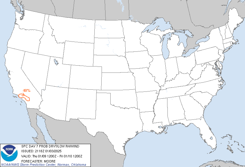
Day 7 Probabilistic Fire Weather Outlooks:
Probability of dry thunderstorms with dry fuels within 12 miles of a point denoted by scalloped lines for
- Critical Area - 40% (blue)
- Marginal Area - 10% (brown)
Probability of strong winds, low RH, and warm temperatures concurrent for at least 3 hours with dry fuels within 12 miles of a point denoted by solid lines for
- Critical Area - 70% (red)
- Marginal Area - 40% (orange)

Day 8 Probabilistic Fire Weather Outlooks:
Probability of dry thunderstorms with dry fuels within 12 miles of a point denoted by scalloped lines for
- Critical Area - 40% (blue)
- Marginal Area - 10% (brown)
Probability of strong winds, low RH, and warm temperatures concurrent for at least 3 hours with dry fuels within 12 miles of a point denoted by solid lines for
- Critical Area - 70% (red)
- Marginal Area - 40% (orange)
|
| D3 | Sun, Jan 05, 2025 - Mon, Jan 06, 2025 | D6 | Wed, Jan 08, 2025 - Thu, Jan 09, 2025 |
| D4 | Mon, Jan 06, 2025 - Tue, Jan 07, 2025 | D7 | Thu, Jan 09, 2025 - Fri, Jan 10, 2025 |
| D5 | Tue, Jan 07, 2025 - Wed, Jan 08, 2025 | D8 | Fri, Jan 10, 2025 - Sat, Jan 11, 2025 |
| (All days are valid from 12 UTC - 12 UTC) | |||
   ZCZC SPCFWDD38 ALL
   FNUS28 KWNS 032118

   Day 3-8 Fire Weather Outlook
   NWS Storm Prediction Center Norman OK
   0318 PM CST Fri Jan 03 2025

   Valid 051200Z - 111200Z

   Fire weather concerns are expected to primarily be focused along the
   southern California coast during the middle of the upcoming work
   week as a strong upper trough translates across the southwestern
   CONUS. Elsewhere, a combination of cool conditions, precipitation
   chances, and/or poor fuel status limits confidence in additional
   fire weather concerns.

   ...D5/Tue to D7/Thu - southern California Coast...
   Long-range ensemble guidance continues to depict the rapid
   amplification of an upper trough over the southern Great Basin/West
   Coast during the D5/Tue to D6/Wed time frame. A combination of an
   unseasonably strong surface high (near the 90th percentile for early
   Jan) across the northern Great Basin in the wake of the amplifying
   wave and increasing north/northeasterly mid/upper-level flow will
   promote increasing offshore winds along the southern CA coast.
   Latest deterministic solutions hint that the onset of the offshore
   flow regime may be as early as Tuesday morning and could last well
   into Thursday night with a peak in intensity sometime on Wednesday.

   This pattern is typical of past critical fire weather regimes and
   likewise will feature fire weather concerns, including the potential
   for high-end critical conditions. Global deterministic solutions
   show reasonably good agreement in the passage of the mid-level jet
   max on D6/Wed, which aligns well with recent GEFS/ECENS ensemble
   means, and will likely coincide with peak offshore winds and maximum
   downslope warming/drying. As such, confidence in critical fire
   weather conditions is sufficiently high to introduce higher, 70%
   risk probabilities for D6/Wednesday. Critical fire weather
   conditions remain possible on D5/Tue through late D7/Thu, and higher
   risk probabilities may be required in subsequent forecasts as
   confidence in the fire weather threat increases.

   ..Moore.. 01/03/2025

   ...Please see www.spc.noaa.gov/fire for graphic product...

   $$

   CLICK TO GET FNUS38 KWNS PFWF38 FIRE WEATHER OUTLOOK DAY 3-8 AREAL OUTLINE PRODUCT