Day 4-8 Severe Weather Outlook Issued on Mar 26, 2023
Updated: Sun Mar 26 08:21:03 UTC 2023
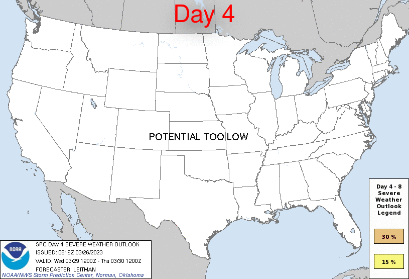
Day 4 Risk
Area (sq. mi.)
Area Pop.
Some Larger Population Centers in Risk Area
No Risk Areas Forecast
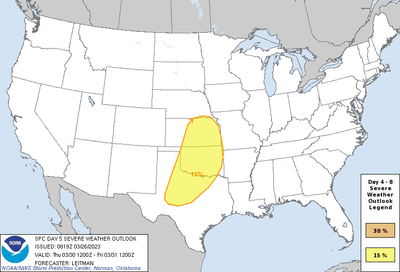
Day 5 Risk
Area (sq. mi.)
Area Pop.
Some Larger Population Centers in Risk Area
15 %
178,588
13,069,567
Dallas, TX...Fort Worth, TX...Oklahoma City, OK...Tulsa, OK...Arlington, TX...
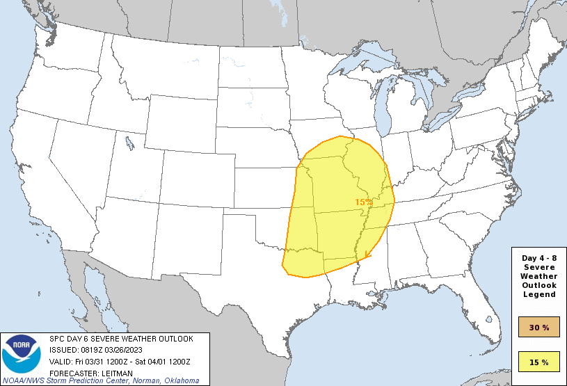
Day 6 Risk
Area (sq. mi.)
Area Pop.
Some Larger Population Centers in Risk Area
15 %
306,788
28,754,707
Dallas, TX...Memphis, TN...Fort Worth, TX...Kansas City, MO...Tulsa, OK...
Day 7 Risk
Area (sq. mi.)
Area Pop.
Some Larger Population Centers in Risk Area
No Risk Areas Forecast
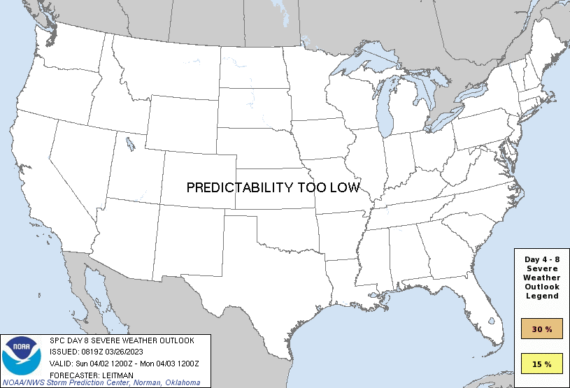
Day 8 Risk
Area (sq. mi.)
Area Pop.
Some Larger Population Centers in Risk Area
No Risk Areas Forecast
D4
Wed, Mar 29, 2023 - Thu, Mar 30, 2023
D7
Sat, Apr 01, 2023 - Sun, Apr 02, 2023
D5
Thu, Mar 30, 2023 - Fri, Mar 31, 2023
D8
Sun, Apr 02, 2023 - Mon, Apr 03, 2023
D6
Fri, Mar 31, 2023 - Sat, Apr 01, 2023
(All days are valid from 12 UTC - 12 UTC the following day)
Note: A severe weather area depicted in the Day 4-8 period indicates 15%, 30% or higher probability for severe thunderstorms within 25 miles of any point.
PREDICTABILITY TOO LOW is used to indicate severe storms may be possible based on some model scenarios. However, the location or occurrence of severe storms are in doubt due to: 1) large differences in the deterministic model solutions, 2) large spread in the ensemble guidance, and/or 3) minimal run-to-run continuity.
POTENTIAL TOO LOW means the threat for a regional area of organized severe storms appears unlikely (i.e., less than 15%) for the forecast day.
Forecast Discussion
   ZCZC SPCSWOD48 ALL
   ACUS48 KWNS 260819
   SPC AC 260819

   Day 4-8 Convective Outlook
   NWS Storm Prediction Center Norman OK
   0319 AM CDT Sun Mar 26 2023

   Valid 291200Z - 031200Z

   ...DISCUSSION...
   Severe potential will be low on Day 4/Wed as an upper ridge remains
   over the Plains and an upper trough digs over the western U.S.
   Surface high pressure over the Midwest will result in mostly stable
   conditions as Gulf moisture remains offshore east of the Mississippi
   River. Late in the period, the western trough will being to migrate
   eastward. Developing low pressure over the Four Corners and southern
   Rockies will result in increasing southerly low level flow over the
   southern Plains, and Gulf moisture will begin to return northward
   across TX by early Day 5/Thu.

   Severe potential will increase markedly on Days 5-6/Thu-Fri from the
   southern/central Plains toward the Mid/Lower Mississippi Valley
   vicinity. The western upper trough is expected to slowly progress
   eastward during this time. There remain differences in forecast
   guidance regarding the timing of the upper trough ejecting east from
   the western U.S. into the Plains and then eastward. While the GFS
   suite of guidance remains faster than the ECMWF and Canadian
   guidance, overall trends have become better aligned. Given timing
   uncertainty, the severe delineations may still shift/expand in the
   coming days. If a slower trough ejection occurs, the severe threat
   on Thursday could become more isolated due to capping. Nevertheless,
   a large warm sector will overspread the southern/central Plains into
   the Mid-South vicinity Thursday and Friday. This will occur as a
   deepening surface low over the southern/central High Plains ejects
   east/northeast and intense low/midlevel southwesterly flow
   overspreads the region. This should support severe thunderstorms
   capable of all severe hazards shifting east/northeast with time from
   the Plains toward the Mid/Lower MS Valley vicinity Thu/Fri.

   Confidence in severe potential continuing into Day 7/Sat is low,
   given aforementioned timing uncertainty and several bouts of
   thunderstorms heading into the weekend. Forecast guidance
   discrepancies only increase further heading into Day 8/Sun and
   predictability is low.

   ..Leitman.. 03/26/2023

   CLICK TO GET WUUS48 PTSD48 PRODUCT


 @NWSSPC