(All days are valid from 12 UTC - 12 UTC the following day)
Note: A severe weather area depicted in the Day 4-8 period indicates 15%, 30% or higher probability for severe thunderstorms within 25 miles of any point.
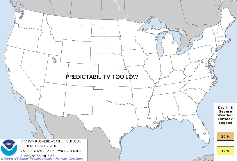
PREDICTABILITY TOO LOW is used to indicate severe storms may be possible based on some model scenarios. However, the location or occurrence of severe storms are in doubt due to: 1) large differences in the deterministic model solutions, 2) large spread in the ensemble guidance, and/or 3) minimal run-to-run continuity.
POTENTIAL TOO LOW means the threat for a regional area of organized severe storms appears unlikely (i.e., less than 15%) for the forecast day.
Forecast Discussion
ZCZC SPCSWOD48 ALL
ACUS48 KWNS 120937
SPC AC 120937
Day 4-8 Convective Outlook
NWS Storm Prediction Center Norman OK
0337 AM CST Thu Dec 12 2019
Valid 151200Z - 201200Z
...DISCUSSION...
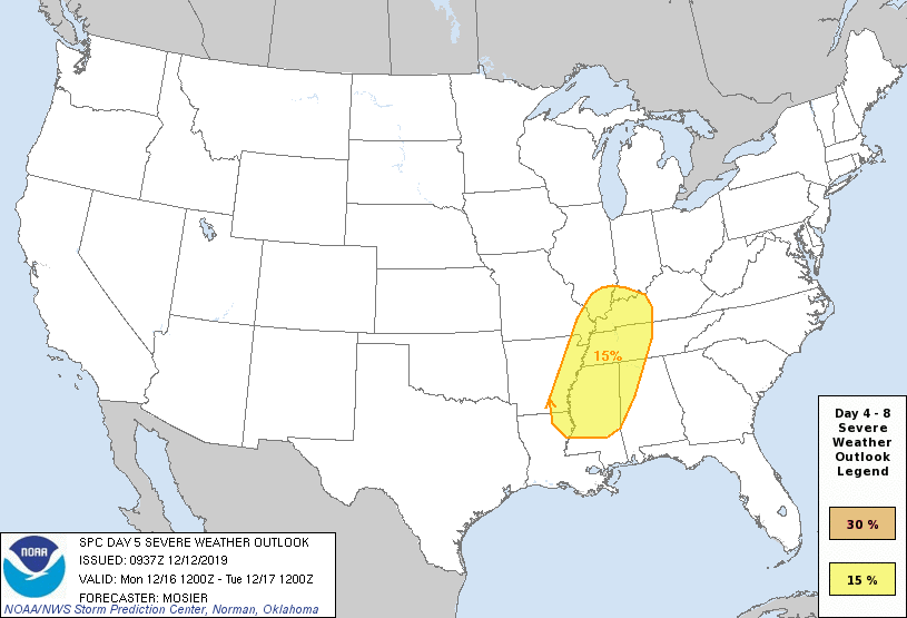
Medium-range guidance remains in relatively good agreement that a
shortwave trough will move from the Great Basin into the
southern/central Plains on D4/Sunday, continuing through the mid MS
Valley and into the Upper Great Lakes on D5/Monday. Guidance differs
on the location of the surface low associated with this shortwave
trough, with current forecasts of its position at 12Z D5/Monday
ranging from the KS/OK/MO border intersection to central TX. Even
with these differences, consensus is good for a moist and moderately
unstable environment from the Lower MS Valley through the TN Valley
on D5/Monday ahead of the approaching shortwave. Strong vertical
shear will extend across this region, supporting long hodographs and
supercell wind profiles. Consequently, there is a threat for severe
thunderstorms D5/Monday afternoon and evening from the Mid-South
into the Lower OH Valley as the shortwave trough and associated cold
front move through. Forecast confidence is high enough to introduce
severe probabilities. Refinements to this area are likely in
subsequent forecast as mesoscale details become more apparent.
Showers and thunderstorms are likely along the front as it continues
eastward through the remainder of the Southeast and Mid-Atlantic on
D6/Tuesday. However, favorable low-level moisture and instability
will become increasingly displaced south of the better large-scale
forcing for ascent, suggesting a more limited severe risk.
Dry and stable conditions are currently expected across the CONUS on
D7/Wednesday and D8/Thursday.
..Mosier.. 12/12/2019
CLICK TO GET WUUS48 PTSD48 PRODUCT


 @NWSSPC