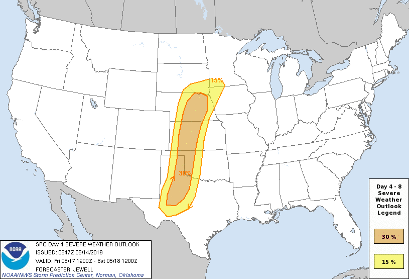
Day 4-8 Severe Weather Outlook Issued on May 14, 2019
Updated: Tue May 14 08:49:03 UTC 2019
Day 4 Risk
Area (sq. mi.)
Area Pop.
Some Larger Population Centers in Risk Area
30 %
107,604
1,147,772
Midland, TX...Grand Island, NE...Kearney, NE...Dodge City, KS...Big Spring, TX...
15 %
117,446
3,953,810
Omaha, NE...Lincoln, NE...Lubbock, TX...Amarillo, TX...Sioux Falls, SD...
Day 5 Risk
Area (sq. mi.)
Area Pop.
Some Larger Population Centers in Risk Area
15 %
258,234
22,501,491
Dallas, TX...Austin, TX...Fort Worth, TX...Oklahoma City, OK...Kansas City, MO...
Day 6 Risk
Area (sq. mi.)
Area Pop.
Some Larger Population Centers in Risk Area
15 %
102,452
8,737,163
Memphis, TN...St. Louis, MO...Little Rock, AR...Springfield, IL...Columbia, MO...
Day 7 Risk
Area (sq. mi.)
Area Pop.
Some Larger Population Centers in Risk Area
15 %
138,962
4,586,475
Oklahoma City, OK...Wichita, KS...Lubbock, TX...Amarillo, TX...Topeka, KS...
Day 8 Risk
Area (sq. mi.)
Area Pop.
Some Larger Population Centers in Risk Area
15 %
161,769
10,806,132
Oklahoma City, OK...Kansas City, MO...Omaha, NE...Tulsa, OK...Wichita, KS...
D4
Fri, May 17, 2019 - Sat, May 18, 2019
D7
Mon, May 20, 2019 - Tue, May 21, 2019
D5
Sat, May 18, 2019 - Sun, May 19, 2019
D8
Tue, May 21, 2019 - Wed, May 22, 2019
D6
Sun, May 19, 2019 - Mon, May 20, 2019
(All days are valid from 12 UTC - 12 UTC the following day)
Note: A severe weather area depicted in the Day 4-8 period indicates 15%, 30% or higher probability for severe thunderstorms within 25 miles of any point.
PREDICTABILITY TOO LOW is used to indicate severe storms may be possible based on some model scenarios. However, the location or occurrence of severe storms are in doubt due to: 1) large differences in the deterministic model solutions, 2) large spread in the ensemble guidance, and/or 3) minimal run-to-run continuity.
POTENTIAL TOO LOW means the threat for a regional area of organized severe storms appears unlikely (i.e., less than 15%) for the forecast day.
Forecast Discussion
   ZCZC SPCSWOD48 ALL
   ACUS48 KWNS 140847
   SPC AC 140847

   Day 4-8 Convective Outlook
   NWS Storm Prediction Center Norman OK
   0347 AM CDT Tue May 14 2019

   Valid 171200Z - 221200Z

   ...DISCUSSION...
   An active stretch for severe weather will occur during the entire
   D4-8 period, mainly over the central and southern Plains.

   ...Friday/D4...
   Increasing southwesterly winds aloft will spread eastward across the
   High Plains Friday as a large upper trough progresses east across
   the Rockies, with low pressure centered over the CO/NE/KS border
   region. A broad area of at least mid 60s F dewpoints will envelope
   much of the central and southern Plains, as well as much of the
   MS/TN/OH Valleys. Cooling temperatures aloft combined with heating
   along a dryline will result in 2000-2500 J/kg MUCAPE, on average,
   near the dryline, from central NE into west TX Friday afternoon.
   Strong heating west of the dryline will result in a narrow, but
   expansive north-south zone of supercell potential, with very large
   hail and tornadoes possible.

   ...Saturday/D5 into Sunday/D6...
   The leading wave is expected to eject in a negative tilt fashion
   over TX/OK/KS, with backing winds and rapid cooling aloft. While
   areas of ongoing storms may exist over northwest TX and OK Saturday
   morning, there will be a marked increase in storm coverage during
   the day, with a severe threat as far north as NE and IA. Widespread
   moisture (although likely weaker instability) will be sufficient for
   severe storms capable of damaging winds and a few tornadoes.
   Upgraded probabilities are possible in later outlooks as
   predictability increases.

   This upper wave will continue to progress northeastward toward the
   middle MS Valley on Sunday, with strong cooling aloft and impressive
   shear profiles. The slower ECMWF solution is preferred, suggesting a
   severe threat across parts of MO, IL and perhaps AR where it will be
   most unstable, although southern areas will see rising heights
   behind the wave. Details are difficult to assess at this point but
   damaging winds appear likely, along with a tornado or two.

   ...Monday/D7 into Tuesday/D8...
   An extensive mid/upper jet streak within a broad area of cyclonic
   flow aloft will nose eastward across the southwestern states and
   into the southern Plains on Monday/D7. Some model differences do
   exist regarding how amplified the trough will be, however, there
   will clearly be a substantial risk of severe weather over much of
   the central and southern Plains, as very strong wind shear develops
   with ample low-level moisture nearby and spreading north. Again,
   supercells producing very large hail and tornadoes are possible.
   Upgraded probabilities are possible in later outlooks as
   predictability increases.

   Models suggest that a large portion of the upper trough energy will
   eject across the Plains on Tuesday/D8, with both the ECMWF and GFS
   deterministic models showing a 100kt 500 mb jet streak, anywhere
   from the OK/TX Panhandles into MO. Regardless of timing, a large
   area of strong wind shear with the upper trough, with substantial
   moisture in place, will lead to severe weather. It is too early for
   details but all modes of severe appear possible once again. Upgraded
   probabilities are possible in later outlooks as predictability
   increases.

   Strong southwest flow aloft is forecast to remain over the Plains
   even beyond D8, suggesting a continued threat of severe.

   ..Jewell.. 05/14/2019

   CLICK TO GET WUUS48 PTSD48 PRODUCT


 @NWSSPC