| Tornado Reports (CSV) (Raw Tornado CSV)(?) |
|---|
Time | | Location | County | State | Lat | Lon | Comments |
| 1930 | | 3 NW Bokchito | Bryan | OK | 3405 | 9618 | Chaser reported tornado that lasted several minutes. Location estimated. (OUN) |
| 2335 | | 5 SSW Fort Sumner State | De Baca | NM | 3434 | 10424 | Photos from two chasers on social media indicate a tornado on the ground approximately 11 miles south of Fort Sumner. (ABQ) |
| 2342 | | 7 N Bitter Lake Wildlif | Chaves | NM | 3355 | 10440 | Tornado photographed 3 miles north of location. (ABQ) |
| 2348 | | 12 NNW Bitter Lake Wild | Chaves | NM | 3363 | 10447 | (ABQ) |
| 0006 | | 10 NNE Bitter Lake Wild | Chaves | NM | 3360 | 10433 | Social media video shows tornado on the ground near Acme NM. (ABQ) |
| Hail Reports (CSV) (Raw Hail CSV)(?) |
|---|
Time | Size | Location | County | State | Lat | Lon | Comments |
| 1211 | 175 | 3 SW Lawton | Comanche | OK | 3458 | 9845 | (OUN) |
| 1225 | 100 | 3 W Lawton | Comanche | OK | 3460 | 9845 | (OUN) |
| 1230 | 175 | 3 WNW Lawton | Comanche | OK | 3462 | 9844 | (OUN) |
| 2210 | 100 | 3 E Mauldin | Greenville | SC | 3478 | 8224 | Hail up to 2 inches deep ... some up to quarter sized. (GSP) |
| 2235 | 100 | Haworth | McCurtain | OK | 3384 | 9465 | (SHV) |
| 2238 | 175 | 1 SSW Pecos | Reeves | TX | 3139 | 10350 | Golf ball size hail reported per broadcast media source. Time estimated by radar and report. (MAF) |
| 2247 | 200 | 1 N Pecos | Reeves | TX | 3142 | 10350 | Multiple reports of Golf ball to Hen Egg size hail in Pecos. Time verified by reports and radar. (MAF) |
| 2251 | 100 | 2 S Yeso | De Baca | NM | 3440 | 10461 | (ABQ) |
| 2258 | 150 | 7 ENE Yeso | De Baca | NM | 3447 | 10448 | (ABQ) |
| 2315 | 200 | 9 SE Variadero | San Miguel | NM | 3530 | 10433 | (ABQ) |
| 2336 | 100 | 12 W Wink | Loving | TX | 3178 | 10336 | Quarter size hail reported on State Hwy 302 per Spotter Network. (MAF) |
| 2338 | 175 | 1 SSW Pecos | Reeves | TX | 3139 | 10350 | Corrects previous hail report from 1 SSW Pecos. Golf ball size hail reported per broadcast media source. Time estimated by radar and report. (MAF) |
| 2341 | 100 | 5 ESE Bonneau | Berkeley | SC | 3327 | 7987 | Received a report of quarter size hail ... some stones approaching ping pong ball size. Time estimated using radar data. (CHS) |
| 2347 | 200 | 1 N Pecos | Reeves | TX | 3142 | 10350 | Corrects previous hail report from 1 N Pecos. Multiple reports of Golf ball to Hen Egg size hail in Pecos. Time verified by reports and radar. (MAF) |
| 2350 | 250 | FM 1776 2 1/2 S US 285 | Pecos | TX | 3095 | 10307 | An Emergency Manager in Pecos County reported golf ball and tennis ball sized hail. (MAF) |
| 2350 | 100 | Ashdown | Little River | AR | 3367 | 9413 | Quarter-sized hail reported near the sheriffs office. (SHV) |
| 0005 | 250 | 8 NNE Bitter Lake Wildl | Chaves | NM | 3358 | 10437 | (ABQ) |
| 0021 | 100 | Jal | Lea | NM | 3211 | 10319 | A trained spotter reported quarter sized hail in Jal ... NM at 00:21Z. (MAF) |
| 0022 | 250 | I-10 254 mm | Pecos | TX | 3090 | 10295 | Emergency manager reported tennis ball size hail on I-10 at mm 254 west of Fort Stockton. (MAF) |
| 0032 | 125 | 6 N Jal | Lea | NM | 3220 | 10319 | Trained spotter reported half dollar sized hail 6 miles north of Jal ... NM at 00:32Z. (MAF) |
| 0033 | 150 | 8 SE Hugo | Lincoln | CO | 3906 | 10336 | Report via X. Time estimated based on radar. (BOU) |
| 0041 | 175 | Fort Stockton | Pecos | TX | 3089 | 10289 | Pecos County EM reported golf ball sized hail in the city of Fort Stockton ... TX. (MAF) |
| 0048 | 175 | 1 SSW Fort Stockton US | Pecos | TX | 3088 | 10289 | Pecos County EM reported golf ball sized hail 1 mile south of Fort Stockton on US 385. (MAF) |
| 0048 | 150 | 6 N Boyero | Lincoln | CO | 3901 | 10330 | Report from mPING: Ping Pong Ball (1.50 in.). (BOU) |
| 0055 | 200 | 1 N Pyote | Ward | TX | 3155 | 10313 | Report from mPING: Hen Egg (2.00 in.). (MAF) |
| 0105 | 250 | Fort Stockton | Pecos | TX | 3089 | 10289 | KWES reported tennis ball sized hail in the city of Fort Stockton ... TX. (MAF) |
| 0106 | 275 | 1 W Fort Stockton | Pecos | TX | 3089 | 10291 | Baseball sized hail reported on the west side of the city of Fort Stockton ... TX at approximately 01:06Z. (MAF) |
| 0115 | 500 | 5 SE Fort Stockton | Pecos | TX | 3084 | 10284 | Storm chaser Jeff Piotrowski reported 5 inch hail SE of Fort Stockton ... TX. (MAF) |
| 0135 | 100 | 5 E Puerto De Luna | Guadalupe | NM | 3482 | 10454 | (ABQ) |
| 0146 | 125 | Downtown Tatum | Lea | NM | 3326 | 10332 | A storm chaser reported half dollar sized hail in downtown Tatum ... NM at 02:46Z. (MAF) |
| 0150 | 200 | 2 E Tatum | Lea | NM | 3326 | 10328 | A storm chaser reported 2 inch hail approximately 2.4 miles to the east of Tatum ... NM and blew out windshield of vehicle. (MAF) |
| 0155 | 150 | 3 E Tatum | Lea | NM | 3326 | 10327 | Storm chasers reported ping pong sized hail 3 miles east of Tatum ... NM. (MAF) |
| 0540 | 100 | 1 WSW El Dorado | Union | AR | 3322 | 9267 | (SHV) |
| Wind Reports (CSV) (Raw Wind CSV)(?) |
|---|
Time | Speed | Location | County | State | Lat | Lon | Comments |
| 2235 | UNK | Haworth | McCurtain | OK | 3385 | 9465 | Tree downed onto power lines on East Arkansas Avenue in Haworth. (SHV) |
| 2238 | 60 | Haworth | McCurtain | OK | 3385 | 9465 | (SHV) |
| 2251 | UNK | 4 S Sherman | Fairfield | CT | 4152 | 7351 | Eversource reports 75 customers without power. (OKX) |
| 2312 | UNK | 2 SSE Shady Point | Le Flore | OK | 3510 | 9465 | Powerlines down. (TSA) |
| 2339 | UNK | 1 S Hackett | Sebastian | AR | 3517 | 9441 | Tree partially blocking the road. (TSA) |
| 2359 | 65 | Jenny Lind | Sebastian | AR | 3525 | 9432 | (TSA) |
| 0125 | UNK | 1 WSW Magnolia | Duplin | NC | 3489 | 7807 | Trees down blocking both lanes of Highway 903 ... near Beasleys Road. (MHX) |
| 0155 | 59 | 3 WSW Tatum Mesonet | Lea | NM | 3324 | 10335 | The Tatum Mesonet recorded a wind speed of 59 mph. (MAF) |
| 0540 | UNK | El Dorado | Union | AR | 3322 | 9266 | Several Trees down in El Dorado. (SHV) |


 @NWSSPC
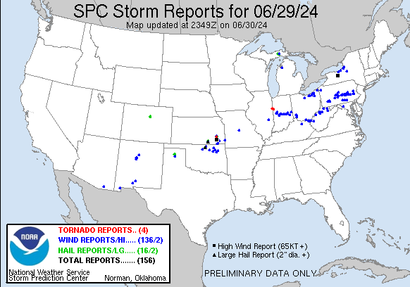