| Tornado Reports (CSV) (Raw Tornado CSV)(?) |
|---|
Time | | Location | County | State | Lat | Lon | Comments |
| 1911 | | 1 SW Walker | Livingston | LA | 3047 | 9088 | [Landspout] Video of what appears to be a landspout/gustnado on Lakeview Dr in Walker. Mainly displaced trash can and flung light debris. Did not break branches of sma (LIX) |
| 2100 | | 1 E Ponderosa Park | Elbert | CO | 3940 | 10461 | (BOU) |
| 2147 | | 4 ENE Council Bluffs | Pottawattamie | IA | 4127 | 9580 | Brief tornado crossed I-80. (OAX) |
| 2235 | | 2 NE Fairbury | Jefferson | NE | 4017 | 9715 | (OAX) |
| 2310 | | 15 S Silverton | Floyd | TX | 3425 | 10130 | Multiple reports confirmed via video feed. (LUB) |
| 2321 | | 6 W Camp Houston | Woods | OK | 3680 | 9922 | (OUN) |
| 2344 | | 7 WSW Camp Houston | Woods | OK | 3679 | 9923 | (OUN) |
| 0015 | | 9 SW Flomot | Floyd | TX | 3413 | 10108 | Multiple public and spotter reports. (LUB) |
| 0035 | | 10 S Ralls | Crosby | TX | 3353 | 10138 | Short lived tornado. Crosby SO. (LUB) |
| 0102 | | 4 W Roaring Springs | Motley | TX | 3390 | 10093 | Brief tornado observed. (LUB) |
| 0115 | | 10 W White River Lake | Crosby | TX | 3347 | 10127 | Potentially as wide as 1/4 mile at greatest intensity. (LUB) |
| 0150 | | 11 SSW White River Lake | Garza | TX | 3333 | 10114 | Brief touchdown occurred. (LUB) |
| 0205 | | 11 NNW Codman | Roberts | TX | 3580 | 10080 | Several reports of tornado on the ground east of HWY70. (AMA) |
| 0222 | | 12 NE Post | Garza | TX | 3331 | 10123 | (LUB) |
| 0230 | | 4 NW Miami | Roberts | TX | 3574 | 10068 | Broadcast livestream indicated some fencing damage and power lines down at Highway 283 north of Miami at Quarter Horse Road. (AMA) |
| 0233 | | 3 NW Miami | Roberts | TX | 3573 | 10068 | Powerlines were blown down on a car and report of a person trapped in the car. This was estimated to be located along Highway 283 northwest of Miami approx 2 miles nort (AMA) |
| 0251 | | 13 ENE Post | Garza | TX | 3326 | 10117 | (LUB) |
| Hail Reports (CSV) (Raw Hail CSV)(?) |
|---|
Time | Size | Location | County | State | Lat | Lon | Comments |
| 2005 | 100 | 4 WSW Fickling Mill | Taylor | GA | 3264 | 8424 | Quarter-sized hail was reported in north Taylor county between Butler and Fickling Mill. (FFC) |
| 2108 | 100 | 2 NNE Ralston | Douglas | NE | 4123 | 9602 | (OAX) |
| 2110 | 125 | 2 N Ralston | Douglas | NE | 4123 | 9604 | (OAX) |
| 2112 | 200 | Reynolds | Taylor | GA | 3256 | 8409 | Emergency manager provided a picture of 2 inch hail from Reynolds ... GA. (FFC) |
| 2113 | 100 | 2 N Ralston | Douglas | NE | 4123 | 9604 | (OAX) |
| 2114 | 100 | 2 NE Ralston | Douglas | NE | 4123 | 9603 | Report from mPING: Quarter (1.00 in.). (OAX) |
| 2115 | 175 | Reynolds | Taylor | GA | 3255 | 8409 | Broadcast media provided a photo of golf ball sized hail in Reynolds ... Georgia. The location was estimated by radar. (FFC) |
| 2117 | 150 | Reynolds | Taylor | GA | 3256 | 8410 | Picture on social media of ping pong ball sized hail at the intersection of N Crawford St and Horry St. (FFC) |
| 2117 | 100 | 3 SE Omaha | Douglas | NE | 4123 | 9598 | Report from mPING: Quarter (1.00 in.). (OAX) |
| 2118 | 100 | 2 NE Ralston | Douglas | NE | 4122 | 9600 | (OAX) |
| 2123 | 100 | Ralston | Douglas | NE | 4120 | 9603 | Report from mPING: Quarter (1.00 in.). (OAX) |
| 2123 | 100 | 2 E Omaha | Douglas | NE | 4126 | 9597 | (OAX) |
| 2125 | 100 | Ralston | Douglas | NE | 4120 | 9603 | Report from mPING: Quarter (1.00 in.). (OAX) |
| 2129 | 175 | 2 SE Omaha | Douglas | NE | 4124 | 9599 | (OAX) |
| 2130 | 300 | 3 ENE Ralston | Douglas | NE | 4121 | 9599 | Pictures on Social Media. (OAX) |
| 2132 | 100 | 2 SSE Meade | Meade | KS | 3726 | 10032 | Time estimated from radar. (DDC) |
| 2138 | 100 | 2 WNW Hudson | Weld | CO | 4008 | 10468 | (BOU) |
| 2150 | 100 | 2 NNW Council Bluffs | Pottawattamie | IA | 4127 | 9587 | (OAX) |
| 2153 | 125 | 2 N Council Bluffs | Pottawattamie | IA | 4127 | 9587 | Report from mPING: Half Dollar (1.25 in.). (OAX) |
| 2156 | 100 | 12 S Sitka | Clark | KS | 3700 | 9965 | (DDC) |
| 2200 | 125 | 4 NE Council Bluffs | Pottawattamie | IA | 4127 | 9580 | Report from mPING: Half Dollar (1.25 in.). (OAX) |
| 2200 | 175 | 4 NE Council Bluffs | Pottawattamie | IA | 4128 | 9581 | (OAX) |
| 2203 | 175 | 4 NE Council Bluffs | Pottawattamie | IA | 4128 | 9581 | (OAX) |
| 2205 | 150 | 12 S Sitka | Clark | KS | 3700 | 9965 | (DDC) |
| 2205 | 125 | 2 N Council Bluffs | Pottawattamie | IA | 4127 | 9585 | Pictures on social media. (OAX) |
| 2207 | 125 | 10 N Buffalo | Harper | OK | 3698 | 9963 | Relayed by KOCO tv. (OUN) |
| 2211 | 175 | 10 N Buffalo | Harper | OK | 3697 | 9963 | koco tv. (OUN) |
| 2225 | 100 | 1 W Evans | Weld | CO | 4038 | 10473 | (BOU) |
| 2225 | 100 | 4 W Underwood | Pottawattamie | IA | 4139 | 9576 | (OAX) |
| 2230 | 100 | 12 S Sitka | Clark | KS | 3700 | 9965 | (DDC) |
| 2238 | 100 | Evans | Weld | CO | 4038 | 10470 | Report from mPING: Quarter (1.00 in.). (BOU) |
| 2250 | 125 | 7 S Silverton | Briscoe | TX | 3437 | 10131 | mPing. (LUB) |
| 2250 | 175 | 9 NW Englewood | Clark | KS | 3714 | 10008 | (DDC) |
| 2250 | 175 | 3 NE Council Bluffs | Pottawattamie | IA | 4128 | 9582 | Pictures on social media. (OAX) |
| 2257 | 150 | 7 N South Plains | Briscoe | TX | 3433 | 10131 | Report from mPING: Ping Pong Ball (1.50 in.). (LUB) |
| 2313 | 100 | Idalou | Lubbock | TX | 3367 | 10169 | Report from mPING: Quarter (1.00 in.). (LUB) |
| 2317 | 250 | 8 ENE Selman | Harper | OK | 3685 | 9936 | FROM KOCO. (OUN) |
| 2333 | 250 | 3 NE South Plains | Floyd | TX | 3426 | 10127 | NSSL Report. (LUB) |
| 2345 | 125 | 6 ENE Pringle | Hutchinson | TX | 3599 | 10137 | (AMA) |
| 2346 | 100 | 1 SSE Borger | Hutchinson | TX | 3565 | 10139 | (AMA) |
| 2352 | 200 | 6 NE Pringle | Hutchinson | TX | 3600 | 10137 | (AMA) |
| 2356 | 100 | 6 N Punkin Center | Lincoln | CO | 3894 | 10370 | Report from mPING: Quarter (1.00 in.). (BOU) |
| 0000 | 450 | 10 ESE South Plains | Floyd | TX | 3415 | 10115 | Via X ... tape measured. (LUB) |
| 0000 | 100 | Spearman | Hansford | TX | 3620 | 10119 | (AMA) |
| 0001 | 225 | 6 NE Pringle | Hutchinson | TX | 3600 | 10136 | Report from mPING: Hen Egg+ (2.25 in.). (AMA) |
| 0002 | 400 | 10 SE South Plains | Floyd | TX | 3415 | 10115 | Report from mPING: Grapefruit (4.00 in.). (LUB) |
| 0002 | 400 | 7 ESE South Plains | Floyd | TX | 3419 | 10119 | (LUB) |
| 0004 | 125 | Gruver | Hansford | TX | 3626 | 10141 | (AMA) |
| 0010 | 100 | 9 SE Floydada | Floyd | TX | 3388 | 10125 | Delayed report. (LUB) |
| 0014 | 150 | 9 WNW Waka | Hansford | TX | 3633 | 10119 | (AMA) |
| 0015 | 400 | 7 W Flomot | Floyd | TX | 3419 | 10110 | Report from mPING: Grapefruit (4.00 in.). (LUB) |
| 0020 | 250 | 11 E Pringle | Hutchinson | TX | 3602 | 10128 | Report from mPING: Tennis Ball (2.50 in.). (AMA) |
| 0021 | 300 | 9 SSW Spearman | Hansford | TX | 3608 | 10127 | (AMA) |
| 0022 | 100 | 4 S Union | Carroll | GA | 3379 | 8499 | Public caller reported hail ranging from the size of a pea to the size of a quarter near the intersection of Chrissy Dr and Kenny Ln ... with hail falling for 15 minutes (FFC) |
| 0027 | 520 | 9 SSW Flomot | Floyd | TX | 3411 | 10106 | Via X ... measured with calipers. Exact location estimated with radar. (LUB) |
| 0032 | 100 | 7 SSW Jetmore | Hodgeman | KS | 3799 | 9992 | (DDC) |
| 0035 | 175 | 1 SSE Spearman | Hansford | TX | 3619 | 10119 | (AMA) |
| 0049 | 150 | 9 NE Karval | Lincoln | CO | 3885 | 10348 | Report from mPING: Ping Pong Ball (1.50 in.). (BOU) |
| 0053 | 250 | 7 N Kinsley | Edwards | KS | 3802 | 9941 | Report from social media with video. (DDC) |
| 0054 | 200 | 9 WNW Spearville | Hodgeman | KS | 3791 | 9990 | (DDC) |
| 0055 | 100 | 6 WSW Beattie | Marshall | KS | 3984 | 9652 | (TOP) |
| 0059 | 100 | 9 S Rozel | Edwards | KS | 3806 | 9942 | (DDC) |
| 0101 | 500 | Matador | Motley | TX | 3401 | 10082 | (LUB) |
| 0102 | 250 | 8 S Ralls | Crosby | TX | 3356 | 10138 | Multiple reports. (LUB) |
| 0106 | 100 | Greenleaf | Washington | KS | 3973 | 9698 | Report from mPING: Quarter (1.00 in.). (TOP) |
| 0110 | 150 | 9 WNW Spearville | Hodgeman | KS | 3791 | 9990 | (DDC) |
| 0115 | 175 | 7 NNE Karval | Lincoln | CO | 3882 | 10348 | (BOU) |
| 0118 | 100 | 5 NE Kinsley | Edwards | KS | 3797 | 9935 | (DDC) |
| 0122 | 100 | 1 WSW Bryans Corner | Beaver | OK | 3662 | 10083 | (AMA) |
| 0128 | 100 | 4 NNW Stonewall | Caddo | LA | 3232 | 9383 | Dime/quarter size hail in Keithville. (SHV) |
| 0150 | 200 | 7 S Spearman | Hansford | TX | 3610 | 10118 | (AMA) |
| 0150 | 125 | 4 W Kit Carson | Cheyenne | CO | 3876 | 10287 | Spotter located ~4 miles west of Kit Carson reported quarter to half dollar sized hail at ~7:50 pm MDT. Spotter sent pictures of the hail ... as well. Strong winds were (GLD) |
| 0209 | 175 | 7 S Kit Carson | Cheyenne | CO | 3866 | 10279 | delayed report of golf ball size hail. Windows were knocked out of buildings as well at location. (GLD) |
| 0218 | 100 | Mooreland | Woodward | OK | 3644 | 9921 | (OUN) |
| 0220 | 250 | 8 NE Eads | Kiowa | CO | 3857 | 10267 | Images shared from emergency management of large hail. Largest hail estimated to around 2.5 inches when compared to baseball in images. Damage reported to multiple vehi (PUB) |
| 0255 | 150 | 4 S Chivington | Kiowa | CO | 3838 | 10254 | (PUB) |
| 0326 | 100 | 1 S Fairview | Major | OK | 3626 | 9848 | KOCO tv. (OUN) |
| 0355 | 150 | 1 WSW Briscoe | Wheeler | TX | 3558 | 10031 | Second hand report from Fire Chief. (AMA) |
| 0408 | 100 | 1 E Lake Quivira | Johnson | KS | 3904 | 9475 | A few quarter size stones spotted. (EAX) |
| 0445 | 100 | 2 NE Piper | Wyandotte | KS | 3916 | 9483 | Report from mPING: Quarter (1.00 in.). (EAX) |
| Wind Reports (CSV) (Raw Wind CSV)(?) |
|---|
Time | Speed | Location | County | State | Lat | Lon | Comments |
| 1852 | UNK | 6 SW Gholson | McLennan | TX | 3165 | 9731 | Photo of large tree downed and damaged powerlines in China Spring. (FWD) |
| 1909 | 67 | 4 NW Waco | McLennan | TX | 3161 | 9723 | 67 MPH gust measured at Waco Regional Airport. (FWD) |
| 1910 | UNK | 2 WNW Beverly Hills | McLennan | TX | 3153 | 9718 | Significant wind damage to a fast food restaurant on North Valley Mills Drive. Time estimated by RADAR. (FWD) |
| 1938 | UNK | 1 S Riesel | McLennan | TX | 3146 | 9693 | Delayed Report. Roof damage to home and several broken tree limbs in the same area. Time estimated by radar. (FWD) |
| 2050 | 62 | 2 NNW Ponderosa Park | Elbert | CO | 3942 | 10466 | (BOU) |
| 2054 | 65 | 1 ENE Ponderosa Park | Elbert | CO | 3940 | 10462 | (BOU) |
| 2055 | 76 | 1 E Ponderosa Park | Elbert | CO | 3940 | 10462 | (BOU) |
| 2057 | 76 | 1 E Ponderosa Park | Elbert | CO | 3940 | 10462 | (BOU) |
| 2130 | UNK | 19 ENE Centerville | Leon | TX | 3134 | 9567 | Trees and power lines blown down along Hwy 7 between FM 542 and the Trinity River ... and a hay barn was blown down on the north side of Hwy 7 near Trinity River. (FWD) |
| 2210 | UNK | 1 ESE Gallatin | Cherokee | TX | 3189 | 9514 | Multiple trees and power lines were downed across Cherokee County. (SHV) |
| 2348 | UNK | 5 SSW Nacogdoches | Nacogdoches | TX | 3156 | 9469 | A tree was downed across a power line on County Road 6102 on the southwest side of Nacogdoches. (SHV) |
| 0025 | 61 | 3 SSW Freedom | Woodward | OK | 3673 | 9913 | (OUN) |
| 0030 | 63 | 3 SSW Freedom | Woodward | OK | 3673 | 9913 | Corrects previous tstm wnd gst report from 3 SSW Freedom. (OUN) |
| 0130 | 62 | 2 ENE Goodwell | Texas | OK | 3660 | 10160 | A heat burst occurred around 2030CDT from decaying thunderstorms. (AMA) |
| 0140 | UNK | 8 NE Stonewall | Caddo | LA | 3235 | 9372 | A large limb was snapped off of a tree in the St. Charles neighborhood. (SHV) |
| 0145 | UNK | 2 SSW Shreveport | Caddo | LA | 3245 | 9381 | *** 1 INJ *** Tree fell into house; partial house collapse. One injury. (SHV) |
| 0145 | UNK | 2 NE Shreveport | Caddo | LA | 3249 | 9378 | Tree fell into power lines and house. (SHV) |
| 0429 | 65 | Kremlin | Garfield | OK | 3655 | 9783 | (OUN) |


 @NWSSPC
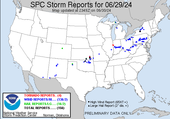