| Tornado Reports (CSV) (Raw Tornado CSV)(?) |
|---|
Time | | Location | County | State | Lat | Lon | Comments |
| 2132 | | 10 NNW Briggs | Burnet | TX | 3103 | 9800 | *** 1 INJ *** Report of 5 homes damaged along CR 223. 1 driver was injured on CR 223. NWS will be surveying damage on Friday. (EWX) |
| Hail Reports (CSV) (Raw Hail CSV)(?) |
|---|
Time | Size | Location | County | State | Lat | Lon | Comments |
| 1914 | 100 | University Heights | Cuyahoga | OH | 4150 | 8154 | (CLE) |
| 1915 | 100 | 2 SSE Bedford Heights | Cuyahoga | OH | 4139 | 8149 | (CLE) |
| 1919 | 100 | 1 NW Solon | Cuyahoga | OH | 4140 | 8146 | Report from mPING: Quarter (1.00 in.). (CLE) |
| 1919 | 125 | Lyndhurst | Cuyahoga | OH | 4152 | 8149 | Public report on social media. (CLE) |
| 1923 | 100 | 1 SW Mayfield | Cuyahoga | OH | 4154 | 8145 | (CLE) |
| 1928 | 125 | Highland Heights | Cuyahoga | OH | 4155 | 8148 | (CLE) |
| 1929 | 100 | Callao | Northumberland | VA | 3797 | 7656 | 50 mph wind gust recorded on personal weather station. (AKQ) |
| 1952 | 100 | 1 NNE Lonaconing | Allegany | MD | 3957 | 7898 | Quarter sized hail observed near the intersection of Alexander St and E Main St. (LWX) |
| 2021 | 100 | 2 S Copperas Cove | Coryell | TX | 3110 | 9790 | Report from mPING. (FWD) |
| 2022 | 100 | 2 N Copperas Cove | Coryell | TX | 3115 | 9791 | Report from mPING. (FWD) |
| 2025 | 100 | Ridgeley | Allegany | MD | 3965 | 7877 | Quarter sized hail observed on I-68 West of Cumberland. (LWX) |
| 2026 | 125 | 1 SW Copperas Cove | Coryell | TX | 3110 | 9791 | Report from mPING. (FWD) |
| 2037 | 100 | 11 N Copperas Cove | Coryell | TX | 3128 | 9789 | Report from mPING. (FWD) |
| 2038 | 125 | 2 N Copperas Cove | Coryell | TX | 3115 | 9791 | Report from mPING. (FWD) |
| 2044 | 125 | Fort Cavazos | Coryell | TX | 3115 | 9777 | 1.25 inch hail reported by USAF at Fort Cavazos. (FWD) |
| 2048 | 100 | 1 SW Pleasant Valley | Allegany | MD | 3970 | 7865 | Quarter sized hail estimated near Rocky Gap State Park. (LWX) |
| 2050 | 150 | Copperas Cove | Coryell | TX | 3112 | 9790 | (FWD) |
| 2057 | 200 | 2 N Copperas Cove | Coryell | TX | 3115 | 9791 | Report from mPING. (FWD) |
| 2104 | 450 | 1 WSW Copperas Cove | Coryell | TX | 3111 | 9792 | Report of a few baseball to grapefruit size hail stones. (FWD) |
| 2118 | 125 | 2 N Copperas Cove | Coryell | TX | 3115 | 9791 | Report from mPING. (FWD) |
| 2120 | 175 | 1 SE Copperas Cove | Coryell | TX | 3111 | 9790 | Report from mPING. (FWD) |
| 2125 | 100 | North Branch | Allegany | MD | 3959 | 7873 | (LWX) |
| 2130 | 150 | 1 E Patterson Creek | Allegany | MD | 3957 | 7871 | Ping pong ball sized hail observed 6 miles SE of Cumberland ... MD. (LWX) |
| 2134 | 125 | 1 W Copperas Cove | Coryell | TX | 3112 | 9791 | Report from mPING. (FWD) |
| 2135 | 175 | 1 SE North Branch | Allegany | MD | 3958 | 7872 | (LWX) |
| 2145 | 275 | 1 E Buchanan Lake Villa | Llano | TX | 3086 | 9843 | Delayed report. (EWX) |
| 2145 | 100 | 1 SE Copperas Cove | Coryell | TX | 3111 | 9790 | Report from mPING. (FWD) |
| 2207 | 100 | 1 NNE Calhoun City | Calhoun | MS | 3387 | 8931 | (MEG) |
| 2230 | 150 | 8 NNE Broaddus | San Augustine | TX | 3140 | 9421 | Quarter to ping pong ball size hail fell in the Norwood community. (SHV) |
| 2230 | 150 | 8 NNE Broaddus | San Augustine | TX | 3141 | 9422 | Quarter to ping pong ball size hail fell in the Norwood community. (SHV) |
| 2232 | 175 | 5 SSE Mason | Mason | TX | 3069 | 9920 | Spotter reported a lot of 1 inch hail with a few golf ball sized hailstones mixed in. (SJT) |
| 2238 | 100 | Iredell | Bosque | TX | 3198 | 9787 | (FWD) |
| 2247 | 100 | Monroeville | Monroe | AL | 3153 | 8732 | Numerous photos and videos of 1+ inch hail in Monroeville. Photos and videos via social media. (MOB) |
| 2247 | 175 | 3 NNE Murphysboro | Jackson | IL | 3781 | 8932 | Ping pong ball to golfball size hail just north of Murphysboro at Ava Rd and Highway 13/127. (PAH) |
| 2248 | 100 | 4 E Flintstone | Allegany | MD | 3969 | 7850 | (LWX) |
| 2255 | 175 | 1 N Inks Lake State Par | Burnet | TX | 3076 | 9837 | Observed near SH29 and Park Road 4. (EWX) |
| 2255 | 175 | Peterman | Monroe | AL | 3158 | 8726 | Photos of 1.5 to almost 2.0 inch hail in the Peterman community. Photo was taken with the hail measured against a ruler. Photos via social media. (MOB) |
| 2300 | 125 | Junction | Kimble | TX | 3049 | 9977 | Numerous quarter to half dollar sized hailstones. (SJT) |
| 2300 | 250 | 3 NNE Buchanan Dam | Burnet | TX | 3078 | 9839 | (EWX) |
| 2300 | 150 | 4 SSE Holcomb | Grenada | MS | 3371 | 8996 | Ping Pong ball size hail in Holcomb MS. (JAN) |
| 2300 | 100 | Freemont | Carter | MO | 3695 | 9116 | Nickel up to quarter size hail in Fremont. (PAH) |
| 2301 | 100 | 3 SSE Felps | East Feliciana | LA | 3093 | 9089 | Sherrifs Office reported quarter sized hail along Hwy 961 ... 3 miles north of Hwy 10 in east Feliciana Parish. (LIX) |
| 2305 | 100 | Junction | Kimble | TX | 3049 | 9977 | Sheriffs office reported lots of dime sized hail with some quarters mixed in. (SJT) |
| 2306 | 275 | 26 SSW Ozona | Crockett | TX | 3036 | 10134 | (SJT) |
| 2315 | 100 | Van Buren | Carter | MO | 3700 | 9101 | (PAH) |
| 2327 | 100 | Carterville | Williamson | IL | 3776 | 8908 | Dime to quarter size hail in Carterville. (PAH) |
| 2336 | 150 | 8 SSW San Augustine | San Augustine | TX | 3142 | 9416 | Both in the Macune and Norwood Community. (SHV) |
| 2344 | 100 | 2 W Marion | Williamson | IL | 3773 | 8897 | (PAH) |
| 2345 | 175 | 2 S Stonewall | De Soto | LA | 3223 | 9382 | Off of Long Rd ... south of Red Bluff Rd. (SHV) |
| 2346 | 175 | 1 NE Stonewall | De Soto | LA | 3227 | 9380 | Ping pong ball to golf ball size hail fell in the Plantation Hills subdivision. (SHV) |
| 2346 | 175 | 1 NE Stonewall | De Soto | LA | 3228 | 9380 | Ping pong ball to golfball size hail fell in the Plantation Hills subdivision. (SHV) |
| 2349 | 100 | 4 W Andice | Williamson | TX | 3079 | 9791 | Near intersection of CR208 and CR236. (EWX) |
| 2349 | 100 | Marion | Williamson | IL | 3773 | 8894 | (PAH) |
| 0004 | 100 | 8 NE Stonewall | Caddo | LA | 3235 | 9372 | Subdivision off Norris Ferry Road. (SHV) |
| 0008 | 225 | 2 NE Inks Lake State Pa | Burnet | TX | 3076 | 9835 | Report from mPING. (EWX) |
| 0010 | 250 | 2 NNE Inks Lake State P | Burnet | TX | 3077 | 9835 | Reported on Hwy 29 east of Buchanan Dam. (EWX) |
| 0012 | 100 | 8 NE Stonewall | Caddo | LA | 3235 | 9373 | Report from mPING of 1 inch hail. (SHV) |
| 0015 | 125 | Broaddus | San Augustine | TX | 3130 | 9427 | A long duration of quarter to half dollar size hail fell along Highway 147 between CR 348 and Highway 1277 near Broaddus High School. The hail completely covered the gr (SHV) |
| 0015 | 125 | Broaddus | San Augustine | TX | 3131 | 9427 | A long duration of quarter to half dollar size hail fell along Highway 147 between CR 348 and Highway 1277 near Broaddus High School. The hail completely covered the gr (SHV) |
| 0019 | 275 | 5 NE Buchanan Dam | Burnet | TX | 3081 | 9837 | Reported at 690 and CR 114. (EWX) |
| 0025 | 175 | Bossier City | Bossier | LA | 3252 | 9366 | A picture of golfball size hail that fell near Sun City Elementary in Bossier City was posted to social media. (SHV) |
| 0027 | 125 | 6 S Barksdale Air Force | Caddo | LA | 3242 | 9370 | Report of Half Dollar size hail in the Southgate Estates area. (SHV) |
| 0041 | 175 | 1 SW Haughton | Bossier | LA | 3252 | 9352 | Report via mPING. Started off with ping pongs and turned into Golf Balls. (SHV) |
| 0049 | 100 | San Saba | San Saba | TX | 3119 | 9872 | (SJT) |
| 0109 | 125 | 4 N Burnet | Burnet | TX | 3082 | 9824 | Report from mPING. (EWX) |
| 0109 | 100 | 7 N Burnet | Burnet | TX | 3086 | 9824 | Report from mPING. (EWX) |
| 0226 | 125 | 2 S Hereford | Deaf Smith | TX | 3480 | 10240 | (AMA) |
| 0233 | 150 | 6 SE Lampasas | Burnet | TX | 3101 | 9812 | Report from mPING. (EWX) |
| 0238 | 175 | 6 SE Lampasas | Burnet | TX | 3101 | 9812 | Report from mPING. (EWX) |
| 0528 | 125 | Mangum | Greer | OK | 3488 | 9950 | (OUN) |
| 0543 | 100 | 1 W Tipton | Tillman | OK | 3451 | 9916 | (OUN) |
| 0608 | 100 | 3 SW Lawton | Comanche | OK | 3458 | 9845 | Report from mPING: Quarter (1.00 in.). (OUN) |
| 0616 | 100 | Chattanooga | Comanche | OK | 3442 | 9866 | (OUN) |
| 0621 | 125 | 5 NE Davidson | Tillman | OK | 3430 | 9904 | Report from mPING: Half Dollar (1.25 in.). (OUN) |
| 0621 | 150 | 2 S Chattanooga | Tillman | OK | 3440 | 9866 | (OUN) |
| 0621 | 100 | 3 W Lawton | Comanche | OK | 3460 | 9845 | Report from mPING: Quarter (1.00 in.). (OUN) |
| 0628 | 100 | 3 W Lawton | Comanche | OK | 3460 | 9845 | Report from mPING: Quarter (1.00 in.). (OUN) |
| 0640 | 125 | 4 S Frederick | Tillman | OK | 3434 | 9903 | (OUN) |
| 0850 | 100 | 1 W Guy | Faulkner | AR | 3532 | 9235 | Report from mPING: Quarter (1.00 in.). (LZK) |
| 1038 | 100 | Panama | Le Flore | OK | 3517 | 9467 | (TSA) |
| Wind Reports (CSV) (Raw Wind CSV)(?) |
|---|
Time | Speed | Location | County | State | Lat | Lon | Comments |
| 1528 | UNK | 4 E Versailles | Ripley | IN | 3905 | 8518 | Fallen tree on roadway. Time estimated from RADAR. (ILN) |
| 1555 | UNK | 2 SW Bradford | Darke | OH | 4011 | 8445 | Tree down on Smith Road. Photo verified. Time estimated from RADAR. (ILN) |
| 1820 | UNK | Flat Rock | Seneca | OH | 4123 | 8286 | A few reports of wind damage around Flat Rock including a snapped tree ... downed limbs ... a downed power-line ... and a trampoline that was well-anchored being picked up (CLE) |
| 1820 | UNK | Castalia | Erie | OH | 4140 | 8281 | Tree and wires down. (CLE) |
| 1832 | 58 | 3 N Sandusky | LEZ144 | OH | 4149 | 8270 | Mesonet station XSDB 2 NNE Sandusky. (CLE) |
| 1856 | UNK | 3 NNW Marshall | Highland | OH | 3919 | 8348 | One tree down. Time estimated from radar. (ILN) |
| 1914 | 58 | 2 SSW Green | Summit | OH | 4092 | 8145 | ASOS station KCAK Akron-Canton Regional Arpt. (CLE) |
| 1921 | UNK | Elyria | Lorain | OH | 4137 | 8211 | Healthy 8 inch diameter tree snapped ... landing on top of a detached garage. (CLE) |
| 1929 | UNK | North Ridgeville | Lorain | OH | 4139 | 8202 | Tree limbs and a wire downed in North Ridgeville. (CLE) |
| 1929 | UNK | Waite Hill | Lake | OH | 4161 | 8138 | Tree downed on Hobart Rd. (CLE) |
| 1933 | UNK | 2 SW North Olmsted | Cuyahoga | OH | 4140 | 8194 | Large tree limb downed. (CLE) |
| 1936 | UNK | 1 SSE Mentor | Lake | OH | 4167 | 8132 | Public report of trees snapped. (CLE) |
| 1938 | UNK | Bay Village | Cuyahoga | OH | 4149 | 8192 | Tree downed on Lake Road. (CLE) |
| 1938 | UNK | Mentor | Lake | OH | 4169 | 8134 | Tree downed onto house ... causing structural damage. No injuries reported. (CLE) |
| 1942 | UNK | 3 ENE Mentor | Lake | OH | 4170 | 8129 | Tree downed along West Jackson Street in Painesville Twp. (CLE) |
| 1943 | UNK | 2 ESE Fairview Park | Cuyahoga | OH | 4144 | 8182 | Large tree down on house. (CLE) |
| 1950 | UNK | 3 NW Centerville | Crawford | PA | 4177 | 7978 | Crawford County PA EMA reports trees and wires down in Athens and Sparta Townships. Time estimated via radar. (CLE) |
| 1958 | UNK | 1 SE Independence | Cuyahoga | OH | 4136 | 8163 | Tree snapped and fell on a power line ... knocking out power in the area. (CLE) |
| 2000 | UNK | Jamestown | Chautauqua | NY | 4210 | 7924 | Relayed report (from Jamestown BPU social media post) of multiple trees/limbs and power lines down in the Jamestown area. Time estimated from radar. (BUF) |
| 2000 | UNK | 1 E Lakewood | Chautauqua | NY | 4210 | 7930 | Tree down on house in Lakewood NY near Squires Ave. (BUF) |
| 2005 | UNK | 2 SSW Bratenahl | Cuyahoga | OH | 4154 | 8162 | Wall collapsed onto sidewalk. (CLE) |
| 2018 | UNK | 1 E Blissfield | Coshocton | OH | 4040 | 8195 | Trees down on County Road 25 (PBZ) |
| 2019 | UNK | 1 S La Vale | Allegany | MD | 3965 | 7882 | Tree down near the intersection of Orchard St and Valley View Dr (LWX) |
| 2022 | UNK | 1 SE La Vale | Allegany | MD | 3965 | 7880 | Tree down onto power lines near the intersection of Nemacolin Ave and Cherrywood Ave. (LWX) |
| 2024 | UNK | 2 WSW Rural Retreat | Wythe | VA | 3689 | 8129 | One tree down on Sage Road. (RNK) |
| 2026 | UNK | Cumberland | Allegany | MD | 3965 | 7876 | Several trees down in the Cumberland area. (LWX) |
| 2028 | UNK | 3 SW Jefferson | Ashtabula | OH | 4171 | 8082 | Ashtabula County EMA reported trees down in the areas of Roaming Shores ... Morgan Township ... and Jefferson. Time estimated via radar. (CLE) |
| 2107 | UNK | Fairview | Erie | PA | 4203 | 8026 | Large Tree Branch Down. (CLE) |
| 2112 | UNK | Louisville | Stark | OH | 4084 | 8126 | Trees and wires downed in the Louisville area. (CLE) |
| 2121 | UNK | 1 SW Patterson Creek | Mineral | WV | 3956 | 7874 | Multiple trees down in the area of Patterson creek. (LWX) |
| 2122 | UNK | 7 SW Copperas Cove | Lampasas | TX | 3104 | 9798 | Report from social media of shingle damage to a home south of Kempner. Home weather station measured 82 mph wind gust. (FWD) |
| 2125 | UNK | 1 SSW Reedsville | Preston | WV | 3950 | 7981 | Tree down on Route 92. (PBZ) |
| 2128 | UNK | Harborcreek | Erie | PA | 4217 | 7995 | Medium sized tree down at Buffalo Rd and Iroquois Ave. Time estimated via radar. (CLE) |
| 2136 | UNK | 5 E Flintstone | Allegany | MD | 3971 | 7848 | Multiple trees down along Old Cumberland Rd. (LWX) |
| 2138 | UNK | 2 S Westover | Monongalia | WV | 3961 | 7998 | Tree down on River Road. (PBZ) |
| 2200 | UNK | Girard | Trumbull | OH | 4115 | 8070 | Report of two trees down in Girard. (CLE) |
| 2202 | UNK | 2 N Scottsboro | Jackson | AL | 3467 | 8605 | Tree down that may have led to power outages in Scottsboro. (HUN) |
| 2202 | UNK | 6 NW Scottsboro | Jackson | AL | 3470 | 8613 | Corrects previous tstm wnd dmg report from 6 NW Scottsboro. Tree and power lines down. Time estimated from radar. (HUN) |
| 2207 | UNK | 3 NNE Scottsboro | Jackson | AL | 3468 | 8602 | Tree down in roadway on CR 21. Time estimated from radar. (HUN) |
| 2220 | UNK | 5 ESE Stevenson | Jackson | AL | 3484 | 8575 | Tree down in roadway near AL HWY 117 and CR 14. (HUN) |
| 2222 | UNK | 6 NW Scottsboro | Jackson | AL | 3470 | 8613 | Tree and power lines down. (HUN) |
| 2226 | 62 | 1 E Clayton | Union | NM | 3645 | 10315 | Corrects previous tstm wnd gst report from 1 E Clayton. ASOS station KCAO Clayton Muni Airpark. (ABQ) |
| 2230 | UNK | 4 NNW Casselman | Somerset | PA | 3994 | 7925 | Wires down near the intersection of Scullton Road and Hilltop Drive just west of New Lexington. (CTP) |
| 2230 | UNK | 6 S Seven Springs | Somerset | PA | 3994 | 7930 | Tree and possibly wires down across Scullton Road near the intersection with Whipkey Dam Road ... blocking most of roadway. (CTP) |
| 2231 | UNK | 5 NW Ider | Jackson | AL | 3474 | 8573 | Tree down along HWY 71. (HUN) |
| 2232 | UNK | 6 NNE Ohiopyle | Fayette | PA | 3995 | 7945 | Trees down in the Mill Run area. (PBZ) |
| 2233 | UNK | 7 SW Champion | Fayette | PA | 4000 | 7945 | Trees down in the Normalville area. (PBZ) |
| 2234 | 62 | 1 E Clayton | Union | NM | 3645 | 10315 | ASOS station KCAO Clayton Muni Airpark. (ABQ) |
| 2235 | UNK | 2 SSE Champion | Fayette | PA | 4005 | 7936 | Tree down on Nebo Road. (PBZ) |
| 2253 | UNK | 1 NW Boswell | Somerset | PA | 4017 | 7904 | Tree and possibly wires down near intersection of Clay Hill Road and Four Seasons Road near Boswell. (CTP) |
| 2259 | 60 | 3 NNW Buffalo | Johnson | WY | 4438 | 10672 | ASOS station KBYG Buffalo Airport; Convective rain shower with no lightning present. (RIW) |
| 2300 | 65 | 1 NNW Buffalo | Johnson | WY | 4436 | 10671 | Mesonet station GW1458 BUFFALO; Convective shower ... but no lightning present. (RIW) |
| 2305 | UNK | 1 SSE Belmont | Cambria | PA | 4026 | 7888 | Trees and wires down in the 600 block of Eisenhower Blvd just south of Geistown. (CTP) |
| 2307 | UNK | 1 NNE Elim | Cambria | PA | 4031 | 7893 | Trees and wires down near the intersection of Diamond Blvd and Susan Drive in Southmont. (CTP) |
| 2307 | UNK | WSW Johnstown | Cambria | PA | 4032 | 7893 | Numerous reports of trees and wires down on the west and south side of Johnstown from Brownstown to Westmont to Southmont to Ferndale. (CTP) |
| 2320 | UNK | 2 NNW Wilmore | Cambria | PA | 4042 | 7874 | Wires down on PSP cruiser. (CTP) |
| 2334 | UNK | 3 SSW Chest Springs | Cambria | PA | 4055 | 7863 | A one story wood storage building was destroyed in the 1100 block of Columbia Street in Allegheny Township north of Loretto. (CTP) |
| 2335 | UNK | 2 W Flushing | Genesee | MI | 4306 | 8387 | Video showing snapped power line poles near Flushing. (DTX) |
| 2339 | UNK | 2 ENE Chest Springs | Cambria | PA | 4059 | 7857 | A roof was blown off a barn in the 1100 block of Schoolhouse Road east of Chest Springs. (CTP) |
| 2350 | UNK | 1 S Coalport | Clearfield | PA | 4074 | 7853 | Trees and wires down along the 3700 block of Glendale Blvd just south of Coalport. (CTP) |
| 0026 | UNK | 7 NNW Richards | Grimes | TX | 3064 | 9586 | Large tree the over roadway on Highway 30 at FM2620 in Shiro. (HGX) |
| 0515 | 59 | 2 NE Elk City | Beckham | OK | 3543 | 9940 | (OUN) |
| 0519 | 60 | 3 S Elk City | Beckham | OK | 3537 | 9942 | (OUN) |
| 0520 | 62 | 6 SSE Elk City | Beckham | OK | 3533 | 9939 | (OUN) |
| 0536 | 66 | 2 W Burns Flat | Washita | OK | 3535 | 9920 | (OUN) |
| 0655 | UNK | 3 NE Cookietown | Cotton | OK | 3430 | 9842 | Semi truck blown over. Time and location estimated by radar. (OUN) |
| 0705 | 61 | 4 NW Walters | Cotton | OK | 3440 | 9835 | (OUN) |
| 0900 | 58 | Burneyville | Love | OK | 3390 | 9730 | (OUN) |
| 0900 | UNK | 4 SW Overbrook | Love | OK | 3402 | 9720 | 1 tree branches blown down. Time estimated. (OUN) |
| 0925 | 74 | 4 NNW Lebanon | Marshall | OK | 3403 | 9694 | Corrects previous non-tstm wnd gst report from 4 NNW Lebanon. (OUN) |
| 0945 | UNK | 3 SW Milburn | Johnston | OK | 3421 | 9658 | Trees blown down. Time estimated. (OUN) |


 @NWSSPC
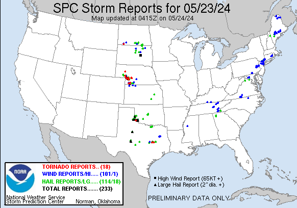