| Tornado Reports (CSV) (Raw Tornado CSV)(?) |
|---|
Time | | Location | County | State | Lat | Lon | Comments |
| 1940 | | 3 WSW Brewster | Nobles | MN | 4368 | 9553 | Brief touchdown in an open field. No known damage. (FSD) |
| 2255 | | 6 W Kenyon | Rice | MN | 4426 | 9311 | Brief tornado visible in video and photos of structure damage to a farm. Lofted debris blown downstream about a mile. Time estimated from radar. (MPX) |
| 2337 | | Belvue | Pottawatomie | KS | 3922 | 9617 | Storm chaser videos showed what was originally a gustnado feature becoming connected to the updraft on the leading edge of the gust front as it moved through Belvue. Th (TOP) |
| 0033 | | 16 SSW Eau Claire | Eau Claire | WI | 4460 | 9160 | A confirmed tornado touched down northeast of Mondovi in Buffalo County then lifted after briefly crossing into southern Eau Claire County. Some structure and tree dama (MPX) |
| 0048 | | 10 SW Fall Creek | Eau Claire | WI | 4465 | 9139 | Corrects previous tornado report from 10 SW Fall Creek. A confirmed tornado briefly touched down just south of Cleghorn and west of Foster. Multiple pine trees were upr (MPX) |
| 0055 | | 10 SW Fall Creek | Eau Claire | WI | 4465 | 9139 | Structure damage and photos confirm a tornado in southern Eau Claire County. The path may stretch to east of Augusta. Time estimated from radar. (MPX) |
| 0057 | | 8 S Fall Creek | Eau Claire | WI | 4465 | 9128 | A brief tornado was confirmed near Hale Corner with minor tree and structure damage noted. Time estimated from radar. (MPX) |
| 0107 | | 3 SE Augusta | Eau Claire | WI | 4464 | 9108 | A confirmed tornado touched down south of Augusta and traveled northeast across US-12 before dissipating north of Fairchild. Both structure and tree damage were noted. (MPX) |
| 0300 | | 3 E Birnamwood | Shawano | WI | 4493 | 8912 | Corrects time for previous tornado report from 3 E Birnamwood. (GRB) |
| 0302 | | 3 E Birnamwood | Shawano | WI | 4493 | 8912 | . (GRB) |
| 0304 | | Mattoon | Shawano | WI | 4500 | 8903 | (GRB) |
| Hail Reports (CSV) (Raw Hail CSV)(?) |
|---|
Time | Size | Location | County | State | Lat | Lon | Comments |
| 1340 | 150 | Britt | Hancock | IA | 4310 | 9380 | (DMX) |
| 1815 | 100 | Beaver Creek | Rock | MN | 4361 | 9636 | (FSD) |
| 1826 | 200 | 2 E Beaver Creek | Rock | MN | 4362 | 9632 | Report from mPING: Hen Egg (2.00 in.). (FSD) |
| 1827 | 275 | 2 ENE Beaver Creek | Rock | MN | 4362 | 9632 | Non-uniform hail measured at 2.8 inches at its widest. (FSD) |
| 1945 | 175 | 6 SW Kinbrae | Nobles | MN | 4378 | 9557 | Report via social media. (FSD) |
| 1954 | 100 | 5 ENE Dundee | Cottonwood | MN | 4386 | 9538 | Lots of quarter size hail. (FSD) |
| 2006 | 100 | 3 SE Brewster | Jackson | MN | 4366 | 9543 | (FSD) |
| 2007 | 100 | 3 SW Sidney | Clark | WI | 4452 | 9068 | Public report relayed by broadcast media. (ARX) |
| 2007 | 125 | 2 SE Sidney | Clark | WI | 4453 | 9063 | (ARX) |
| 2016 | 100 | Windom | Cottonwood | MN | 4387 | 9512 | (FSD) |
| 2018 | 100 | 4 ENE Round Lake | Jackson | MN | 4356 | 9539 | ground covered in nickel to quarter size hail. (FSD) |
| 2036 | 100 | 2 W Merrill | Lincoln | WI | 4519 | 8971 | Report from mPING: Quarter (1.00 in.). (GRB) |
| 2057 | 175 | 10 SW Midkiff | Upton | TX | 3153 | 10195 | Ping Pong to Golf Ball size hail reported by public via social media. Time was estimated by radar. (MAF) |
| 2106 | 100 | 3 SE Luxemburg | Stearns | MN | 4542 | 9420 | Time estimated via radar. Photo measurement provided. (MPX) |
| 2116 | 150 | 3 NW Clearwater | Stearns | MN | 4545 | 9409 | Delayed report of ping pong sized hail north of Clearwater via Facebook. Time estimated from radar. (MPX) |
| 2129 | 100 | Fostoria | Clay | IA | 4324 | 9516 | (FSD) |
| 2130 | 100 | 1 NNE St. Peter | Nicollet | MN | 4434 | 9396 | Picture via X. (MPX) |
| 2134 | 150 | 5 SW Santiago | Sherburne | MN | 4549 | 9390 | Time estimated via radar. Photo measurement provided. (MPX) |
| 2138 | 150 | Santiago | Sherburne | MN | 4554 | 9382 | Time estimated via radar. (MPX) |
| 2140 | 150 | 3 W Santiago | Sherburne | MN | 4553 | 9387 | Delayed report via X with picture of 1.5 inch hail. (MPX) |
| 2156 | 150 | Solomon | Dickinson | KS | 3892 | 9736 | (TOP) |
| 2215 | 150 | 4 WSW Wakefield | Clay | KS | 3919 | 9708 | (TOP) |
| 2218 | 200 | 6 E New Cambria | Saline | KS | 3888 | 9745 | Corrects previous hail report from 3 E New Cambria. (ICT) |
| 2220 | 150 | Dickens | Clay | IA | 4313 | 9502 | Mostly dime to quarter sized ... but some as large as ping pong balls. Time estimated via radar. (FSD) |
| 2221 | 150 | 5 ENE Saint Lawrence | Glasscock | TX | 3173 | 10146 | Ping Pong Ball size hail reported by NWS Employee about 5 miles ENE of Saint Lawrence. (MAF) |
| 2230 | 250 | 7 SE Clay Center | Riley | KS | 3937 | 9692 | Corrects previous hail report from 3 W Leonardville. Photos shared to NWS Employee. Radar estimated time. (TOP) |
| 2231 | 100 | 6 N Ruthven | Palo Alto | IA | 4322 | 9490 | Mostly dime to nickel but a few up to quarter. (DMX) |
| 2235 | 125 | Marty | Charles Mix | SD | 4299 | 9843 | Quarters to slightly larger hail reported via social media. Time estimated by radar. (FSD) |
| 2236 | 250 | 3 W Leonardville | Riley | KS | 3937 | 9692 | Photos shared to NWS Employee. Radar estimated time. (TOP) |
| 2237 | 100 | 1 N Abilene | Dickinson | KS | 3893 | 9722 | (TOP) |
| 2239 | 150 | Abilene | Dickinson | KS | 3892 | 9722 | (TOP) |
| 2244 | 175 | 5 ENE Graettinger | Emmet | IA | 4327 | 9466 | Dime to golf ball sized hail. (DMX) |
| 2245 | 275 | Abilene | Dickinson | KS | 3892 | 9721 | Via social media photo. Delayed report. (TOP) |
| 2248 | 150 | Chicagon Lake | Iron | MI | 4606 | 8852 | Image from local news. Time estimated via radar. (MQT) |
| 2253 | 100 | 5 SSE Milford | Geary | KS | 3910 | 9688 | (TOP) |
| 2254 | 125 | 6 NE Frost | Faribault | MN | 4365 | 9386 | (MPX) |
| 2255 | 150 | Gaastra | Iron | MI | 4606 | 8861 | Estimated 1.5in hail stone. Report via social media comment. (MQT) |
| 2258 | 100 | Blue Rapids | Marshall | KS | 3968 | 9666 | (TOP) |
| 2300 | 100 | Chambers | Holt | NE | 4221 | 9875 | Report and photo via social media. (LBF) |
| 2301 | 100 | 3 S Chillicothe | Hardeman | TX | 3422 | 9951 | (OUN) |
| 2304 | 125 | 1 S Le Mars | Plymouth | IA | 4277 | 9617 | (FSD) |
| 2304 | 100 | 1 SE Le Mars | Plymouth | IA | 4278 | 9616 | Nickel to quarter size hail from 604 to 610 pm. A few stones slightly larger than quarter size. (FSD) |
| 2307 | 175 | 3 SSE Chillicothe | Hardeman | TX | 3422 | 9950 | (OUN) |
| 2308 | 175 | Chillicothe | Hardeman | TX | 3426 | 9951 | (OUN) |
| 2310 | 175 | 2 NNE Hope | Steele | MN | 4398 | 9326 | Measurement provided via phone. (MPX) |
| 2310 | 125 | Iron River | Iron | MI | 4610 | 8864 | Report via social media. (MQT) |
| 2311 | 150 | 2 NE Ogden | Riley | KS | 3913 | 9668 | (TOP) |
| 2311 | 100 | 2 WNW Oyens | Plymouth | IA | 4283 | 9610 | (FSD) |
| 2312 | 100 | 5 NNW Junction City | Geary | KS | 3910 | 9687 | (TOP) |
| 2313 | 100 | Owatonna | Steele | MN | 4409 | 9322 | Measurement provided via phone. (MPX) |
| 2315 | 100 | 5 ESE Milford | Riley | KS | 3916 | 9683 | Photos on social media. (TOP) |
| 2315 | 175 | 2 NNE Hope | Steele | MN | 4398 | 9326 | Picture via X showing golf ball sized hail. (MPX) |
| 2325 | 100 | Saint George | Pottawatomie | KS | 3919 | 9642 | Via social media photo. Delayed report. (TOP) |
| 2325 | 100 | Swea City | Kossuth | IA | 4339 | 9431 | Report from mPING: Quarter (1.00 in.). (DMX) |
| 2327 | 100 | 1 W Sterling City | Sterling | TX | 3184 | 10100 | (SJT) |
| 2328 | 175 | 5 N Beresford | Lincoln | SD | 4315 | 9678 | Quarter to golf ball sized hail reported via social media. (FSD) |
| 2334 | 100 | 3 N Center | Knox | NE | 4265 | 9788 | (OAX) |
| 2335 | 100 | 2 N Altus | Jackson | OK | 3467 | 9932 | Report from mPING: Quarter (1.00 in.). (OUN) |
| 2342 | 100 | Mazeppa | Wabasha | MN | 4427 | 9255 | (ARX) |
| 2343 | 100 | 3 W Inwood | Lyon | IA | 4329 | 9651 | Report via social media. (FSD) |
| 2343 | 100 | 3 SE Worthing | Lincoln | SD | 4330 | 9673 | Hail up to quarter size along U.S. Highway 18 and Minnesota Ave. (FSD) |
| 2345 | 100 | 3 E Martha | Jackson | OK | 3471 | 9934 | Report from mPING: Quarter (1.00 in.). (OUN) |
| 2345 | 125 | 4 SSW Alden | Freeborn | MN | 4362 | 9360 | (MPX) |
| 2348 | 100 | 1 S Blair | Jackson | OK | 3476 | 9934 | Report from mPING: Quarter (1.00 in.). (OUN) |
| 2348 | 100 | Fairview | Lincoln | SD | 4322 | 9649 | Report via social media. (FSD) |
| 2348 | 100 | 2 W Buffalo Center | Kossuth | IA | 4339 | 9399 | (DMX) |
| 2351 | 200 | 2 S Blair | Jackson | OK | 3475 | 9933 | (OUN) |
| 2351 | 200 | Blair | Jackson | OK | 3478 | 9934 | Report from mPING: Hen Egg (2.00 in.). (OUN) |
| 2352 | 100 | Kasson | Dodge | MN | 4403 | 9275 | Relayed via Emergency Manager. (ARX) |
| 2354 | 125 | 4 SE Rake | Winnebago | IA | 4344 | 9385 | Delayed report. Relayed through media partner. (DMX) |
| 2355 | 100 | Saint George | Pottawatomie | KS | 3919 | 9642 | Photos on social media. Mainly nickel sized ... with a few quarter sized mixing in. (TOP) |
| 2356 | 100 | 3 NNW Blair | Greer | OK | 3483 | 9935 | (OUN) |
| 2356 | 100 | 2 E Sunset | Marathon | WI | 4496 | 8944 | (GRB) |
| 0000 | 100 | Doon | Lyon | IA | 4328 | 9623 | Report via social media. (FSD) |
| 0000 | 150 | 2 N Albert Lea | Freeborn | MN | 4368 | 9336 | (DELAYED REPORT) Photo on Facebook with hailstone next to measuring tape near Albert Lea HS. (MPX) |
| 0002 | 150 | 6 NE Crofton | Cedar | NE | 4279 | 9741 | Public caller reported lots of hail falling down with the largest being ping pong ball sized. (OAX) |
| 0008 | 200 | 4 W George | Lyon | IA | 4334 | 9608 | Hen egg sized hail reported via broadcast media. (FSD) |
| 0009 | 175 | 2 SW George | Lyon | IA | 4332 | 9603 | Ping pong to golf ball sized hail reported via social media. (FSD) |
| 0010 | 130 | 5 N Bloomfield | Knox | NE | 4267 | 9765 | delayed report. (OAX) |
| 0017 | 100 | 3 ESE Gayville | Clay | SD | 4287 | 9712 | (FSD) |
| 0025 | 125 | Sibley | Osceola | IA | 4340 | 9574 | Quarter to half dollar sized hail reported via social media. (FSD) |
| 0030 | 100 | 5 N Louisville | Pottawatomie | KS | 3933 | 9630 | (TOP) |
| 0053 | 100 | Altus | Jackson | OK | 3464 | 9933 | (OUN) |
| 0059 | 100 | 1 NE Predmore | Olmsted | MN | 4396 | 9232 | Report from mPING: Quarter (1.00 in.). (ARX) |
| 0111 | 100 | 3 E Iatan | Platte | MO | 3948 | 9493 | time estimated via radar. (EAX) |
| 0113 | 100 | 2 N Cherokee | Cherokee | IA | 4277 | 9555 | (FSD) |
| 0129 | 125 | 1 SW Mangum | Greer | OK | 3487 | 9951 | Report from mPING: Half Dollar (1.25 in.). (OUN) |
| 0130 | 100 | 5 E Wesley | Hancock | IA | 4310 | 9390 | (DMX) |
| 0132 | 300 | 1 SW Mangum | Greer | OK | 3487 | 9951 | Report from mPING: Tea Cup (3.00 in.). (OUN) |
| 0133 | 300 | Mangum | Greer | OK | 3488 | 9950 | Photos on social media and NWSChat. (OUN) |
| 0140 | 150 | 6 NW Garner | Hancock | IA | 4316 | 9370 | (DMX) |
| 0145 | 100 | 2 NW Altus Air Force Ba | Jackson | OK | 3467 | 9932 | Report from mPING: Quarter (1.00 in.). (OUN) |
| 0209 | 100 | 4 SSE Humphreys | Jackson | OK | 3451 | 9922 | Corrects previous hail report from Public to Trained Spotter. (OUN) |
| 0210 | 100 | Garner | Hancock | IA | 4310 | 9360 | (DMX) |
| 0223 | 100 | 1 W Ventura | Cerro Gordo | IA | 4313 | 9347 | Report from mPING: Quarter (1.00 in.). (DMX) |
| 0242 | 100 | Osage | Mitchell | IA | 4328 | 9281 | Report from mPING: Quarter (1.00 in.). (ARX) |
| 0342 | 100 | 4 WNW Earlsboro | Pottawatomie | OK | 3529 | 9686 | Lots of hail below 1 inch with some quarter size hail. Location is S Creek and Benson Park Rd. (OUN) |
| 0407 | 100 | 3 E Chickasha | Grady | OK | 3505 | 9790 | Report from mPING: Quarter (1.00 in.). (OUN) |
| 0411 | 100 | 4 W Norman | Cleveland | OK | 3523 | 9751 | Report from mPING: Quarter (1.00 in.). (OUN) |
| 0413 | 150 | 2 E Tabler | Grady | OK | 3504 | 9779 | Report from mPING: Ping Pong Ball (1.50 in.). (OUN) |
| 0415 | 100 | 4 W Norman | Cleveland | OK | 3523 | 9751 | Report from mPING: Quarter (1.00 in.). (OUN) |
| 0426 | 100 | Blanchard | McClain | OK | 3515 | 9766 | (OUN) |
| 0426 | 100 | 1 N Blanchard | McClain | OK | 3516 | 9766 | Report from mPING: Quarter (1.00 in.). (OUN) |
| 0427 | 175 | 5 E Seminole | Gaines | TX | 3272 | 10257 | (MAF) |
| 0429 | 100 | 2 W Blanchard | Grady | OK | 3513 | 9769 | Report from mPING: Quarter (1.00 in.). (OUN) |
| 0430 | 175 | 1 E Blanchard | McClain | OK | 3515 | 9764 | Report from mPING: Golf Ball (1.75 in.). (OUN) |
| 0437 | 125 | 2 S Goldsby | McClain | OK | 3512 | 9747 | Report from mPING: Half Dollar (1.25 in.). (OUN) |
| 0438 | 100 | 2 S Norman | Cleveland | OK | 3519 | 9745 | Report from mPING: Quarter (1.00 in.). (OUN) |
| 0438 | 100 | 5 SE Newcastle | McClain | OK | 3519 | 9755 | Report from mPING: Quarter (1.00 in.). (OUN) |
| 0439 | 150 | Tecumseh | Pottawatomie | OK | 3526 | 9694 | Report from mPING: Ping Pong Ball (1.50 in.). (OUN) |
| 0441 | 100 | 3 NW Noble | Cleveland | OK | 3517 | 9742 | Report from mPING: Quarter (1.00 in.). (OUN) |
| 0445 | 200 | Noble | Cleveland | OK | 3514 | 9739 | Time estimated by radar. (OUN) |
| 0446 | 125 | 2 NE Noble | Cleveland | OK | 3516 | 9737 | Corrects time for previous hail report from 2 NE Noble. (OUN) |
| 0447 | 100 | 3 SE Norman | Cleveland | OK | 3518 | 9742 | Report from mPING: Quarter (1.00 in.). (OUN) |
| 0448 | 100 | 2 N Noble | Cleveland | OK | 3517 | 9740 | Report from mPING: Quarter (1.00 in.). (OUN) |
| 0654 | 100 | 1 N Bates City | Lafayette | MO | 3901 | 9407 | Report from mPING: Quarter (1.00 in.) time adjusted based on radar. (EAX) |
| 0925 | 100 | 1 NE Pampa | Gray | TX | 3556 | 10095 | (AMA) |
| 0929 | 150 | 1 NE Pampa | Gray | TX | 3556 | 10095 | (AMA) |
| 1100 | 125 | 3 WNW Chandler | Lincoln | OK | 3573 | 9692 | (OUN) |
| 1135 | 100 | Hominy | Osage | OK | 3641 | 9640 | Dime to occasional Quarter size hail. Winds estimated at 50 mph. (TSA) |
| 1135 | 125 | 3 E Bartlesville | Washington | OK | 3675 | 9593 | Report from mPING: Half Dollar (1.25 in.). (TSA) |
| 1140 | 175 | 2 NW Bartlesville | Osage | OK | 3677 | 9601 | (TSA) |
| 1147 | 125 | 6 W Skiatook | Osage | OK | 3637 | 9611 | Report from mPING: Half Dollar (1.25 in.). (TSA) |
| Wind Reports (CSV) (Raw Wind CSV)(?) |
|---|
Time | Speed | Location | County | State | Lat | Lon | Comments |
| 2033 | 60 | 5 NW Jackson | Jackson | MN | 4367 | 9505 | (FSD) |
| 2128 | 60 | 4 WNW Terril | Dickinson | IA | 4333 | 9505 | Estimated 50 to 60 mph wind gusts along with small branches down. Pea sized hail also reported. (FSD) |
| 2205 | 74 | 2 WNW Gruver | Emmet | IA | 4341 | 9475 | At Estherville Airport. (DMX) |
| 2234 | UNK | Minnesota Lake | Faribault | MN | 4385 | 9383 | Amateur Radio operator provided photo of large pine tree blown over. (MPX) |
| 2240 | UNK | 3 E Morristown | Rice | MN | 4423 | 9339 | Delayed report ... time estimated from radar. Roof blown off shed near 250th Street east of Morristown. (MPX) |
| 2250 | UNK | 6 W Kenyon | Rice | MN | 4426 | 9311 | Barn destroyed ... silos destroyed ... semi tipped over. Time estimated via radar. (MPX) |
| 2300 | UNK | Kenyon | Goodhue | MN | 4427 | 9298 | Photos provided of roof damage reported to large commercial warehouse in Kenyon. Time estimated via radar. (MPX) |
| 2328 | 60 | 2 ESE Saint George | Pottawatomie | KS | 3918 | 9639 | (TOP) |
| 2331 | 68 | 3 WNW Wamego | Pottawatomie | KS | 3922 | 9634 | Weather station measured 68 mph wind gust 3 northwest of Wamego at 631pm. (TOP) |
| 2346 | UNK | 3 N Saint Marys | Pottawatomie | KS | 3923 | 9606 | Outbuilding damaged. (TOP) |
| 2354 | 60 | 8 S Abilene | Dickinson | KS | 3880 | 9721 | (TOP) |
| 0000 | UNK | 1 ESE Mayetta | Jackson | KS | 3933 | 9570 | Building damage. Time estimated by radar. (TOP) |
| 0035 | 70 | 3 W Huron | Atchison | KS | 3964 | 9542 | (EAX) |
| 0035 | 64 | 3 NE Sibley | Osceola | IA | 4343 | 9571 | Mesonet station RSYI4 Sibley. (FSD) |
| 0041 | 61 | Lancaster | Atchison | KS | 3957 | 9530 | Reported via private weather sensor. Time confirmed from radar. (EAX) |
| 0115 | UNK | 5 WNW Agency | Buchanan | MO | 3968 | 9483 | Downed wires near Kyle Road. Time based on dispatch report and confirmed from radar. (EAX) |
| 0123 | 60 | 5 W Withee | Clark | WI | 4495 | 9069 | (ARX) |
| 0140 | UNK | Edgerton | Platte | MO | 3950 | 9463 | Downed wires near Standsford Avenue. Time estimated from radar. (EAX) |
| 0204 | UNK | 3 W Anita | Cass | IA | 4145 | 9482 | Branches down. Hail to the size of nickels. (DMX) |
| 0224 | 67 | 6 NE Halder | Marathon | WI | 4486 | 8979 | Delayed report. Reported by mobile trained weather spotter with measuring equipment northwest of Mosinee. Confirmed by Marathon County Emergency Manager. (GRB) |
| 0225 | UNK | 4 SE Rothschild | Marathon | WI | 4484 | 8955 | Tree caught fire and fell on power line. (GRB) |
| 0251 | UNK | Weldon | Decatur | IA | 4090 | 9373 | Demolished barn. Time estimate based on reported wind gust. (DMX) |
| 0253 | 62 | 2 S Ames | Story | IA | 4199 | 9362 | (DMX) |
| 0304 | UNK | 1 S Mattoon | Shawano | WI | 4499 | 8903 | Trees and power poles down. (GRB) |
| 0307 | 58 | 2 E Nevada | Story | IA | 4202 | 9340 | Personal weather station KIANEVAD36. (DMX) |
| 0307 | 59 | 2 NE Mccallsburg | Story | IA | 4218 | 9336 | Personal weather station. (DMX) |
| 0427 | UNK | Cedar Falls | Black Hawk | IA | 4252 | 9245 | Powerlines down and trees snapped. Shingles blown off a roof as well. (DMX) |
| 0430 | 61 | 2 SE Menominee | Marinette | WI | 4510 | 8759 | Buoy station MNMM4 Menominee. (GRB) |
| 0554 | 93 | 1 N O'Donnell | Lynn | TX | 3298 | 10183 | Measured by TTU mesonet. (LUB) |
| 0633 | 64 | 1 NE Post | Garza | TX | 3320 | 10137 | Measured by TTU mesonet. (LUB) |
| 0712 | 62 | 10 WSW Guthrie | King | TX | 3357 | 10048 | Measured by TTU mesonet. (LUB) |
| 0730 | 58 | Alma | Lafayette | MO | 3910 | 9355 | Mesonet station MOA29 Alma. (EAX) |
| 0742 | 58 | 2 SW Mount Leonard | Saline | MO | 3910 | 9342 | Personal Weather Station Gust. (EAX) |
| 0815 | 60 | 4 NNW Goree | Knox | TX | 3352 | 9955 | (OUN) |
| 0835 | 68 | 3 NW Goree | Knox | TX | 3350 | 9956 | (OUN) |
| 0845 | 60 | 3 NW Seymour | Baylor | TX | 3362 | 9930 | (OUN) |
| 0854 | 60 | 2 WNW Del Rio | Val Verde | TX | 2938 | 10093 | Corrects previous non-tstm wnd gst report from 2 WNW Del Rio. ASOS station KDRT Del Rio Intl Airport gust from a possible wake low event with thunderstorm nearby. (EWX) |
| 0900 | UNK | 2 NNW Del Rio | Val Verde | TX | 2938 | 10091 | Wind damage from possible wake low from thunderstorm complex near Del Rio high school along Memorial Drive and Avondale Street. Roof damage to several buildings at apar (EWX) |
| 0905 | UNK | Electra | Wichita | TX | 3404 | 9891 | Downed power poles. Also roof damage to several homes. Time is estimated by radar. (OUN) |
| 0910 | UNK | Haynesville | Wichita | TX | 3409 | 9891 | Tree and power pole damage. Also several metal sheds damaged in and around Punkin Center. Time estimated by radar. (OUN) |
| 0930 | 80 | 3 W Grandfield | Tillman | OK | 3423 | 9874 | Grandfield Mesonet. (OUN) |
| 0932 | UNK | Grandfield | Tillman | OK | 3423 | 9868 | Roof damage to home on south side of Grandfield. (OUN) |
| 0932 | UNK | 1 W Grandfield | Tillman | OK | 3423 | 9870 | Large metal car port damage on far west side of Grandfield. Time estimated by severe wind gust at Grandfield mesonet. (OUN) |
| 0935 | 64 | 3 W Grandfield | Tillman | OK | 3423 | 9874 | (OUN) |
| 0935 | UNK | 2S of Chattanooga Sky H | Tillman | OK | 3434 | 9868 | Horse trailer rolled along with extensive damage to outbuildings on property. Also significant tree damage. (OUN) |
| 0955 | 58 | 4 NW Walters | Cotton | OK | 3440 | 9836 | Walters Mesonet. (OUN) |
| 1000 | 59 | 4 NW Walters | Cotton | OK | 3440 | 9836 | Walters Mesonet. (OUN) |
| 1003 | 64 | 6 SE Lawton | Comanche | OK | 3455 | 9832 | (OUN) |
| 1025 | 77 | 4 WNW Rush Springs | Grady | OK | 3480 | 9802 | Rush Springs Mesonet. (OUN) |
| 1030 | 59 | 4 WNW Rush Springs | Grady | OK | 3480 | 9802 | (OUN) |


 @NWSSPC
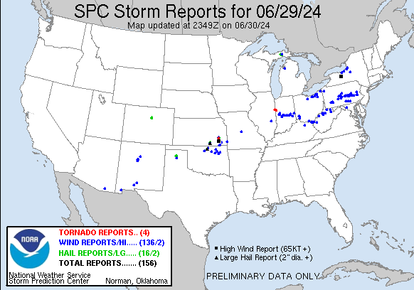