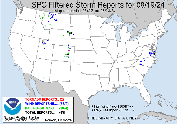
| Tornado Reports (CSV) (Raw Tornado CSV)(?) |
|---|
Time | | Location | County | State | Lat | Lon | Comments |
| 2004 | | 1 W Shamrock | Adams | CO | 3989 | 10383 | Landspout. Estimated to be 4-5 miles south/southeast of Prospect Rd and CR 152 in eastern Adams County. (BOU) |
| 2055 | | 10 NNE Deer Trail | Adams | CO | 3975 | 10399 | Updates tornado report from 10 NNE Deer Trail. Multiple spotters have confirmed location. Tornado lasted about 5-6 minutes. It remained nearly stationary for about 2 mi (BOU) |
| Hail Reports (CSV) (Raw Hail CSV)(?) |
|---|
Time | Size | Location | County | State | Lat | Lon | Comments |
| 2021 | 150 | 3 N Matheson | Elbert | CO | 3922 | 10398 | Report from mPING: Ping Pong Ball (1.50 in.). (BOU) |
| 2039 | 100 | 7 ESE Forest Oaks | Guilford | NC | 3595 | 7960 | Multiple reports of quarter sized hail near the Julian ... NC area. (RAH) |
| 2130 | 175 | 7 E Polaris | Beaverhead | MT | 4537 | 11298 | (TFX) |
| 2215 | 175 | 14 S Bushnell | Kimball | NE | 4104 | 10392 | Radar estimated time of trained storm spotter report of golf ball sized hail occurring. (CYS) |
| 2218 | 150 | 9 SE Ramah | El Paso | CO | 3901 | 10409 | Report from mPING: Ping Pong Ball (1.50 in.). (PUB) |
| 2230 | 200 | 10 SE Ramah | El Paso | CO | 3900 | 10405 | via social media with picture. (PUB) |
| 2245 | 100 | 2 ENE Manhattan | Gallatin | MT | 4587 | 11130 | Corrects previous hail report from 2 ENE Manhattan. Delayed report. Public report of wheat fields damaged by quarter size hail. Time/location estimated. Event occurred (TFX) |
| 2258 | 100 | 5 NNE Huson | Missoula | MT | 4709 | 11428 | (MSO) |
| 2312 | 100 | 2 E Security | El Paso | CO | 3874 | 10469 | Report from mPING: Quarter (1.00 in.). (PUB) |
| 2331 | 150 | 6 NE Kutch | Elbert | CO | 3898 | 10382 | (BOU) |
| 2336 | 100 | 8 ENE Tucson | Pima | AZ | 3225 | 11077 | Video and comment on social media showing heavy rain and hail with an estimated size of 1 inch diameter. (TWC) |
| 2336 | 100 | 7 ENE Antelope Springs | Morgan | CO | 4048 | 10360 | (BOU) |
| 2338 | 100 | 2 N Fountain | El Paso | CO | 3871 | 10470 | Report from mPING: Quarter (1.00 in.). (PUB) |
| 2350 | 275 | Devils Tower | Crook | WY | 4459 | 10471 | Wind driven baseball size hail broke out windows on vehicles ... buildings ... and campers. (UNR) |
| 0006 | 150 | 1 NE Moiese | Lake | MT | 4738 | 11425 | Two rounds of hail in and around the Bison Range. Gusts to 53 mph with the first round of hail. (MSO) |
| 0030 | 150 | 8 NNE Sundance | Crook | WY | 4452 | 10432 | Hail is covering the ground. (UNR) |
| 0040 | 100 | 1 NW Choteau | Teton | MT | 4782 | 11219 | Hail fell for about 10 minutes. (TFX) |
| 0100 | 150 | 3 ESE Bigfork | Lake | MT | 4805 | 11400 | (MSO) |
| 0132 | 100 | Dwtn Spearfish | Lawrence | SD | 4450 | 10386 | (UNR) |
| 0140 | 100 | 1 ESE Olney Springs | Crowley | CO | 3816 | 10393 | Relayed via broadcast media. (PUB) |
| 0143 | 100 | 1 W Columbia Falls | Flathead | MT | 4837 | 11421 | (MSO) |
| 0145 | 200 | 3 ESE Cheyenne Crossing | Lawrence | SD | 4428 | 10381 | (UNR) |
| 0145 | 175 | Deadwood | Lawrence | SD | 4438 | 10373 | (UNR) |
| 0200 | 175 | 2 SW Galena | Lawrence | SD | 4431 | 10368 | (UNR) |
| 0201 | 200 | Brownsville | Lawrence | SD | 4427 | 10369 | (UNR) |
| 0210 | 100 | 5 SE Linch | Johnson | WY | 4355 | 10614 | Large accumulations of hail ... varying in size from 0.5 to 1.00 inch. Pictures showed accumulations of 1 to 2 inches of hail on the ground. (RIW) |
| 0215 | 150 | Avondale | Pueblo | CO | 3824 | 10435 | (PUB) |
| 0238 | 125 | Tilford | Meade | SD | 4430 | 10343 | (UNR) |
| 0315 | 100 | 3 W Galena | Lawrence | SD | 4433 | 10371 | (UNR) |
| 0400 | 175 | 9 NE Tilford | Meade | SD | 4439 | 10330 | (UNR) |
| 0450 | 100 | Box Elder | Pennington | SD | 4412 | 10307 | (UNR) |
| Wind Reports (CSV) (Raw Wind CSV)(?) |
|---|
Time | Speed | Location | County | State | Lat | Lon | Comments |
| 1910 | UNK | 1 WSW Cascade | Pittsylvania | VA | 3656 | 7968 | A tree has fallen across the road onto power lines. (RNK) |
| 1950 | UNK | 1 SW Winterpock | Chesterfield | VA | 3733 | 7774 | Tree down on power lines near River Rd. Time Estimated from Radar. (AKQ) |
| 1950 | UNK | 2 SW Midlothian | Chesterfield | VA | 3749 | 7766 | Tree Down across road at intersection of Nailor Way and Newberg Lane. Time estimated by radar. (AKQ) |
| 1950 | UNK | 1 SW Ashland | Hanover | VA | 3776 | 7748 | A COOP observer reported a large tree snapped and fallen over in Ashland. The tree appeared to be rotten on the inside. (AKQ) |
| 1953 | UNK | Sheffield | Davie | NC | 3597 | 8068 | Tree and power lines fell on a vehicle on Dyson Rd and trapped occupant. Time estimated. (GSP) |
| 1958 | UNK | 2 NNE Winterpock | Chesterfield | VA | 3737 | 7770 | Tree down on power line at intersection of Beach Rd and Otterdale Rd. Time estimated from Radar. (AKQ) |
| 2015 | UNK | 5 SE Turnersburg | Iredell | NC | 3586 | 8073 | Trees down on Cool Springs Rd. (GSP) |
| 2020 | UNK | 1 NE Stony Point | Iredell | NC | 3588 | 8103 | Trees down on Stikeleather Rd just on Iredell side of county line. Time estimated. (GSP) |
| 2020 | UNK | 2 S Sandston | Henrico | VA | 3748 | 7727 | Tree and powerlines down along Poplar Springs Road. (AKQ) |
| 2023 | UNK | 2 NNW Stony Point | Alexander | NC | 3589 | 8106 | Trees and lines down at Cheatham Ford Rd and Lawzyday Farm Dr. Time estimated. (GSP) |
| 2026 | UNK | 3 SW Roxbury | Charles City | VA | 3744 | 7718 | Tree down across Old Union Rd near Perks Lane. (AKQ) |
| 2028 | UNK | Stony Point | Alexander | NC | 3586 | 8105 | Numerous trees down in and just north of Stony Point. Tree fell on a building on Alexander Rd and trapped animals inside. (GSP) |
| 2029 | UNK | Barnetts | Charles City | VA | 3737 | 7716 | Tree down near intersection of Barnetts Rd and Church Lane. (AKQ) |
| 2029 | UNK | 1 W Wrights Corner | New Kent | VA | 3750 | 7716 | Trees down. (AKQ) |
| 2029 | UNK | 2 NE Bottoms Bridge | New Kent | VA | 3753 | 7716 | Trees and power lines down in the road. (AKQ) |
| 2039 | UNK | 6 ESE Forest Oaks | Guilford | NC | 3594 | 7961 | Fallen trees caused power outage south of NC-62 near Bowman Dairy Rd. (RAH) |
| 2039 | UNK | 2 SSW Barnetts | Charles City | VA | 3734 | 7718 | Multiple trees and power lines down along Route 5. Time estimated from radar. (AKQ) |
| 2039 | UNK | 2 S Mountcastle | Charles City | VA | 3743 | 7709 | Tree down along Alpine Road. (AKQ) |
| 2042 | UNK | 2 E Ruthville | Charles City | VA | 3737 | 7700 | Tree Down on Sturgeon Point Rd near The Glebe Lane. (AKQ) |
| 2042 | UNK | 1 N Mountcastle | New Kent | VA | 3747 | 7710 | Large tree limbs down. (AKQ) |
| 2054 | 58 | 6 NE Nogales | Santa Cruz | AZ | 3142 | 11085 | ASOS station KOLS Nogales International Airport. (TWC) |
| 2100 | 60 | 8 S Shamrock | Adams | CO | 3977 | 10380 | (BOU) |
| 2103 | UNK | 2 N Prince George Golf | Prince George | VA | 3718 | 7727 | 2 trees down on Prince George Drive. (AKQ) |
| 2103 | UNK | 9 SSE Shamrock | Adams | CO | 3978 | 10374 | Large tree limb ... 6 inches in diameter ... snapped. Marble hail and torrential rain. (BOU) |
| 2124 | UNK | 2 NW Huske | Sussex | VA | 3691 | 7744 | Tree Down on Woodyard Rd. Time estmated from radar. (AKQ) |
| 2135 | UNK | 1 WNW Yorktown | York | VA | 3724 | 7652 | Tree down near the American Revolution Museum in Yorktown. (AKQ) |
| 2140 | UNK | 1 WNW Harris Grove | York | VA | 3720 | 7650 | Tree down on Route 17 near Yorktown High School. (AKQ) |
| 2152 | UNK | 1 WSW Cramerton | Gaston | NC | 3523 | 8109 | Large tree limbs down on 226 King George Lane. (GSP) |
| 2200 | UNK | 3 S Belmont | Gaston | NC | 3521 | 8104 | Tree down at 1931 South Point Rd. (GSP) |
| 2200 | 58 | 9 SSW Bushnell | Kimball | NE | 4112 | 10398 | AWOS station K1EW 6 SE Pine Bluffs. (CYS) |
| 2204 | UNK | 7 SW Pine Bluffs | Laramie | WY | 4108 | 10412 | Corrects previous tstm wnd dmg report from 7 SW Pine Bluffs. Report from mPING: 3-inch diameter tree limbs broken; Power poles broken. (CYS) |
| 2210 | UNK | 7 SW Pine Bluffs | Laramie | WY | 4108 | 10412 | Report from mPING: 3-inch diameter tree limbs broken; Power poles broken. (CYS) |
| 2215 | 63 | 3 SW Harborton | Accomack | VA | 3762 | 7588 | Personal weather station gusted to 63 mph. (AKQ) |
| 2234 | UNK | 3 E Pineville | Mecklenburg | NC | 3509 | 8084 | One tree down on Pineville-Matthews Rd near Fire Station 24. (GSP) |
| 2234 | 77 | 7 SW Fishermans Island | ANZ632 | VA | 3704 | 7608 | Mesonet station XBBT Third Island. (AKQ) |
| 2258 | 65 | 2 WSW Penrose | Fremont | CO | 3842 | 10504 | Mesonet station CO132 050e290 Penrose. (PUB) |
| 2333 | 63 | 2 ENE Truckton | El Paso | CO | 3874 | 10414 | report relayed via NWS BOU. (PUB) |
| 2343 | UNK | 6 S New Raymer | Morgan | CO | 4052 | 10386 | Report from mPING. (BOU) |
| 2348 | 62 | 2 SSE East Helena | Jefferson | MT | 4657 | 11190 | Public weather station. (TFX) |
| 2350 | 61 | 6 WNW Nephi | Juab | UT | 3973 | 11193 | Measured at the Nephi West PacifiCorp site. (SLC) |
| 2350 | UNK | Devils Tower | Crook | WY | 4459 | 10471 | *** 1 Inj *** Person suffered elbow contusion from flying debris at campground and had to receive medical attention. Numerous reports of broken windows ... building dama (UNR) |
| 2350 | UNK | Hulett | Crook | WY | 4468 | 10460 | Multiple powerline poles are down in the Hullett and Oshoto area. (UNR) |
| 0000 | 58 | 6 ESE East Helena | Jefferson | MT | 4656 | 11179 | Corrects previous non-tstm wnd gst report from 6 ESE East Helena. Mesonet station MTSPK Spokane Creek Us-287 Mp 55.7. (TFX) |
| 0012 | UNK | 1 SW Union | Morgan | CO | 4034 | 10351 | Report from mPING. (BOU) |
| 0111 | 59 | 5 WSW Great Falls | Cascade | MT | 4747 | 11138 | Corrects previous non-tstm wnd gst report from 5 WSW Great Falls. ASOS station KGTF Great Falls Airport. (TFX) |
| 0120 | 63 | 7 E Brady | Pondera | MT | 4804 | 11170 | (TFX) |
| 0125 | 59 | 4 SSW Valier | Pondera | MT | 4825 | 11228 | (TFX) |
| 0151 | UNK | Ordway | Crowley | CO | 3822 | 10375 | Tree limbs down. (PUB) |
| 0155 | 61 | 2 SE Ethridge | Toole | MT | 4854 | 11208 | Mesonet station GW1987 ETHRIDGE THREE SE. (TFX) |
| 0200 | 65 | Lewistown | Fergus | MT | 4707 | 10943 | (TFX) |
| 0200 | 63 | 5 ESE Denton | Fergus | MT | 4730 | 10985 | Mesonet station MTDEN Denton (MT DOT). (TFX) |
| 0206 | UNK | 4 ENE Carter | Chouteau | MT | 4780 | 11088 | Spotter traveling northbound on highway 87 noted two snapped power poles near mile marker 31. Confirmed power outages in the area. (TFX) |
| 0215 | 63 | 7 SE Lothair | Liberty | MT | 4841 | 11111 | Delayed Report. Wunderground sensor KMTCHEST53. (TFX) |
| 0225 | 59 | 7 ESE Hilger | Fergus | MT | 4722 | 10922 | Mesonet station JPKM8 Judith Peak RAWS. Time estimated via radar given RAWS reports once per hour. (TFX) |
| 0225 | 59 | 18 NW Loma | Chouteau | MT | 4811 | 11080 | Mesonet station GW3862 LOMA EIGHTEEN NW. (TFX) |
| 0245 | 58 | 13 S Lakeside | Box Elder | UT | 4103 | 11289 | Lakeside Mountain mesonet site LMR. (SLC) |
| 0245 | 61 | 11 S Rudyard | Hill | MT | 4840 | 11056 | Mesonet station GW3530 RUDYARD ELEVEN SOUTH. (TFX) |
| 0245 | 61 | 6 NNW Sunburst | Toole | MT | 4896 | 11194 | Mesonet station MTSWT Sweetgrass (MT DOT). (TFX) |
| 0300 | 59 | 7 SE Lothair | Liberty | MT | 4841 | 11111 | Delayed Report. Wunderground sensor KMTCHEST53. (TFX) |
| 0310 | 62 | 4 W Havre | Hill | MT | 4854 | 10976 | (TFX) |
| 0335 | 60 | 12 WSW Hereford | Meade | SD | 4433 | 10311 | (UNR) |
| 0400 | 80 | 9 NE Tilford | Meade | SD | 4439 | 10330 | Winds estimated to be at least 80 mph (UNR) |
| 0400 | UNK | 9 NE Tilford | Meade | SD | 4439 | 10330 | Severe barn damage ... numerous trees down. Winds estimated to be at least 80 mph. (UNR) |
| 0425 | 60 | 14 SSE Hereford | Meade | SD | 4419 | 10283 | (UNR) |
| 0445 | UNK | 2 SSW Layton | Davis | UT | 4105 | 11198 | A tree fell through the roof of a home ... rendering it unlivable. Time estimated by radar and nearby observations. (SLC) |
| 0506 | 60 | 3 NW Wasta | Pennington | SD | 4410 | 10250 | (UNR) |
| 0545 | 59 | 5 SSE Laketown | Rich | UT | 4175 | 11128 | Mesonet station OTRU1 Otter Creek. (SLC) |