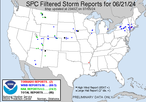
| Tornado Reports (CSV) (Raw Tornado CSV)(?) |
|---|
Time | | Location | County | State | Lat | Lon | Comments |
| 2054 | | Harwinton | Litchfield | CT | 4177 | 7306 | Storm survey confirmed tornado. (ALY) |
| 2225 | | 1 SW Montrose | Ashley | AR | 3329 | 9151 | Corrects previous funnel cloud report from 1 SW Montrose. A brief landspout occurred near Montrose with a passing shower. Photos relayed via Twitter. (JAN) |
| Hail Reports (CSV) (Raw Hail CSV)(?) |
|---|
Time | Size | Location | County | State | Lat | Lon | Comments |
| 1550 | 100 | 4 SW La Sal | San Juan | UT | 3830 | 10923 | (GJT) |
| 1900 | 125 | Eagle Mountain | Utah | UT | 4038 | 11199 | Follow-up public social media picture showing a hailstone near half dollar size in diameter. (SLC) |
| 1915 | 125 | Magna | Salt Lake | UT | 4070 | 11209 | Social media photographs of hailstones ranging from approximately quarter to half dollar size in diameter. (SLC) |
| 1938 | 175 | 7 ESE Big Water | Kane | UT | 3702 | 11154 | Video from social media with hail on Lake Powell near Lone Rock Beach. Time estimated from radar. (SLC) |
| 1938 | 175 | 9 ESE Big Water | Kane | UT | 3702 | 11150 | Video from social media of golf ball size hail and minor boat damage on Lake Powell near Ice Cream Canyon. Time estimated from radar. (SLC) |
| 1938 | 100 | 2 W Draper | Salt Lake | UT | 4050 | 11190 | (SLC) |
| 1947 | 200 | Hobson | Judith Basin | MT | 4700 | 10987 | Trained spotter reported 1 to 2 inch sized hail with torrential rainfall. The hail was completely covering the ground and making it white. (TFX) |
| 1950 | 175 | 5 SE Big Water | Kane | UT | 3701 | 11161 | Golf ball size hail reported at Amangiri Resort. (SLC) |
| 2003 | 125 | 7 SSE Neihart | Meagher | MT | 4684 | 11070 | Hail up to half dollar size falling at Showdown ski area. (TFX) |
| 2025 | 100 | Northfield | Franklin | MA | 4271 | 7244 | (BOX) |
| 2036 | 100 | 11 S Lewistown | Fergus | MT | 4691 | 10941 | Estimated hail up to 1 inch in diameter. Time of event is estimated via radar. (TFX) |
| 2044 | 100 | 5 S Chugwater | Platte | WY | 4168 | 10483 | Fire department responding to vehicle crash. (CYS) |
| 2102 | 150 | 23 SSW Bullfrog | San Juan | UT | 3717 | 11082 | Public reported 1.5 inch hail on the San Juan River near Cha Bay. Time estimated from radar. (SLC) |
| 2116 | 125 | 4 SSE Tolikan (Sweetwat | Apache | AZ | 3680 | 10940 | DELAYED REPORT from June 21. Large hail broke windows in and around Immanuel Mission School. Time estimated from radar. (FGZ) |
| 2130 | 100 | 1 NW Grants | Cibola | NM | 3516 | 10784 | TSTM wind gusts estimated to 50 mph. (ABQ) |
| 2136 | 100 | 5 WSW Bloomfield | San Juan | NM | 3668 | 10805 | Delayed Report. (ABQ) |
| 2141 | 100 | Hereford | Weld | CO | 4097 | 10430 | (BOU) |
| 2142 | 175 | 4 WSW Bloomfield | San Juan | NM | 3668 | 10804 | (ABQ) |
| 2150 | 100 | 2 N Everly | Clay | IA | 4318 | 9532 | Report from mPING: Quarter (1.00 in.). (FSD) |
| 2200 | 175 | Brady | Pondera | MT | 4804 | 11183 | Public Reported Golf Ball sized hail. It was hailing long and hard enough with low enough visibility that all the cars along I-15 had to pull over. (TFX) |
| 2215 | 175 | 4 NW Pawnee Buttes | Weld | CO | 4085 | 10404 | Largest stones fell at the beginning of the storm. Shredded a few window screens. Time estimated by radar. (BOU) |
| 2220 | 125 | 3 NE Pawnee Buttes | Weld | CO | 4085 | 10394 | Hail was slightly smaller than a ping pong ball and took out their screens. (BOU) |
| 2220 | 175 | 8 E Brady | Pondera | MT | 4803 | 11166 | Golf balls reported on the S curve east of Brady on Brady Road (Highway 365). Time and location estimated. (TFX) |
| 2247 | 100 | 6 ENE Dickens | Clay | IA | 4317 | 9492 | In addition to a few dime sized hail stones ... 1.35 inch of rain occurred in 22 minutes as the storm pushed through. (FSD) |
| 2301 | 125 | 10 W Westplains | Weld | CO | 4083 | 10369 | Report from mPING: Half Dollar (1.25 in.). (BOU) |
| 2302 | 250 | 9 SSE The Knees | Chouteau | MT | 4790 | 11118 | 2.50 inch hail size estimated from a photo and damage to a vehicle windshield. Time estimated from radar. (TFX) |
| 2352 | 100 | Moab 1SE | Grand | UT | 3852 | 10948 | Brief heavy rain. (GJT) |
| 2357 | 100 | 3 SE Moab | Grand | UT | 3853 | 10951 | (GJT) |
| 0025 | 150 | 6 E Malmstrom Afb | Cascade | MT | 4750 | 11106 | Time and location estimated. Hailstones between 1 and 1.5 inches. (TFX) |
| Wind Reports (CSV) (Raw Wind CSV)(?) |
|---|
Time | Speed | Location | County | State | Lat | Lon | Comments |
| 1645 | UNK | 4 S Morris | Otsego | NY | 4249 | 7525 | Trees down near CR-8 and CR-10 in Town of Butternuts. Time estimated by radar. (BGM) |
| 1740 | UNK | Union Center | Ulster | NY | 4185 | 7400 | Tree and wires down on Carney Road near Ulster Park. (ALY) |
| 1740 | UNK | Ulster Park | Ulster | NY | 4186 | 7398 | Tree down blocking Union Center Road in Ulster Park. (ALY) |
| 1744 | UNK | Esopus | Ulster | NY | 4183 | 7397 | Trees down on Route 9W in the Town of Esopus. (ALY) |
| 1744 | UNK | Ulster Park | Ulster | NY | 4186 | 7397 | Trees down on Route 9W in the Town of Esopus. (ALY) |
| 1810 | UNK | 3 ESE Honeoye | Ontario | NY | 4278 | 7746 | Time estimated based on radar. Tree down on a power line which was smoking. (BUF) |
| 1833 | UNK | 4 NNW Rushville | Ontario | NY | 4281 | 7726 | Time estimated based on radar. Tree leaning on wires. (BUF) |
| 1837 | UNK | Orchard Park | Saratoga | NY | 4293 | 7390 | Tree down on house (ALY) |
| 1842 | UNK | 1 SW Carlyle West | Saratoga | NY | 4293 | 7384 | Wires down on Round Lake Road near Ballston Lake. (ALY) |
| 1845 | UNK | 1 WSW Jonesville | Saratoga | NY | 4290 | 7384 | Wires down along Mac Elroy Road near Jonesville. (ALY) |
| 1849 | UNK | 1 NNW Clifton Park Cent | Saratoga | NY | 4287 | 7383 | Medium to large branch down near the corner of Chillmark Turn and Tisdale Lane in Clifton Park. (ALY) |
| 1850 | UNK | 2 N Mohawk View | Saratoga | NY | 4281 | 7379 | Wires down along Stockton Court in Clifton Park. (ALY) |
| 1910 | UNK | Greene | Chenango | NY | 4233 | 7577 | Photos relayed of downed trees. Timed estimated by radar. (BGM) |
| 1915 | UNK | 1 E Sycaway | Rensselaer | NY | 4274 | 7363 | A couple of wires were reported down in the vicinity of North Troy and Brunswick. (ALY) |
| 1922 | UNK | 1 N Kingston | Ulster | NY | 4194 | 7400 | Tree on wires on Harwich Street in Kingston. (ALY) |
| 1949 | UNK | Williamsville | Berkshire | MA | 4226 | 7338 | Tree down blocking Great Barrington Road. (ALY) |
| 1953 | UNK | Stockbridge | Berkshire | MA | 4229 | 7332 | Tree down blocking Church Street in Stockbridge. (ALY) |
| 1954 | UNK | 1 NNW South Lee | Berkshire | MA | 4229 | 7329 | Trees down on Lee Road near Stockbridge. (ALY) |
| 1959 | UNK | 1 NE Lee | Berkshire | MA | 4232 | 7323 | Trees and wires down along East Street in Lee. (ALY) |
| 2002 | UNK | 1 W Littlerest | Dutchess | NY | 4177 | 7367 | Tree down across Hoxie Road near Millbrook. (ALY) |
| 2019 | UNK | Northfield | Franklin | MA | 4271 | 7244 | Police report tree down along the 60 block of Hinsdale Road. Relayed by amateur radio. (BOX) |
| 2020 | UNK | Kent | Litchfield | CT | 4172 | 7348 | Trees down. (ALY) |
| 2022 | UNK | 2 SE West Hartford | Hartford | CT | 4174 | 7273 | Police report trees and wires down on South Highland Street and tree and wires down on Quaker Lane. Relayed by amateur radio. (BOX) |
| 2022 | UNK | 2 ESE West Hartford | Hartford | CT | 4176 | 7272 | Tree down on Overlook Road and on Beverly Road. Relayed by amateur radio. (BOX) |
| 2025 | UNK | Painted Post | Steuben | NY | 4216 | 7709 | Trees and wires down over road. (BGM) |
| 2032 | UNK | East Windsor | Hartford | CT | 4185 | 7260 | Tree down near South Road and Phelps Road. Utility pole and wires down at intersection of Phelps Road and Route 5. Relayed by amateur radio. (BOX) |
| 2047 | UNK | 2 E Sun Prairie | Dane | WI | 4318 | 8920 | A few reports of trees down. (MKX) |
| 2050 | 67 | 3 SSE Birdseye | Utah | UT | 3988 | 11152 | Mesonet station UTTP6 US-89 at Pole Creek BS. (SLC) |
| 2054 | UNK | Harwinton | Litchfield | CT | 4177 | 7306 | Trees down on Birge Park Rd Rte 4. Possible tornado. (ALY) |
| 2057 | UNK | Elmira Heights | Chemung | NY | 4213 | 7683 | Wires down across road. (BGM) |
| 2101 | UNK | 1 NNE Elmira Heights | Chemung | NY | 4214 | 7681 | Latta Brook Road from Sandys Lane to Burns Road in Horseheads NY closed & impassable due to tree down in roadway. (BGM) |
| 2101 | UNK | Horseheads | Chemung | NY | 4217 | 7684 | Tree limbs broken; Shingles blown off. (BGM) |
| 2103 | UNK | 1 SSW Elmira Heights | Chemung | NY | 4211 | 7683 | Trees and wires down. (BGM) |
| 2106 | 59 | 4 E North Platte | Lincoln | NE | 4113 | 10069 | (LBF) |
| 2108 | UNK | 1 SSE Bristol | Ontario | NY | 4283 | 7741 | Time estimated based on radar. Multiple instances of wires down near County Route 20A between Elm Tree Road and the Bristol Valley Mobil Park. (BUF) |
| 2108 | UNK | 1 S Bristol | Ontario | NY | 4283 | 7742 | Time estimated based on radar. Tree downed onto property which caused a meter to be ripped from a home. (BUF) |
| 2108 | UNK | Waterloo | Jefferson | WI | 4318 | 8899 | Report of multiple 2 to 3 inch branches down in downtown Waterloo on Madison St. (MKX) |
| 2112 | UNK | Plymouth | Litchfield | CT | 4167 | 7305 | Trees down. (ALY) |
| 2115 | UNK | 4 SSE Tolikan (Sweetwat | Apache | AZ | 3680 | 10940 | DELAYED REPORT from June 21. Strong thunderstorm winds blew roofs from structures around Immanuel Mission. Windblown hail broke windows. Time estimated from radar. (FGZ) |
| 2115 | UNK | 5 ESE Phelps | Ontario | NY | 4293 | 7698 | Tress down on wires near the intersection of Cross road and State Route 14. (BUF) |
| 2125 | UNK | Agawam | Hampden | MA | 4207 | 7262 | Police report tree down on road ... blocking traffic along Pine Street. Trained spotter reports tree down along Suffield Street. Relayed by amateur radio. (BOX) |
| 2128 | UNK | Otego | Otsego | NY | 4239 | 7518 | Trees and wires down over road. (BGM) |
| 2128 | UNK | 1 WNW Otego | Otsego | NY | 4239 | 7519 | Corrects previous tstm wnd dmg report from 1 WNW Otego. Trees and wires down over Wayman Drive in Otego NY. (BGM) |
| 2128 | UNK | 2 N North Franklin | Delaware | NY | 4242 | 7508 | Trees down blocking road. (BGM) |
| 2135 | UNK | Bloomfield | San Juan | NM | 3671 | 10798 | Delayed Report. Aluminum outbuilding destroyed and tossed onto mobile home. (ABQ) |
| 2135 | 61 | 3 WSW Roosevelt | Duchesne | UT | 4028 | 11005 | AWOS station K74V Roosevelt Airport. (SLC) |
| 2137 | 62 | 6 SW Tucson | Pima | AZ | 3213 | 11095 | Corrects previous non-tstm wnd gst report from 6 SW Tucson. ASOS station KTUS Tucson International Airport. (TWC) |
| 2141 | UNK | 1 SW Flora Vista | San Juan | NM | 3679 | 10810 | Updates previous tstm wnd dmg report from 1 SW Flora Vista. Power lines down and at least 2 poles broken on the road off Old Aztec Highway (CR 3520) between Penny Lane (ABQ) |
| 2141 | 60 | Hereford | Weld | CO | 4097 | 10430 | (BOU) |
| 2142 | 72 | 6 SW Tucson | Pima | AZ | 3213 | 11095 | ASOS station KTUS Tucson International Airport. (TWC) |
| 2142 | 80 | 4 WSW Bloomfield | San Juan | NM | 3669 | 10802 | TSTM wind gusts estimated between 70 to 80mph. (ABQ) |
| 2150 | UNK | 4 ESE Farmington | San Juan | NM | 3673 | 10813 | Single wide mobile home pushed off its blocks. Photos show minor damage. Time estimated. (ABQ) |
| 2200 | UNK | 5 WNW Tucson | Pima | AZ | 3223 | 11097 | Tree damage near the intersection of 6th St and N Arizona Ave. Time estimated by radar. (TWC) |
| 2205 | UNK | 3 SSE Farmington | San Juan | NM | 3672 | 10816 | Large twenty year old live tree downed by outflow winds. Report forwarded by local media. (ABQ) |
| 2208 | 65 | 3 SE Farmington | San Juan | NM | 3673 | 10815 | Heavy rain. (ABQ) |
| 2212 | 72 | 1 E Vernal | Uintah | UT | 4045 | 10952 | ASOS station KVEL Vernal Rgnl Airport. (GJT) |
| 2213 | UNK | 3 ESE Owego | Tioga | NY | 4209 | 7621 | Trees reported down across the roadway. (BGM) |
| 2216 | 75 | 4 WNW Spencer | Clay | IA | 4317 | 9522 | ASOS station KSPW Spencer Municipal Airport. (FSD) |
| 2220 | 60 | 3 NE Pawnee Buttes | Weld | CO | 4085 | 10394 | (BOU) |
| 2225 | UNK | 1 NE Croton-on-Hudson | Westchester | NY | 4121 | 7388 | Tree down on NY 129 west of Batten Rd ... all of 2 lanes closed. (OKX) |
| 2226 | UNK | 2 WSW Endicott | Broome | NY | 4209 | 7609 | Tree and wires down on roadway. (BGM) |
| 2226 | UNK | 1 ENE Endicott | Broome | NY | 4210 | 7605 | Wires down over roadway. (BGM) |
| 2227 | 65 | Orland | Lake | SD | 4389 | 9719 | Strong wind gusts for about 5 minutes ahead of the storm estimated at 60 to 70 mph. Blew sticks and branches all over the yard. (FSD) |
| 2229 | UNK | 1 WSW Endwell | Broome | NY | 4211 | 7604 | Large uprooted tree. (BGM) |
| 2236 | UNK | Columbus | St. Clair | MI | 4288 | 8266 | Four large tree limbs down around 8 inches in diameter (DTX) |
| 2302 | UNK | 2 WSW North Stonington | New London | CT | 4143 | 7193 | Spotter reports tree down ... six inches in diameter ... on Al Harvey Rd near the intersection of Rt 201. Time estimated from radar. (OKX) |
| 2320 | UNK | 1 SE Pittston | Luzerne | PA | 4132 | 7578 | Tree limbs broken; Shingles blown off. (BGM) |
| 2323 | UNK | 3 SSW Brewster | Westchester | NY | 4135 | 7364 | tree down blocking 1 of 3 lanes on I-684 southbound ... north of exit 8. (OKX) |
| 2327 | 58 | 17 NW Moab | Grand | UT | 3876 | 10974 | Northwest wind direction. (GJT) |
| 2343 | 64 | 19 N Dixon | Carbon | WY | 4131 | 10757 | Mesonet station COWW4 21 NNE Baggs - Cow Creek Raws - Cow. (CYS) |
| 2351 | 70 | 5 N Black Eagle | Cascade | MT | 4760 | 11129 | 70 mph wind gust. Location is estimated. (TFX) |
| 2352 | UNK | 3 W Carverton | Luzerne | PA | 4135 | 7590 | Trees and wires down on roadway. (BGM) |
| 2354 | UNK | West Wyoming | Luzerne | PA | 4132 | 7585 | Trees and wires down over Shoemaker Avenue. (BGM) |
| 0019 | 66 | 2 SE Craig | Moffat | CO | 4049 | 10752 | Direction was west. (GJT) |
| 0020 | UNK | 3 SSW Willow Island | Dawson | NE | 4084 | 10008 | Areas of tree damage and several center pivots overturned or partial damaged. (GID) |
| 0030 | UNK | Craig | Moffat | CO | 4052 | 10755 | 4 inch limbs and smaller branches downed. Vendor tents blown away and porta potties blown down during Whittle the Wood event as reported on Social Media. (GJT) |
| 0030 | UNK | 2 ESE Cozad | Dawson | NE | 4085 | 9995 | Tree damage in and around the Cozad Country Club and 3 or 4 center pivots damaged just to the east of the course. (GID) |
| 0111 | 67 | 5 NNW Dwtn Gillette | Campbell | WY | 4434 | 10554 | (UNR) |
| 0138 | UNK | 1.5 N Miller | Buffalo | NE | 4095 | 9939 | Tree blown over laying across Hwy 183. (GID) |
| 0143 | UNK | 3 N East Windsor | Hartford | CT | 4189 | 7260 | 3-inch tree limbs broken; Power poles broken. (BOX) |
| 0215 | UNK | Sibley | Osceola | IA | 4340 | 9574 | Power outages and trees down in Sibley. Time estimated via radar. (FSD) |
| 0221 | UNK | 4 NNW Florence Junction | Pinal | AZ | 3331 | 11137 | ***DELAYED REPORT*** Large palo verde tree fully uprooted along a park located in North Entrada del Oro Blvd. in Gold Canyon ... AZ. (PSR) |
| 0222 | UNK | 1 ENE Sheldon | O'Brien | IA | 4319 | 9582 | Storm damage on east side of Sheldon. Campers tossed and damaged ... building and tree damage reported ... including to fireworks stand. Time estimated via radar. (FSD) |
| 0230 | 60 | 6 N North Cheyenne | Laramie | WY | 4131 | 10479 | (CYS) |
| 0245 | 58 | 4 NE Clarks | Merrick | NE | 4125 | 9778 | (GID) |
| 0251 | UNK | Hayden | Routt | CO | 4049 | 10726 | Large tree blown down blocking Maple Street. Police Dept. reports 1 car smashed by tree as per social media post. (GJT) |
| 0402 | UNK | 1 W Spencer | Clay | IA | 4314 | 9516 | Report from mPING: 1-inch tree limbs broken; Shingles blown off. Time estimated via radar. (FSD) |
| 0413 | 60 | Spencer | Clay | IA | 4315 | 9515 | Spotter reported gusts in Spencer of 60+ mph. (FSD) |
| 0600 | 60 | Freeport Albertus | Stephenson | IL | 4225 | 8958 | AWOS station KFEP Freeport Arpt. NWS LOT was dialed into the site at the time of the report. (DVN) |
| 0800 | UNK | North Platte | Lincoln | NE | 4113 | 10077 | Roof collapsed at TJ Maxx North Platte Mall. (LBF) |
| 0807 | UNK | 3 E North Platte | Lincoln | NE | 4113 | 10071 | Lee Bird Field North Platte. Several hanger doors bent. One removed. 2 Dumpsters moved about 40 feet. (LBF) |
| 0807 | 79 | 3 ENE North Platte | Lincoln | NE | 4115 | 10072 | KLBF ASOS. (LBF) |
| 0856 | 61 | 9 WSW Callaway | Custer | NE | 4124 | 10008 | Pea size hail also. (LBF) |


 @NWSSPC